Arizona Trail
The Arizona National Scenic Trail is a National Scenic Trail from Mexico to Utah that traverses the whole north–south length of the U.S. state of Arizona. The trail begins at the Coronado National Memorial near the US–Mexico border and moves north through parts of the Huachuca, Santa Rita, and Rincon Mountains. The trail continues through the Santa Catalina north of Tucson and the Mazatzal Mountains before ascending the Mogollon Rim north of Payson, eventually leading to the higher elevations of Northern Arizona and the San Francisco Peaks. The trail then continues across the Coconino Plateau and in and out of the Grand Canyon. The Arizona Trail terminates near the Arizona-Utah border in the Kaibab Plateau region. The 800-mile (1,300 km) long Arizona Trail was completed on December 16, 2011. The trail is designed as a primitive trail for hiking, equestrians, mountain biking, and even cross country skiing, showcasing the wide variety of mountain ranges and ecosystems of Arizona.
| Arizona Trail | |
|---|---|
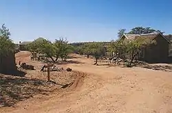 Kentucky Camp, along the Arizona Trail in the Santa Rita Mountains. | |
| Length | 800 mi (1287 km) |
| Location | Arizona, United States |
| Designation | National Scenic Trail |
| Trailheads | Coronado National Memorial Arizona-Utah border |
| Use | Hiking, horseback riding, mountain biking, cross-country skiing |
| Elevation | |
| Highest point | San Francisco Peaks (This point is on a proposed section of the trail), 9,600 ft (2,900 m) |
| Lowest point | Gila River, 1,700 ft (520 m) |
| Hiking details | |
| Trail difficulty | Easy to Strenuous |
| Season | Year-round at lower elevations, Summer and Fall at higher elevations |
| Sights | Santa Catalina Mountains, Mogollon Rim, San Francisco Peaks, Grand Canyon |
The idea for the trail was originally developed and promoted in 1985 by Dale Shewalter, a Flagstaff, Arizona, teacher.[1] The Arizona Trail was designated as a National Scenic Trail on March 30, 2009 by the Omnibus Public Land Management Act of 2009. It forms part of the shortened version of the 6,875-mile (11,064 km) Great Western Loop. This version includes the Grand Canyon National Park.
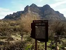 Sign for the Arizona Trail as it passes near Picketpost Mountain (background) in Superior, Arizona. |
References
- "Arizona Trail founder dies". Arizona Daily Sun. 2010-01-11. Retrieved 2010-02-08.
External links
- Arizona Trail Association
- Arizona State Parks: Arizona Trail fact sheet
- Trail Segments - HikeArizona.COM
- Trailheads Map - HikeArizona.COM
- Arizona Trail Forum
- Arizona Trail Backpacking Journals
| Authority control |
|---|
