Mississippi National River and Recreation Area
The Mississippi National River and Recreation Area is a 72-mile (116 km) and 54,000-acre (22,000 ha) protected corridor along the Mississippi River through the Minneapolis–Saint Paul metro in the U.S. state of Minnesota, from the cities of Dayton and Ramsey, to just downstream of Hastings. This stretch of the upper Mississippi River includes natural, historical, recreational, cultural, scenic, scientific, and economic resources of national significance. This area is the only national park site dedicated exclusively to the Mississippi River. The Mississippi National River and Recreation Area is sometimes abbreviated as MNRRA (often pronounced like "minn-ruh") or MISS, the four letter code assigned to the area by the National Park Service. The Mississippi National River and Recreation Area is classified as one of four national rivers in the United States, and despite its name it is technically not one of the 40 national recreation areas.
| Mississippi National River and Recreation Area | |
|---|---|
 | |
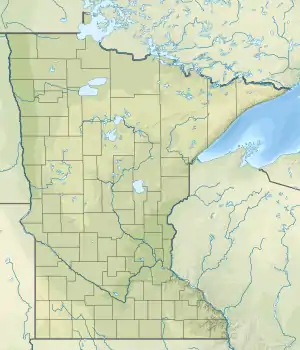  | |
| Location | Minnesota, United States |
| Nearest city | Minneapolis/St. Paul, Minnesota |
| Coordinates | 44°52′24″N 93°01′08″W[1] |
| Area | 53,775 acres (21,762 ha)[2] |
| Established | November 18, 1988 |
| Visitors | 127,635 (in 2015)[3] |
| Governing body | National Park Service along with other private organizations. |
| Website | Mississippi National River and Recreation Area |
History
The Mississippi National River and Recreation Area was established in 1988 as a new unique type of national park known as a partnership park. Unlike traditional national parks, the National Park Service is not a major land owner and therefore does not have control over land use. The National Park Service works in partnership with several partners (e.g., local, state, and federal governments, non-profits, businesses, educational institutions, and individual people) who own land along the river or who have an interest in the Mississippi River to achieve the National Park Service's mission to protect and preserve for future generations. Some of the most prominent attractions within the park include the St. Anthony Falls Historic District (including Mill City Museum, the Guthrie Theater, the Stone Arch Bridge, and Mill Ruins Park), the Historic Fort Snelling and the adjacent Fort Snelling State Park, Minnehaha Falls, and the rustic Winchell Trail. There are many additional attractions, trails, and programs all within the Minneapolis–St. Paul metropolitan area. It is located in parts of Anoka, Dakota, Hennepin, Ramsey, and Washington counties, all within the Minneapolis–Saint Paul metropolitan area.
As of 2016, the area has two visitor centers, one located inside the Science Museum of Minnesota in St. Paul and the other at Upper St. Anthony Falls Lock and Dam in Minneapolis, both of which are staffed by National Park Service rangers. The Minneapolis visitor center offers three free tours daily of the Upper Saint Anthony Lock and surrounding area. Each year, the rangers manage community activities, including interpretive sessions, bike rides, and movies, that help to educate the local community about the natural and human history of the area.
Sections
The Mississippi National River and Recreation Area is between River Miles 879 and 806. The National Park Service categorizes it into five approximate sections:[4]
- The Wild and Scenic River (River Mile 879 to 863) — North of the Twin Cities the river is a state wild and scenic river, slowing as it reaches the Coon Rapids Dam. This segment begins at the confluence of Crow River and the Mississippi near Ramsey and Dayton and flows to Banfil Island at Brooklyn Park and Fridley.
- The River of the Falls/The Urban River (River Mile 862 to 852) — From Brooklyn Center the river approaches several falls, beginning with Saint Anthony, and enters the historic Milling District near downtown Minneapolis.
- The Gorge/Where the Rivers Meet (River Mile 852 to 843) — After the Milling District, the river enters the Mississippi gorge that extends past Fort Snelling State Park to its confluence with the Minnesota River.
- The Working River (River Mile 840 to 833) — From near downtown Saint Paul, the river begins to feature tow boats and barge traffic as it winds to the Pig's Eye Lake Scientific and Natural Area.
- The Forested Floodplain (River Mile 833 to 806) — From South Saint Paul, the river widens further with numerous backwaters and the bluffs are higher. Past Hastings and toward the Vermillion River, the Mississippi becomes wilder again.
Places to visit
The park's website lists the following locations or features as partner sites.[5]
| Partner Site | River Mile[6] | Management Level[7] | Managing Body[7] | Area[7] | Date Opened to Public[7] | Summary[7] |
|---|---|---|---|---|---|---|
| Akin Riverside Park | ~871.7 45°11′41″N 93°23′28″W | City | City of Anoka Parks & Recreation | 6.5 acres (2.6 ha) | Interprets Anoka city history just above the mouth of the Rum River. The 1914 Windego Park Auditorium/Open Air Theater is on the NRHP. | |
| Ard Godfrey House | ~854.5 44°59′19″N 93°15′24″W | City | Minneapolis Park and Recreation Board, The Woman's Club of Minneapolis | 1979 | Built 1849, the oldest wood-frame house in Minneapolis. | |
| Banfill-Locke Center for the Arts | ~862 45°5′20″N 93°16′34″W | County/Non-profit | Anoka County Parks, Banfill-Locke Center for the Arts | 1988 | Supports local artists with exhibits and classes in a renovated 1847 inn. Located in Manomin County Park. | |
| Battle Creek Regional Park | ~834–837 44°56′27″N 93°0′17″W | County | Ramsey County Parks and Recreation | 1,840 acres (740 ha) | 1925[8] | Park comprises three parcels, including a ravine where Dakotas won a battle against Ojibwe intent on attacking Kaposia village in 1842. |
| Bohemian Flats | unkown 44.975278°N 93.241389°W | City | Minneapolis Park and Recreation Board | unkown | 1867 | Park on the west bank of the Mississippi River near the Univerisyt of Minnesota that was the former site of a shanty town in the city's early history. |
| Boom Island Park | 854.8 44°59′37″N 93°16′9″W | City | Minneapolis Park and Recreation Board | 22.5 acres (9.1 ha)[9] | 1987[9] | Once the site of log booms to sort lumber to the owning sawmill, this former island features a marina, riverboat tours, and an ornamental lighthouse. |
| The Brickyards of St. Paul | ~841.5 44°55′6″N 93°6′44″W | City | St. Paul Parks and Recreation | N/A | 2007[10] | Kiln ruins and shale quarries remain from a brickmaking company that operated from 1894 to the 1970s. Fossil collecting and ice climbing are allowed in the quarries with a permit. Part of Lilydale Regional Park. |
| Bruce Vento Nature Sanctuary | ~838.5 44°57′11″N 93°4′29″W | City | St. Paul Parks and Recreation | 29 acres (12 ha) | 2005 | Rehabilitated from a former trainyard and industrial site. Includes Wakan Tipi/Carver's Cave. |
| Coldwater Spring | ~840.0 44°53.96′N 93°11.77′W | Federal | National Park Service | N/A | 2012 | Natural spring and restored prairie site formerly known as Camp Coldwater, located in the Fort Snelling unorganized territory in Hennepin County. |
| Coon Rapids Dam Regional Park (East) | 865–867.7 45°8′55″N 93°18′28″W | County | Anoka County Parks | 446 acres (180 ha) | 1994[11] | Features pedestrians and non-motorized traffic access to the 1913 Coon Rapids Dam, plus river and lake fishing and a visitor center. |
| Coon Rapids Dam Regional Park (West) | 865–867.7 45°8′41″N 93°19′14″W | Park district | Three Rivers Park District | 160 acres (65 ha) | 1969[11] | Features pedestrians and non-motorized traffic access to the 1913 Coon Rapids Dam, plus a visitor center. |
| Crosby Farm Regional Park | 842.3–845.4 44°53′53″N 93°9′47″W | City | St. Paul Parks and Recreation | 736 acres (298 ha) | 1962[8] | Restored bottomland hardwood forest and wetlands that were farmed from 1858 to 1962. Hiking trails and location of the Watergate Marina. |
| Father Hennepin Bluffs Park | ~853.7 44°58′54″N 93°14′57″W | City | Minneapolis Park and Recreation Board | 8 acres (3.2 ha) | 1979[9] | Father Louis Hennepin, the first European to describe St. Anthony Falls, saw them from this site in 1680. |
| First Bridge Park | ~854.4 44°59′4″N 93°15′52″W | City | Minneapolis Park and Recreation Board | 22 acres (8.9 ha)[9] | 2001[9] | Interpretive signage and public art beneath the Hennepin Avenue Bridge commemorate the site of the first permanent bridge crossing the Mississippi, built in 1855. |
| Fort Snelling State Park | 843.9 44°52′15″N 93°11′47″W | State | Minnesota Department of Natural Resources | 2,931 acres (1,186 ha) | 1961 | Includes Pike Island and bottomland hardwood forest at the confluence of the Mississippi and Minnesota Rivers. |
| Fountain Cave | ~841.6 45°5′20″N 93°16′34″W | N/A | N/A | N/A | N/A | A historical marker shows the former location of a sandstone cave, site of the first building in St. Paul (Pierre Parrant's tavern) and later a tourist attraction. The cave was ruined by sewage and the entrance was sealed in 1960 during road construction. |
| Gluek Park | ~856.2 45°5′20″N 93°16′34″W | City | Minneapolis Park and Recreation Board | 2.9 acres (1.2 ha)[9] | 1994 | Established on the site of the 1857 Gluek Brewery following its demolition in 1970.[9] |
| Gold Medal Park | ~853.6 45°5′20″N 93°16′34″W | City | Minneapolis Park and Recreation Board | 7.5 acres (3.0 ha) | 2007 | Selected as the future site of a memorial to the victims of the I-35W Mississippi River bridge collapse. |
| Grey Cloud Dunes Scientific and Natural Area | 821 44°52′15″N 93°11′47″W | State | Minnesota Department of Natural Resources | 237 acres (96 ha) | 1998 | Preserves a sandy prairie with dunes and blowouts on river terraces. |
| Grey Cloud Island | 821–825 45°5′20″N 93°16′34″W | City | Grey Cloud Island Township | 2,000 acres (810 ha)[12] | N/A | An island named after Grey Cloud Woman, a 19th-century Mdewakanton. The 1846 Grey Cloud Lime Kiln is on the NRHP. |
| Harriet Island Regional Park | 839.5–840.5 44°53′53″N 93°9′47″W | City | St. Paul Parks and Recreation | 1900 | Named for educator Harriet Bishop and now connected to shore, this former island has long been the site of public amenities and festivals. The Harriet Island Pavilion is on the NRHP. | |
| Hidden Falls Regional Park | 845.4–847.4 44°53′53″N 93°9′47″W | City | St. Paul Parks and Recreation | 134 acres (54 ha)[13] | 1887 | One of St. Paul's original parks, designed by Horace Cleveland. Features a spring-fed waterfall in a stone channel built by the Works Progress Administration. |
| Historic Fort Snelling | 845.5 45°5′20″N 93°16′34″W | State | Minnesota Historical Society | Begun as a wilderness outpost in 1819 at the strategic confluence of the Mississippi and Minnesota Rivers, and staffed by the U.S. Army through World War II, when it served as a major processing center for new servicemen. Now a National Historic Landmark. | ||
| Indian Mounds Regional Park | ~838 44°56′48″N 93°3′39″W | City | St. Paul Parks and Recreation | 79 acres (32 ha)[8] | 1893 | Preserves six 2,000-year-old burial mounds from the Hopewell tradition. |
| Islands of Peace County Park | 861 45°4′35″N 93°16′27″W | County | Anoka County Parks | 22 acres (8.9 ha)[14] | Comprises three islands, one connected to the east bank by a bridge, the other two accessible only by water. Part of Riverfront Regional Park. | |
| John H. Stevens House Museum | ~847.6 44°54′50″N 93°12′34″W | City | Minneapolis Park and Recreation Board | 1985 | Built in 1850, the home of John H. Stevens was the first wood-frame house west of the Mississippi and the political and social hub of the young Minneapolis. Originally near St. Anthony Falls, it has been moved to Minnehaha Park. | |
| Kaposia Indian Site | N/A | N/A | N/A | N/A | c. 1750 | A seasonal Mdewakanton Dakota village was situated below present-day Indian Mounds Regional Park until resettlement following the 1853 Treaty of Mendota. |
| Kaposia Landing | 834.8–835.7 44°54′20″N 93°2′48″W | City | South St. Paul Parks & Recreation | 87 acres (35 ha) | 2008 | Developed over a reclaimed construction landfill. Includes an off-leash dog park. |
| Kaposia Park | ~835.5 44°54′22″N 93°3′43″W | City | South St. Paul Parks & Recreation | 85 acres (34 ha) | Features recreational amenities, including a disc golf course. | |
| Lake Rebecca Park | ~814–815 44°53′53″N 93°9′47″W | City | Hastings Parks and Recreation | 215 acres (87 ha) | 1995[15] | Formerly called Hastings River Flats Park, and adjacent to Lock and Dam No. 2. |
| Lambert's Landing | ~838.8 44°56′43″N 93°5′11″W | City | St. Paul Parks and Recreation | 0.3 acres (0.12 ha)[8] | 1937 | Historic site of St. Paul's major steamboat landing, the head of navigation on the Mississippi. |
| Leonard H. Neiman Sports Complex | ~846 44°53′31″N 93°11′29″W | City | Minneapolis Park and Recreation Board | 2003[9] | Public sports fields developed on the extended grounds of Fort Snelling. | |
| Lilydale Regional Park | 841.3–843 44°55′1″N 93°7′30″W | City | St. Paul Parks and Recreation | 384 acres (155 ha)[10] | 1971[10] | A former townsite now reverted to floodplain forest. |
| Lock and Dam No. 1 | 847.6 44°55′11″N 93°12′14″W | Federal | U.S. Army Corps of Engineers | N/A | 1917 | Tours are offered of the lock and dam that extended the head of navigation to Minneapolis. |
| Lock and Dam No. 2 | 815.2 44°45′33″N 92°52′9″W | Federal | U.S. Army Corps of Engineers | N/A | 1930 | Visitors can watch from an observation deck as river traffic passes through this lock adjacent to Hastings. |
| Longfellow House Hospitality Center | ~847.8 44°54′57″N 93°12′49″W | City | Minneapolis Park and Recreation Board | 2001 | Built in 1907, this 2/3 scale replica of Henry Wadsworth Longfellow's house in Massachusetts now serves as the information center for Minnehaha Park and the Grand Rounds Scenic Byway. | |
| Manomin County Park | 862 45°5′20″N 93°16′34″W | County | Anoka County Parks | 15 acres (6.1 ha) | 1967 | Includes the mouth of Rice Creek and the historic Banfill Tavern, now an art center. Named for the former Manomin County. |
| Marshall Terrace Park | ~856.7 45°1′4″N 93°16′20″W | City | Minneapolis Park and Recreation Board | 6.5 acres (2.6 ha)[9] | 1914[9] | Offers recreational amenities in a quiet neighborhood park. |
| Meeker Island Lock and Dam Historic Site | 850.2 44°57′14″N 93°12′24″W | City | St. Paul Parks and Recreation | 2007[16] | The first lock and dam on the Mississippi only operated from 1907–1912, when it was submerged by Lock and Dam No. 1. The NRHP-listed remnants are visible from a riverside path during low water. | |
| Mill City Museum | ~853.8 44°58′43″N 93°15′25″W | State | Minnesota Historical Society | 2003 | Features exhibits on the milling history of Minneapolis, within the ruins of the Washburn A Mill, a National Historic Landmark built in 1880. | |
| Mill Ruins Park | ~853.9 44°58′49″N 93°15′29″W | City | Minneapolis Park and Recreation Board | 2001 | Contains the excavated remains of the tailraces and canals that powered the 19th Century milling industry that spurred the development of Minneapolis. | |
| Minnehaha Regional Park | 847–847.6 44°54′44″N 93°12′36″W | City | Minneapolis Park and Recreation Board | 193 acres (78 ha) | 1889[9] | Surrounds Minnehaha Falls and contains several sculptures and historic structures. |
| Minnesota Valley National Wildlife Refuge | N/A 44°51′35″N 93°12′59″W | Federal | U.S. Fish and Wildlife Service | 14,000 acres (5,700 ha) | 1976 | Several units strung along the lower Minnesota River provide natural habitat and outdoor recreation. |
| Mississippi Gorge Regional Park | ~848–852 44°56′10″N 93°12′2″W | City | Minneapolis Park and Recreation Board, St. Paul Parks and Recreation | Provides hiking and biking paths along the only gorge on the Mississippi. | ||
| Mississippi River Visitor Center | 839.7 44°56′34″N 93°5′55″W | Federal | National Park Service | 2,000 square feet (190 m2)[17] | 2003[17] | MNRRA's main visitor center, located in the lobby of the Science Museum of Minnesota. |
| Nicollet Island Park | ~854.5 44°59′10″N 93°15′37″W | City | Minneapolis Park and Recreation Board | 26.8 acres (10.8 ha)[9] | 1946[9] | Located on historic Nicollet Island, with a rental facility in a renovated 1893 factory and views of the 1858 dam above St. Anthony Falls. |
| North Mississippi Regional Park | 858–860.5 45°2′37″N 93°16′58″W | City | Minneapolis Park and Recreation Board | 67.2 acres (27.2 ha)[9] | 1954[9] | Features a visitor center operated by Three Rivers Park District. |
| Oheyawahi-Pilot Knob | ~845.3 44°52′51″N 93°10′2″W | County | Dakota County Parks | 25 acres (10 ha) | A landmark to the Dakota and early settlers, this hill overlooks the confluence of the Mississippi and Minnesota Rivers. | |
| Peninsula Point Two Rivers Historical Park | ~871.5 45°11′35″N 93°23′38″W | City | City of Anoka Parks & Recreation | 8.3 acres (3.4 ha) | 1995 | Features interpretive signage, park amenities, and a state champion green ash tree at the mouth of the Rum River. |
| Pine Bend Bluff Scientific and Natural Area | ~825.3 44°47′17″N 93°2′3″W | State | Minnesota Department of Natural Resources | 256 acres (104 ha) | Oak forests and dry prairies on these 200-foot (61 m) bluffs form one of the largest undisturbed natural areas in the Minneapolis–St. Paul metropolitan area. | |
| River Warren Falls | N/A | N/A | N/A | N/A | 11,700 – 9,400 years ago | A massive prehistoric waterfall on the Glacial River Warren slowly eroded upstream, carving the Mississippi Gorge and ultimately devolving into St. Anthony Falls and Minnehaha Falls. |
| Riverfront Regional Park | 859–860.5 45°3′39″N 93°16′53″W | County | Anoka County Parks | 139 acres (56 ha) | 1987[14] | Features riverfront paths and a rental facility in a renovated 1880s farmhouse. |
| Riverside Park | ~852 44°57′55″N 93°13′52″W | City | Minneapolis Park and Recreation Board | 40 acres (16 ha) | 1884[9] | Site of several firsts in Minneapolis park amenities, from the first playground and basketball court in the 1900s to a full-sized soccer field and an off-leash dog park in recent years.[9] |
| Science Museum of Minnesota | 839.7 44°56′35″N 93°5′53″W | Non-profit | Science Museum of Minnesota | 370,000 square feet (34,000 m2) | 1999 | A museum providing exhibits, education, and research on natural sciences, technology, and culture. The MNRRA visitor center is located in the lobby. |
| Sibley House Historic Site | ~845 44°53′15″N 93°10′0″W | State | Minnesota Historical Society | 1910[18] | The site includes the 1838 home of fur-trader turned first state governor Henry Hastings Sibley (the oldest European house in Minnesota), the 1840 home of trader Jean-Baptiste Faribault, and an 1843 American Fur Company store. | |
| Spring Lake Park Reserve | 815.2–823 44°44′44″N 92°58′0″W 44°45′49″N 92°55′53″W | County | Dakota County Parks | 1,200 acres (490 ha)[19] | Two separate units overlook a spring-fed lake joined to the Mississippi by dam-raised water levels. Amenities include an archery trail, community garden plots, model airplane field, and several rental facilities. | |
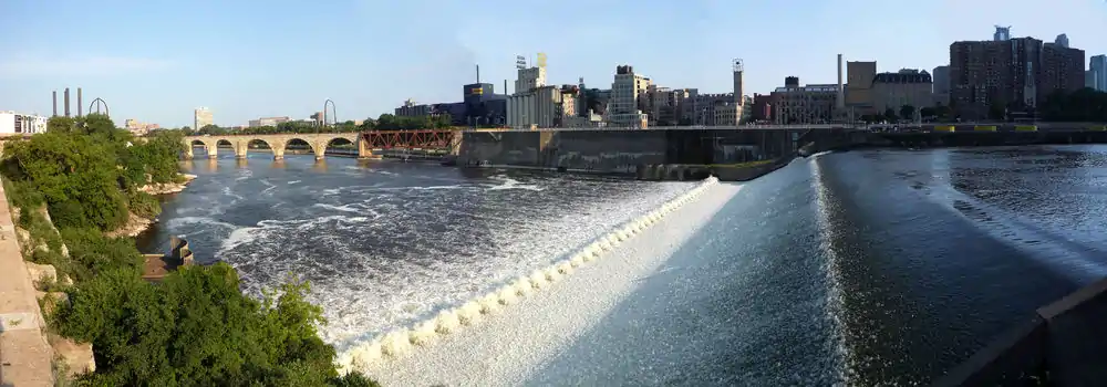
| St. Anthony Falls | 854 44°58′54″N 93°15′26″W | Federal | U.S. Army Corps of Engineers | N/A | 1937 | The only waterfall on the entire Mississippi powered a major milling district from the 1860s to the 1930s. In 1937 the falls were about to erode into rapids and were stabilized with a concrete spillway. |
| St. Croix National Scenic Riverway | 811.5 45°25′1″N 92°38′46″W | Federal | National Park Service | 92,738 acres (37,530 ha) | 1968 | A tributary of the Mississippi, the largely undeveloped St. Croix River on the Wisconsin–Minnesota border is protected as a separate unit of the National Park system. |
| Stone Arch Bridge | 853.9 44°58′50″N 93°15′11″W | City | Minneapolis Park and Recreation Board | 58,000 square feet (5,400 m2) | 1994 | Built in 1883 for James J. Hill's Great Northern Railway, this 2,100-foot-long (640 m) Historic Civil Engineering Landmark was converted to a walking and biking path in 1994. |
| Upper St. Anthony Falls Lock and Dam | 854 44°58′50″N 93°15′28″W | Federal | U.S. Army Corps of Engineers | N/A | 1963 | Free tours are offered of the facility that finally extended navigation above St. Anthony Falls. |
| Vento View Overlook | ~841.6 44°55′3″N 93°6′48″W | City | St. Paul Parks and Recreation | N/A | 2001[10] | Congressman Bruce Vento, a dedicated environmental advocate, is honored at this river valley overlook . Part of Cherokee Regional Park. |
| Vermillion River Bottoms | 795.5 | State | Minnesota Department of Natural Resources | The lower Vermillion River flows through floodplain forest before emptying into the Mississippi. | ||
| Water Power Park | ~853.8 44°59′3″N 93°15′17″W | City | Minneapolis Park and Recreation Board | 1.4 acres (0.57 ha) | 2007[9] | Interprets the country's first commercial hydroelectric power plant. |
| Winchell Trail | 44°56′35.87″N 93°12′9.87″W | City | Minneapolis Park and Recreation Board | N/A | 1914 | 5 mi (8 km) hiking trail off the West River Parkway in Minneapolis. |
See also
References
- "Mississippi National River and Recreation Area". Geographic Names Information System. United States Geological Survey. Retrieved 2012-12-05.
- "Listing of acreage as of December 31, 2011". Land Resource Division, National Park Service. Retrieved 2012-12-26.
- "Mississippi River Companion - Mississippi National River and Recreation Area". www.nps.gov. U.S. National Park Service. 2020-11-19.
- National Park Service (2011-02-16). "Mississippi National River and Recreation Area: Plan Your Visit". U.S. Department of the Interior. Retrieved 2011-03-25.
- National Park Service. "Mississippi River Companion". U.S. Department of the Interior. Cite journal requires
|journal=(help) - All data come from respective website or MNRRA "Plan Your Visit" page unless otherwise noted.
- Empson, Donald (2006). The Street Where You Live: A Guide to the Place Names of St. Paul. Minneapolis: University of Minnesota Press. ISBN 978-0-8166-4729-3.
- Smith, David C. (2008). "Parks, Lakes, Trails and So Much More: An Overview of the Histories of MPRB Properties" (PDF). Minneapolis Park and Recreation Board. Archived from the original (PDF) on 2011-02-06. Retrieved 2011-03-23.
- "History, nature intersect as St. Paul rediscovers an urban oasis". Friends of the Mississippi River. August 2008. Retrieved 2011-03-23.
- Coon Rapids Regional Dam Commission (2011-02-28). "Coon Rapids Regional Dam Commission Report". Retrieved 2011-03-26. Cite journal requires
|journal=(help) - "Grey Cloud Island Township". Washington County Communities. Washington County Historical Society. Archived from the original on 2011-08-07. Retrieved 2011-03-24.
- Saint Paul Parks & Recreation (January 1998). "A Guide to... Hidden Falls Regional Park". Cite journal requires
|journal=(help) - Furst, Randy (1987-06-26). "Grand openings planned for two riverfront parks". Star Tribune. Minneapolis, Minn.
- "Hastings River Flats Restoration". Friends of the Mississippi River. Retrieved 2011-03-25.
- Nelson, Tim (2007-08-24). "River history reclaimed: A new St. Paul park makes accessible the remains of the historic Meeker Island Lock and Dam". Saint Paul Pioneer Press. St. Paul, Minn.
- Jefferson, Jennifer (2003-08-04). "New center celebrates Mississippi River: Science Museum facility opens to public Saturday". Saint Paul Pioneer Press. St. Paul, Minn.
- "The Sibley House". Friends of the Sibley Historical Site. Retrieved 2011-03-23.
- Ferraro, Nick (2010-06-21). "History sleuths search buried dirt for clues of ancient people in Dakota County". Saint Paul Pioneer Press. St. Paul, Minn.
External links
| Wikimedia Commons has media related to Mississippi National River and Recreation Area. |
| Authority control |
|---|