National Trails System
The National Trails System was created by the National Trails System Act (Pub.L. 90–543, 82 Stat. 919, enacted October 2, 1968), codified at 16 U.S.C. § 1241 et seq.


The Act created a series of National trails "to promote the preservation of, public access to, travel within, and enjoyment and appreciation of the open-air, outdoor areas and historic resources of the Nation." Specifically, the Act authorized three types of trails: the National Scenic Trails, National Recreation Trails and connecting and side trails. The 1968 Act also created two national scenic trails: the Appalachian and the Pacific Crest; and requested that an additional fourteen trail routes be studied for possible inclusion.
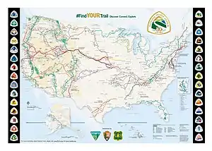
In 1978, as a result of the study of trails that were most significant for their historic associations, a fourth category of trail was added: the National Historic Trails. Since 1968, over forty trail routes have been studied for inclusion in the system. Of these studied trails, twenty-one have been established as part of the system. Today, the National Trails System consists of 30 National Scenic and Historic Trails and over 1,000 National Recreation Trail and two connecting and side trails, with a total length of more than 50,000 miles (80,000 km). These National Trails are more than just for hiking, many are also open for horseback riding, mountain biking, camping and/or scenic driving.
As Congressionally established long-distance trails, each one is administered by a federal agency, either the Bureau of Land Management, United States Forest Service, or National Park Service. Two of the trails are jointly administered by the BLM and the NPS. Occasionally, these agencies acquire lands to protect key sites, resources and viewsheds. More often than not, they work in partnership with the states, local units of government, land trusts and private landowners, to protect lands and structures along these trails, enabling them to be accessible to the public. National Recreation Trails and connecting and side trails do not require Congressional action, but are recognized by actions of the Secretary of the Interior or the Secretary of Agriculture. All of the National Trails are supported by private non-profit organizations that work with the various federal agencies under the Partnership for the National Trails System (PNTS).
The Act is codified as 16 U.S.C. §§ 1241–1251. However, it has been amended numerous times since its passage,[1] most recently on October 18, 2004 (Pub.L. 108–342 (text) (pdf)).[2]
National Scenic Trails
National Scenic Trails were established to provide outdoor recreation opportunities and to conserve portions of the natural landscape with significant scenic, historic, natural, or cultural importance.[3] Most notably, the National Scenic Trail system provides access to the crest of the Appalachian Mountains in the east via the Appalachian Trail, to the Rocky Mountains of the west on the Continental Divide Trail, and to the Cascade and Sierra Nevada ranges on the Pacific Crest Trail. Other places of note include the southern wetlands and Gulf Coast on the Florida Trail, the North Woods on the North Country Trail, and the wide variety of southwestern mountain ranges and ecosystems on the Arizona National Scenic Trail. Of the eleven national scenic trails,[4] Appalachian, Natchez Trace, and Potomac Heritage are official units of the NPS.
| Trail name | Year established | Length authorized (miles) | States on route |
|---|---|---|---|
| North Country National Scenic Trail | 1980 | 4,600 | Vermont, New York, Pennsylvania, Ohio, Michigan, Wisconsin, Minnesota, North Dakota |
| Continental Divide National Scenic Trail | 1978 | 3,100 | Montana, Idaho, Wyoming, Colorado, New Mexico |
| Pacific Crest National Scenic Trail | 1968 | 2,650[5] | California, Oregon, Washington |
| Appalachian National Scenic Trail | 1968 | 2,181[6] | Georgia, North Carolina, Tennessee, Virginia, West Virginia, Maryland, Pennsylvania, New Jersey, New York, Connecticut, Massachusetts, Vermont, New Hampshire, Maine |
| Florida National Scenic Trail | 1983 | 1,300 | Florida |
| Ice Age National Scenic Trail | 1980 | 1,200 | Wisconsin |
| Pacific Northwest National Scenic Trail | 2009 | 1,200 | Montana, Idaho, Washington |
| Arizona National Scenic Trail | 2009 | 807 | Arizona |
| Potomac Heritage National Scenic Trail | 1983 | 700 | Virginia, Maryland, Pennsylvania, District of Columbia |
| Natchez Trace National Scenic Trail | 1983 | 695 | Tennessee, Alabama, Mississippi |
| New England National Scenic Trail | 2009 | 220 | Massachusetts, Connecticut |
| Total: | 18,734 |
National Historic Trails
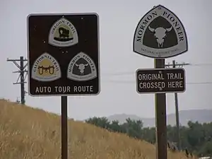
National Historic Trails are designated to protect the remains of significant overland or water routes to reflect the history of the nation. They represent the earliest travels across the continent on the Juan Bautista de Anza National Historic Trail; the nation's struggle for independence on the Overmountain Victory National Historic Trail; epic migrations on the Mormon & Oregon Trails and the development of continental commerce on the Santa Fe Trail. They also commemorate the forced displacement and hardships of the Native Americans, on the Trail of Tears. There are 19 Historic Trails.[7] Most of them are scenic routes instead of non-motorized trails.
National Historic Trails were authorized under the National Parks and Recreation Act of 1978 (Public Law 95-625),[8] amending the National Trails System Act of 1968 (Public Law 90-543)
| Trail name | Year established | Length authorized | States on route |
|---|---|---|---|
| Oregon National Historic Trail | 1978 | 2,170 miles (3,490 km) | Iowa, Missouri, Kansas, Nebraska, Wyoming, Idaho, Oregon |
| Mormon Pioneer National Historic Trail | 1978 | 1,300 miles (2,100 km) | Illinois, Iowa, Nebraska, Wyoming, Utah |
| Lewis and Clark National Historic Trail | 1978 | 3,700 miles (6,000 km) | Illinois, Missouri, Kansas, Iowa, Nebraska, South Dakota, North Dakota, Montana, Idaho, Oregon, Washington. |
| Iditarod National Historic Trail | 1978 | 2,350 miles (3,780 km) | Alaska |
| Overmountain Victory National Historic Trail | 1980 | 275 miles (443 km) | Tennessee, North Carolina, South Carolina |
| Nez Perce National Historic Trail | 1986 | 1,170 miles (1,880 km) | Oregon, Idaho, Wyoming, Montana |
| Santa Fe National Historic Trail | 1987 | 1,203 miles (1,936 km) | Missouri, Kansas, Oklahoma, Texas, New Mexico, Colorado |
| Trail of Tears National Historic Trail | 1987 | 2,200 miles (3,500 km) | Georgia, North Carolina, Tennessee, Alabama, Kentucky, Illinois, Missouri, Arkansas, Oklahoma |
| Juan Bautista de Anza National Historic Trail | 1990 | 1,200 miles (1,900 km) | Arizona, California |
| California Trail | 1992 | 5,665 miles (9,117 km) | Missouri, Kansas, Nebraska, Colorado, Wyoming, Idaho, Utah, Nevada, California, Oregon |
| Pony Express National Historic Trail | 1992 | 1,966 miles (3,164 km) | California, Colorado,Kansas, Missouri, Nebraska, Nevada,Utah, Wyoming, |
| Selma to Montgomery National Historic Trail | 1996 | 54 miles (87 km) | Alabama |
| El Camino Real de Tierra Adentro National Historic Trail | 2000 | 404 miles (650 km) | New Mexico |
| Ala Kahakai National Historic Trail | 2000 | 175 miles (282 km) | Hawaii |
| Old Spanish National Historic Trail | 2002 | 2,700 miles (4,300 km) | New Mexico, Colorado, Utah, Arizona, Nevada, California |
| El Camino Real de los Tejas National Historic Trail | 2004 | 2,580 miles (4,150 km) | Texas, Louisiana |
| Captain John Smith Chesapeake National Historic Trail | 2006 | 3,000 miles (4,800 km) | Delaware, Maryland, Virginia, District of Columbia |
| Star-Spangled Banner National Historic Trail | 2008 | 290 miles (470 km) | Maryland, Virginia, District of Columbia |
| Washington-Rochambeau Revolutionary Route National Historic Trail | 2009 | 600 miles (970 km) | Massachusetts, Rhode Island, Connecticut, New York, New Jersey, Pennsylvania, Maryland, Delaware, Virginia, District of Columbia |
| Total: | 33,002 miles (53,112 km) |
National Connecting and Side Trails
The act also established a category of trails known as connecting and side trails. To date, only two national side trails have been designated, both in 1990: The ten-mile Timms Hill Trail, which connects the Ice Age Trail to Wisconsin's highest point, Timms Hill, and the 86-mile Anvik Connector, which joins the Iditarod Trail to the village of Anvik, Alaska.[9]
- Timms Hill Trail
- Anvik Connector
National Geologic Trail
The first National Geologic Trail was established by the Omnibus Public Land Management Act of 2009.
See also
Notes and references
- Notes on 16 U.S.C. § 1241-1251
- The Act, from the National Park Service
- "History of the National Trails System - American Trails". www.americantrails.org. Retrieved 2020-04-08.
- National Trails System brochure, National Park Service & Bureau of Land Management, Dept. of Interior; and the Forest Service, Dept. of Agriculture
- "PCT FAQ - Pacific Crest Trail Association". pcta.org. Retrieved 5 April 2018.
- "Appalachian Trail Conservancy Puts New Official Length of the Appalachian Trail at 2,181.0 Miles". www.appalachiantrail.org. Retrieved 5 April 2018.
- National Trails System, National Park Service & Bureau of Land Management, Dept. of Interior; and the Forest Service, Dept. of Agriculture
- Notes on 16 U.S.C. §1244
- About.com article on National Trails system Archived 2015-04-05 at the Wayback Machine
Further reading
- Karen Berger, Bill McKibben (foreword) & Bart Smith (photography): America's Great Hiking Trails: Appalachian, Pacific Crest, Continental Divide, North Country, Ice Age, Potomac Heritage, Florida, Natchez Trace, Arizona, Pacific Northwest, New England. Rizzoli, 2014, ISBN 978-0789327413
External links
| Wikivoyage has a travel guide for United States National Trails System. |
| Wikimedia Commons has media related to National Trails of the United States. |