Arkansas Highway 176
Arkansas Highway 176 (AR 176, Ark. 176, and Hwy. 176) is the designation for a state highway which is located in Central Arkansas. The highway is split into two sections. The first section begins at Interstate 40 (I-40) and AR 365 in North Little Rock and ends at Camp Robinson Road and Remount Road in North Little Rock. The second section begins at AR 107 in Sherwood and ends at Rixie Road in Sherwood. AR 176 also has a spur route (signed as Highway 176Y or AR 176Y), which intersects US Route 67/US Route 167 (US 67/US 167) southbound.[1]
| ||||
|---|---|---|---|---|
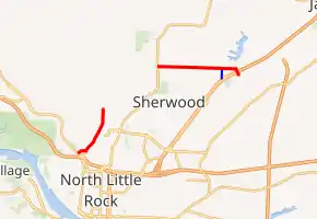
AR 176 in red, AR 176Y in blue | ||||
| Route information | ||||
| Maintained by ArDOT | ||||
| Section 1 | ||||
| Length | 2.0 mi (3.2 km) | |||
| West end | ||||
| East end | Intersection of Camp Robinson Road and Remount Road | |||
| Section 2 | ||||
| Length | 3.1 mi (5.0 km) | |||
| West end | ||||
| Major junctions | ||||
| East end | Rixie Road in Sherwood | |||
| Location | ||||
| Counties | Pulaski | |||
| Highway system | ||||
| ||||

Route description
Camp Robinson Road (North Little Rock route)
AR 176 begins at I-40 (via exit 152B westbound) and AR 365 in North Little Rock, in the Levy subdivision. The route heads north, before intersecting Camp Robinson Road. AR 176 follows Camp Robinson Road for about two miles (3.2 km) before reaching its eastern terminus at the intersection of Remount Road and Camp Robinson Road.
Kiehl Avenue (Sherwood route)
AR 176 begins at AR 107 in Sherwood. The route heads east for about three miles (4.8 km) before intersecting US 67/US 167 northbound. The route ends at Rixie Road in Sherwood, shortly after its intersection with US 67/US 167. The route itself is locally referred to as Kiehl Avenue for its entire length.
Major intersections
The entire route is in Pulaski County.
| Location | mi | km | Destinations | Notes | |||
|---|---|---|---|---|---|---|---|
| North Little Rock | 0.0 | 0.0 | Western terminus | ||||
| 2.0 | 3.2 | Remount Road | Eastern terminus | ||||
| Gap in route | |||||||
| Sherwood | 0.0 | 0.0 | Western terminus | ||||
| 2.3 | 3.7 | AR 176Y northern terminus | |||||
| 3.1 | 5.0 | US 67 / US 167 exit 5; access via frontage roads | |||||
| 3.2 | 5.1 | Rixie Road | Eastern terminus | ||||
| 1.000 mi = 1.609 km; 1.000 km = 0.621 mi | |||||||
Spur route
| |
|---|---|
| Location | Sherwood |
| Length | 0.38 mi (0.61 km) |
Highway 176Y (AR 176Y, Ark. 176Y, Hwy. 176Y) is a very short spur route which connects AR 176 with US 67/US 167 southbound frontage road. The route is accessible via exit 4 northbound.
External links
 Media related to Arkansas Highway 176 at Wikimedia Commons