List of Interstate Highways in Arkansas
The list of Interstate Highways in Arkansas encompasses nine members of the Dwight D. Eisenhower National System of Interstate and Defense Highways in the state of Arkansas.
.svg.png.webp) .svg.png.webp) Highway markers for Interstate 40 and Interstate 555 | |
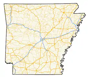 A map of highways in the state of Arkansas | |
| System information | |
|---|---|
| Formed | 1956 |
| Highway names | |
| Interstates | Interstate nn (I-nn) |
| System links | |
Cable median barriers
The 2010–2013 Statewide Transportation Improvement Program from the Arkansas State Highway and Transportation Department (AHTD) lists cable median barrier installation projects along segments of Interstate 30,[1] Interstate 40,[2] Interstate 55,[2] Interstate 430,[2] and Interstate 540[3] (also US 67 {Future Interstate 57} from Cabot to Jacksonville)[4] to begin as funds become available. The high-tension designs will first be installed in areas with narrow medians (less than 40 feet (12 m) wide) that carry an average daily traffic of 15,000 or greater near sites of recent serious crossover collisions.
Primary Interstates
| Number | Length (mi)[5] | Length (km) | Southern or western terminus | Northern or eastern terminus | Formed | Removed | Notes | |
|---|---|---|---|---|---|---|---|---|
| 143.02 | 230.17 | I-30 at the Texas state line | I-40 at Little Rock | 1957 | current | Goes through Hope, Arkadelphia, Benton, and Little Rock | ||
| 284.69 | 458.16 | I-40 at the Oklahoma state line | I-40 at the Tennessee state line | 1964 | current | Goes through Van Buren, Russellville, Conway, North Little Rock, ends at Hernando de Soto Bridge crossing the Mississippi River | ||
| 109.81 | 176.72 | I-49 at the Louisiana state line | I-49 at the Missouri state line | 2014 | current | |||
| 72.22 | 116.23 | I-55 at the Tennessee state line | I-55 at the Missouri state line | 1960 | current | Parallels the Mississippi River | ||
| — | — | I-40 in Little Rock | I-57 at the Missouri state line | proposed[6] | — | Future route along US 67 | ||
| 185 | 298 | I-69 at the Louisiana state line | I-69/US 278 at the Mississippi state line | proposed | — | Monticello Bypass currently under construction; proposed to head northeast between Magnolia and El Dorado then proposed to head north near Louann then proposed to head east and go south of Camden, Harrell, Warren, Wilmar, and Monticello, where it will meet the I-530 extension, then proposed to go north of McGehee then proposed to go south of Arkansas City then proposed to end at Charles W. Dean Bridge, which will cross the Mississippi River | ||
| ||||||||
Auxiliary Interstates
| Number | Length (mi)[5] | Length (km) | Southern or western terminus | Northern or eastern terminus | Formed | Removed | Notes | |
|---|---|---|---|---|---|---|---|---|
| 5.8 | 9.3 | US 71 in Texarkana | I-30 in Texarkana | 2000 | 2014 | I-130 was a planned spur route for the Texarkana loop east of the Texas state line. It is now signed as I-49 | ||
| 12.93 | 20.81 | I-30 at Little Rock | I-40 near North Little Rock | c. 1980 | current | Bypasses Little Rock and North Little Rock | ||
| 9.96 | 16.03 | I-30 at Little Rock | I-40 in North Little Rock | 2003 | current | Connects I-40 with I-30 and I-530 | ||
| 46.65 | 75.08 | I-69 at Pine Bluff | I-30 in Little Rock | 1999 | current | Will connect to Future I-69 | ||
| 15.87 | 25.54 | US 71 near Fort Smith | I-40 in Van Buren | 1965 | current | North portion became part of I-49 | ||
| 49.2 | 79.2 | I-55 near Turrell | US 49/AR 18 at Jonesboro | 2016 | current | Continues north as US 63 | ||
| 7.40 | 11.91 | I-430 in Little Rock | I-30 in Little Rock | 1985 | current | |||
| ||||||||
References
- Arkansas State Highway and Transportation Department (April 12, 2010). "Arkansas Statewide Transportation Improvement Program (STIP)" (PDF) (Report). Little Rock: Arkansas State Highway and Transportation Department. p. 22. Retrieved June 16, 2011.
- Oman, Noel E. (June 6, 2011). "13 Interstate Stretches to Get Barriers". Arkansas Democrat-Gazette. Little Rock. pp. 1B, 8B. Retrieved June 16, 2011.
- Arkansas State Highway and Transportation Department (April 12, 2010). "Arkansas Statewide Transportation Improvement Program (STIP)" (PDF) (Report). Little Rock: Arkansas State Highway and Transportation Department. p. 35. Retrieved June 16, 2011.
- Arkansas State Highway and Transportation Department (April 12, 2010). "Arkansas Statewide Transportation Improvement Program (STIP)" (PDF) (Report). Little Rock: Arkansas State Highway and Transportation Department. p. 26. Retrieved June 16, 2011.
- Adderly, Kevin (December 31, 2014). "Table 3: Interstate Routes in Each of the 50 States, District of Columbia, and Puerto Rico". Route Log and Finder List. Federal Highway Administration. Retrieved December 3, 2015.
- https://route.transportation.org/wp-content/uploads/sites/50/2017/06/USRN-01-Minutes-and-Application-results_-AM-Phoenix-2017.pdf