Arkansas Highway 352
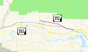
Highway 352 (AR 352, Ark. 352, and Hwy. 352) is a designation for two east–west state highways in the Arkansas River Valley. One section begins at Franklin County Road 441 (CR 441) and runs north 1.11 miles (1.79 km) to US Highway 64 (US 64). A second segment begins at Highway 23 approximately 5 miles (8.0 km) north of Ozark. Its eastern terminus is U.S. Highway 64 in Clarksville.
| ||||
|---|---|---|---|---|
 | ||||
| Route information | ||||
| Maintained by ArDOT | ||||
| Existed | November 23, 1966[1]–present | |||
| Section 1 | ||||
| Length | 1.11 mi[2] (1.79 km) | |||
| West end | ||||
| East end | ||||
| Section 2 | ||||
| Length | 21.43 mi[2] (34.49 km) | |||
| West end | ||||
| East end | ||||
| Location | ||||
| Counties | Franklin, Johnson | |||
| Highway system | ||||
| ||||
Route description
Western Franklin County
The highway begins at Franklin CR 441 and runs due north as a section line road to US 64 in western Franklin County.[3]
White Oak to Clarksville
The route begins at Highway 23 north of Ozark in the Arkansas River Valley. The route is a two-lane rural highway its complete length, paralleling Interstate 40 (I-40) and bridging it twice, though no direct access to I-40 is provided.
Highway 352 begins at AR 23 and runs east to meet AR 219 in Mountain Grove. It continues east, meeting AR 164 in Hunt before angling south to cross over I-40. The route runs south of I-40 until it again crosses over the road, after which it terminates at US 64 in Clarksville.[4]
History
Two sections of Highway 352 were created by the Arkansas State Highway Commission on November 23, 1966; one between Highway 23 and Highway 219 in Franklin County and one from US 64 near Clarksville west to a county road at Borden's Corner.[1] In 1973, the Arkansas General Assembly passed Act 9 of 1973. The act directed county judges and legislators to designate up to 12 miles (19 km) of county roads as state highways in each county.[5] As a result of this legislation, a third segment of Highway 352 was designated on April 25, 1973 (running south from US 64),[6] and the segment in Johnson County was extended west to the Franklin County line on May 23, 1973.[7] The gap between the two longer routes was closed on October 31, 1973, but this gap closure was initially part of an extended Highway 186.[8] The Highway 186 segment between the two Highway 352 sections was renumbered to provide route continuity on August 25, 1976.[9]
Major intersections
| County | Location | mi[2] | km | Destinations | Notes | ||
|---|---|---|---|---|---|---|---|
| Franklin | | 0.00 | 0.00 | Western terminus | |||
| | 1.11 | 1.79 | Eastern terminus | ||||
| Gap in route | |||||||
| White Oak | 0.00 | 0.00 | Western terminus | ||||
| Mountain Grove | 3.19 | 5.13 | |||||
| Johnson | | 5.76– 5.96 | 9.27– 9.59 | officially designated exception | |||
| Clarksville | 21.43 | 34.49 | Eastern terminus | ||||
1.000 mi = 1.609 km; 1.000 km = 0.621 mi
| |||||||
See also
References
- "Minutes of the Meeting" (PDF). Arkansas State Highway Commission. 1953–69. p. 559. Retrieved December 16, 2016.
- System Information and Research Division (2014). "Arkansas Road Log Database" (MDB). Arkansas State Highway and Transportation Department. Retrieved March 27, 2016.
- Arkansas State Highway and Transportation Department (May 19, 2010). General Highway Map, Franklin County, Arkansas (PDF) (Map). 1:62500. Arkansas State Highway and Transportation Department. Retrieved December 16, 2016.
- Arkansas State Highway and Transportation Department (February 10, 2012). General Highway Map, Johnson County, Arkansas (PDF) (Map). 1:62500. Arkansas State Highway and Transportation Department. Retrieved December 16, 2016.
- Planning and Research Division, Policy Analysis Section (2010). Development of Highway and Transportation Legislation in Arkansas (PDF). A Review of the Acts Relative to Administering and Financing Highways and Transportation in Arkansas. Little Rock: Arkansas State Highway and Transportation Department. p. 13. Retrieved December 4, 2016.
- "Minutes" (1970–79), p. 1139.
- "Minutes" (1970–79), p. 1166-1167.
- "Minutes" (1970–79), p. 1017.
- "Minutes" (1970–79), p. 707.
- "Minutes of the Meeting" (PDF). Arkansas State Highway Commission. 1970–79. Retrieved December 16, 2016.
External links
![]() Media related to Arkansas Highway 352 at Wikimedia Commons
Media related to Arkansas Highway 352 at Wikimedia Commons
