Arkansas Highway 400
Arkansas Highway 400 (AR 400), also known as Shepherd Springs Road, is a short state highway in Crawford County. At just over 2 miles (3.2 km), it serves as the entrance road for Lake Fort Smith State Park from U.S. Route 71 (US 71).
| ||||
|---|---|---|---|---|
| ||||
| Route information | ||||
| Maintained by ArDOT | ||||
| Length | 2.05 mi[1] (3.30 km) | |||
| Major junctions | ||||
| West end | ||||
| East end | Lake Fort Smith State Park | |||
| Location | ||||
| Counties | Crawford | |||
| Highway system | ||||
| ||||

Route description
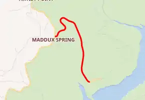
Highway 400 begins at US 71 northeast of Chester. The route passes through the rugged terrain of the Ozark National Forest. The highway descends down a steep hill, this section of road features a hairpin turn. It continues to descend the hill until it reaches the entrance to Lake Fort Smith State Park, where the designation ends.[1]
Major intersections
The entire route is in Crawford County.
| Location | mi[1] | km | Destinations | Notes | |
|---|---|---|---|---|---|
| | 0.00 | 0.00 | |||
| | 2.05 | 3.30 | Lake Fort Smith State Park entrance | ||
| 1.000 mi = 1.609 km; 1.000 km = 0.621 mi | |||||
References
- Route and Section Map (PDF) (Map). Crawford County. Arkansas State Highway and Transportation Department. Retrieved May 11, 2011.
External links
This article is issued from Wikipedia. The text is licensed under Creative Commons - Attribution - Sharealike. Additional terms may apply for the media files.