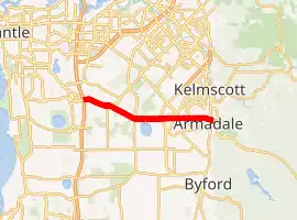
Armadale Road
Armadale Road is a major road in the south and south east of the Perth Metropolitan Area. It serves three purposes: firstly, providing a main route from Armadale to Fremantle; secondly, connecting Armadale to the Kwinana Freeway; and thirdly, since 2005, connecting it to the Tonkin Highway which ferries traffic to the eastern suburbs, Perth Airport and the Forrestfield and Kewdale industrial areas.
Armadale Road | |
|---|---|
| |
| General information | |
| Type | Road |
| Length | 16.2 km (10 mi) |
| Route number(s) | |
| Major junctions | |
| East end | |
| |
| West end | |
| Location(s) | |
| Major suburbs | Armadale, Brookdale, Forrestdale, Banjup, Atwell |
It commences at the Albany Highway/South Western Highway intersection in central Armadale, and follows the dismantled Spearwood-Armadale railway line west then northwest for 16.2 kilometres (10.1 mi) to terminate at the Kwinana Freeway/Beeliar Drive intersection in Cockburn Central. The road is signed as State Route 14 for its entire length.
History
Until the Kwinana Freeway extension in the early 1990s, Armadale Road terminated in Forrestdale. At this time, Forrest Road was the main road from Hamilton Hill to Armadale. The realignment of Forrest Road, as the Kwinana Freeway was extended, saw it renamed as Armadale Road up to the freeway (with most of the remainder of the old Forrest Road being renamed North Lake Road).
Prior to 2003, Armadale Road was a single carriageway from Lake Road in Forrestdale, to Solomon Road near the freeway. However, as part of the Tonkin Highway extension from 2003 to 2005, Armadale Road was upgraded to a dual carriageway from Lake Road to Anstey Road. This was done in anticipation of the large volumes of traffic expected due to the extension.[2]
Current upgrades
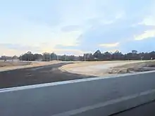
Following the 2017 election of Western Australian Labor to the state parliament, the controversial Perth Freight Link project was cancelled. This allowed for a new Commonwealth-State agreement to be reached, which would allow for $2.3 billion of funding to be relocated to other road projects. Two of these projects were the $145 million Armadale Road dual carriage upgrade between Anstey Road and Tapper Road,[3] as well as the $237 million North Lake Road bridge over Kwinana Freeway.[4][5]
Anstey Road to Tapper Road
Work commenced on 7 March 2018, with Premier Mark McGowan, Federal Minister for Urban Infrastructure and Cities Paul Fletcher and State Transport Minister Rita Saffioti turning the first sod on the project.[6] It was completed by February 2020.
The project involved the widening of the road to a dual carriageway.[7] The intersection with Nicholson Road, one of the state's worst black spots, was upgraded to a bridge over a roundabout with the bridge named the Hugo Throssell VC Bridge after the late Victoria Cross Recipient. A shared path for pedestrians and cyclists was built adjacent to the road, with various facilities being installed along the length of the road. This was opened in March 2020.[8] The upgrade also delivered new roundabouts at the intersection with Liddelow Road and at the intersection with Taylor Road and Wright Road, as well as upgrades at the Ghostgum Avenue intersection.
Armadale Road to North Lake Road Bridge
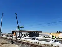
This project involves the construction of a bridge over Kwinana Freeway with north-facing on and off ramps, connecting Armadale Road to North Lake Road. This will remove another one of the state's black spots, the Beeliar Drive / Midgegooroo Avenue intersection, reduce congestion on the Kwinana Freeway interchange, and improve access to Cockburn Central railway station. Grade separated roundabouts will be constructed at Tapper Road / Verde Drive and at a new Beeliar Drive / Solomon Road intersection.
This project will link with the Kwinana Freeway northbound widening from Russell Road to Roe Highway, as well as the Armadale Road widening. Construction is expected to begin in late 2018 / early 2019, with completion sometime in 2021.[9]
Major intersections
| LGA | Location | km | mi | Destinations | Notes |
|---|---|---|---|---|---|
| Armadale | Armadale | 0 | 0.0 | Traffic light intersection; Armadale Road continues as Albany Highway east of this point | |
| 0.3 | 0.19 | Church Avenue | |||
| 0.5 | 0.31 | Orchard Avenue | |||
| 0.9 | 0.56 | Abbey Road south-west / Railway Avenue north-east – Brookdale, Kelmscott | Traffic light intersection | ||
| 2.5 | 1.6 | Seventh Road | |||
| Armadale – Seville Grove boundary | 2.9 | 1.8 | Seville Drive – Seville Grove | Traffic light intersection | |
| Armadale–Seville Grove–Haynes tripoint | 3.6 | 2.2 | Eighth Road | ||
| Seville Grove–Haynes–Forrestdale tripoint | 4.6 | 2.9 | Roundabout | ||
| Forrestdale | 5.3 | 3.3 | Alex Wood Drive | ||
| 6.2 | 3.9 | Traffic light intersection | |||
| 8.0 | 5.0 | Anstey Road north / Weld Street south | Roundabout | ||
| Forrestdale – Piara Waters boundary | 9.4 | 5.8 | Roundabout interchange favouring Armadale Road. Overpass known as the Hugo Throssell VC Bridge | ||
| 11.1 | 6.9 | Taylor Road south / Wright Road north – Harrisdale | Roundabout | ||
| Armadale – Cockburn boundary | Forrestdale–Piara Waters–Treeby–Banjup quadripoint | 12.1 | 7.5 | Warton Road – Southern River, Gosnells | Traffic light intersection |
| Cockburn | Treeby – Banjup boundary | 13.1 | 8.1 | Liddelow Road | Roundabout |
| 14.2 | 8.8 | Ghostgum Avenue | Traffic light intersection | ||
| Banjup–Atwell–Jandakot tripoint | 14.9 | 9.3 | Tapper Road south / Verde Drive north – Atwell, Aubin Grove | Traffic light intersection | |
| Atwell – Jandakot boundary | 15.4 | 9.6 | Solomon Road | Provides access to Cockburn Central railway station | |
| 15.6 | 9.7 | Freshwater Drive | |||
| Cockburn Central–Jandakot–Atwell–Success quadripoint | 15.9 | 9.9 | Diamond interchange; westbound terminus: continues as Beeliar Drive | ||
| 1.000 mi = 1.609 km; 1.000 km = 0.621 mi | |||||
Speed limits
The road has speed limits of 70 kilometres per hour (43 mph) between the Kwinana Freeway and Tapper Road in Atwell, and between the Armadale railway line and Albany Highway; all other sections (apart from a short distance either side of the Nicholson Road intersection) are signed 80 kilometres per hour (50 mph).
See also
![]() Australian Roads portal
Australian Roads portal
References
- Distance book (12 ed.). Main Roads Western Australia. 2012. pp. 4–5. ISBN 0 7309 7657 2. Archived from the original on 24 October 2012. Retrieved 21 December 2013.
- "Armadale Road – Construct dual carriageway from Anstey Road to Tapper Road" (PDF). Main Roads Western Australia. p. 7. Archived from the original (PDF) on 17 December 2018. Retrieved 17 December 2018.
- "Roe 8 Alliance redeployed to three new projects". Media Statements. Government of Western Australia. 10 May 2017. Archived from the original on 17 December 2018. Retrieved 17 December 2018.
- "Armadale Road to North Lake Road Bridge". Main Roads Western Australia. Government of Western Australia. 14 December 2018. Archived from the original on 17 December 2018. Retrieved 17 December 2018.
- "Armadale Road to North Lake Road Bridge Fact Sheet" (PDF). Main Roads Western Australia. Government of Western Australia. Archived from the original (PDF) on 17 December 2018. Retrieved 17 December 2018.
- "Work starts on major Armadale Road upgrade". Ministers for the Department of Infrastructure, Regional Development and Cities. Archived from the original on 17 December 2018. Retrieved 17 December 2018.
- "Armadale Road Upgrade - Tapper Road to Anstey Road". Main Roads Western Australia. Government of Western Australia. Archived from the original on 17 December 2018. Retrieved 17 December 2018.
- "Work starts on $145m Armadale Road upgrade in Perth". Urbanalyst. 12 March 2018. Archived from the original on 17 December 2018. Retrieved 17 December 2018.
- Cipriano, Belinda (14 March 2018). "Sod turning marks the start of Armadale Road upgrades". Cockburn Gazette. Community News. Archived from the original on 17 December 2018. Retrieved 17 December 2018.
| |||
| National Highways | |||
| National Routes | |||
| State Routes | |||
| Tourist Drives | |||