Arrondissement of Metz
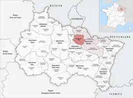
The arrondissement of Metz is an arrondissement of France in the Moselle department in the Grand Est region. It has 139 communes.[1] Its population is 344,203 (2016), and its area is 1,088.7 km2 (420.3 sq mi).[2]
Metz | |
|---|---|
 Location within the region Grand Est | |
| Country | France |
| Region | Grand Est |
| Department | Moselle |
| No. of communes | 139 |
| Prefecture | Metz |
| Area | |
| • Total | 1,088.7 km2 (420.3 sq mi) |
| Population (2016) | |
| • Total | 344,203 |
| • Density | 316/km2 (820/sq mi) |
| INSEE code | 579 |
| Part of the series on |
| Lorraine |
|---|
 |
Composition
The communes of the arrondissement of Metz are:[1]
- Amanvillers
- Amnéville
- Ancerville
- Ancy-Dornot
- Antilly
- Argancy
- Arry
- Ars-Laquenexy
- Ars-sur-Moselle
- Aube
- Augny
- Ay-sur-Moselle
- Le Ban-Saint-Martin
- Bazoncourt
- Béchy
- Beux
- Bronvaux
- Buchy
- Burtoncourt
- Chailly-lès-Ennery
- Chanville
- Charleville-sous-Bois
- Charly-Oradour
- Châtel-Saint-Germain
- Cheminot
- Chérisey
- Chesny
- Chieulles
- Coincy
- Coin-lès-Cuvry
- Coin-sur-Seille
- Colligny-Maizery
- Corny-sur-Moselle
- Courcelles-Chaussy
- Courcelles-sur-Nied
- Cuvry
- Ennery
- Les Étangs
- Failly
- Fèves
- Féy
- Fleury
- Flévy
- Flocourt
- Foville
- Glatigny
- Goin
- Gorze
- Gravelotte
- Hagondange
- Hauconcourt
- Hayes
- Jouy-aux-Arches
- Jury
- Jussy
- Laquenexy
- Lemud
- Lessy
- Liéhon
- Longeville-lès-Metz
- Lorry-lès-Metz
- Lorry-Mardigny
- Louvigny
- Luppy
- Maizeroy
- Maizières-lès-Metz
- Malroy
- Marange-Silvange
- Marieulles
- Marly
- Marsilly
- La Maxe
- Mécleuves
- Metz
- Mey
- Moncheux
- Montigny-lès-Metz
- Montois-la-Montagne
- Moulins-lès-Metz
- Noisseville
- Norroy-le-Veneur
- Nouilly
- Novéant-sur-Moselle
- Ogy-Montoy-Flanville
- Orny
- Pagny-lès-Goin
- Pange
- Peltre
- Pierrevillers
- Plappeville
- Plesnois
- Pommérieux
- Rombas
- Pontoy
- Pouilly
- Pournoy-la-Chétive
- Pournoy-la-Grasse
- Raville
- Rémilly
- Retonfey
- Rezonville-Vionville
- Roncourt
- Rozérieulles
- Sailly-Achâtel
- Sainte-Barbe
- Sainte-Marie-aux-Chênes
- Sainte-Ruffine
- Saint-Hubert
- Saint-Julien-lès-Metz
- Saint-Jure
- Saint-Privat-la-Montagne
- Sanry-lès-Vigy
- Sanry-sur-Nied
- Saulny
- Scy-Chazelles
- Secourt
- Semécourt
- Servigny-lès-Raville
- Servigny-lès-Sainte-Barbe
- Sillegny
- Silly-en-Saulnois
- Silly-sur-Nied
- Solgne
- Sorbey
- Talange
- Thimonville
- Tragny
- Trémery
- Vantoux
- Vany
- Vaux
- Vernéville
- Verny
- Vigny
- Vigy
- Villers-Stoncourt
- Vry
- Vulmont
- Woippy
History
The arrondissement of Metz was created in 1800 and disbanded in 1871 (ceded to Germany).[3] The arrondissement of Metz was restored in January 2015 by the merger of the former arrondissements of Metz-Campagne and Metz-Ville.[4]
References
- "Arrondissement de Metz (579)". INSEE. Retrieved 2019-10-02.
- "Comparateur de territoire, géographie au 01/01/2019". INSEE. Retrieved 2019-10-02.
- Historique de la Moselle
- Décret n° 2014-1721 du 29 décembre 2014 portant suppression des arrondissements de Boulay-Moselle, de Château-Salins, de Thionville-Ouest et de Metz-Campagne (département de la Moselle)
This article is issued from Wikipedia. The text is licensed under Creative Commons - Attribution - Sharealike. Additional terms may apply for the media files.