Arrondissement of Pontarlier
The arrondissement of Pontarlier is an arrondissement of France in the Doubs department in the Bourgogne-Franche-Comté region. It has 149 communes.[1] Its population is 112,913 (2016), and its area is 2,050.5 km2 (791.7 sq mi).[2]
Pontarlier | |
|---|---|
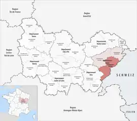 Location within the region Bourgogne-Franche-Comté | |
| Country | France |
| Region | Bourgogne-Franche-Comté |
| Department | Doubs |
| No. of communes | 149 |
| Subprefecture | Pontarlier |
| Area | |
| • Total | 2,050.5 km2 (791.7 sq mi) |
| Population (2016) | |
| • Total | 112,913 |
| • Density | 55/km2 (140/sq mi) |
| INSEE code | 253 |
Composition
Cantons
The cantons of the arrondissement of Pontarlier are:
- Frasne
- Morteau
- Ornans (partly)
- Pontarlier
- Valdahon (partly)
Communes
The communes of the arrondissement of Pontarlier, and their INSEE codes, are:[1]
- Adam-lès-Vercel (25007)
- Les Alliés (25012)
- Arçon (25024)
- Arc-sous-Cicon (25025)
- Arc-sous-Montenot (25026)
- Aubonne (25029)
- Avoudrey (25039)
- Bannans (25041)
- Le Barboux (25042)
- Le Bélieu (25050)
- Belmont (25052)
- Bians-les-Usiers (25060)
- Le Bizot (25062)
- Bonnétage (25074)
- Bonnevaux (25075)
- La Bosse (25077)
- Boujailles (25079)
- Bouverans (25085)
- Bremondans (25089)
- Bretonvillers (25095)
- Brey-et-Maison-du-Bois (25096)
- Bugny (25099)
- Bulle (25100)
- Chaffois (25110)
- Chamesey (25113)
- Chapelle-des-Bois (25121)
- Chapelle-d'Huin (25122)
- Châtelblanc (25131)
- La Chaux (25139)
- Chaux-lès-Passavant (25141)
- Chaux-Neuve (25142)
- La Chenalotte (25148)
- Chevigney-lès-Vercel (25151)
- La Cluse-et-Mijoux (25157)
- Les Combes (25160)
- Consolation-Maisonnettes (25161)
- Courtetain-et-Salans (25175)
- Courvières (25176)
- Le Crouzet (25179)
- Dommartin (25201)
- Dompierre-les-Tilleuls (25202)
- Domprel (25203)
- Doubs (25204)
- Épenouse (25218)
- Épenoy (25219)
- Étalans (25222)
- Étray (25227)
- Évillers (25229)
- Eysson (25231)
- Fallerans (25233)
- Les Fins (25240)
- Flangebouche (25243)
- Les Fontenelles (25248)
- Fourcatier-et-Maison-Neuve (25252)
- Les Fourgs (25254)
- Fournets-Luisans (25288)
- Frasne (25259)
- Fuans (25262)
- Gellin (25263)
- Germéfontaine (25268)
- Gilley (25271)
- Goux-les-Usiers (25282)
- Grand'Combe-Châteleu (25285)
- Grand'Combe-des-Bois (25286)
- Grandfontaine-sur-Creuse (25289)
- Granges-Narboz (25293)
- Les Grangettes (25295)
- Les Gras (25296)
- Guyans-Vennes (25301)
- Hauterive-la-Fresse (25303)
- Les Hôpitaux-Neufs (25307)
- Les Hôpitaux-Vieux (25308)
- Houtaud (25309)
- Jougne (25318)
- Labergement-Sainte-Marie (25320)
- Landresse (25325)
- Laval-le-Prieuré (25329)
- Laviron (25333)
- Levier (25334)
- Longechaux (25342)
- Longemaison (25343)
- Longevelle-lès-Russey (25344)
- La Longeville (25347)
- Longevilles-Mont-d'Or (25348)
- Loray (25349)
- Le Luhier (25351)
- Magny-Châtelard (25355)
- Maisons-du-Bois-Lièvremont (25357)
- Malbuisson (25361)
- Malpas (25362)
- Le Mémont (25373)
- Métabief (25380)
- Montbéliardot (25389)
- Montbenoît (25390)
- Mont-de-Laval (25391)
- Montflovin (25398)
- Montlebon (25403)
- Montperreux (25405)
- Morteau (25411)
- Mouthe (25413)
- Narbief (25421)
- Noël-Cerneux (25425)
- Orchamps-Vennes (25432)
- Orsans (25435)
- Ouhans (25440)
- Ouvans (25441)
- Oye-et-Pallet (25442)
- Passonfontaine (25447)
- Petite-Chaux (25451)
- Pierrefontaine-les-Varans (25453)
- Plaimbois-du-Miroir (25456)
- Plaimbois-Vennes (25457)
- La Planée (25459)
- Pontarlier (25462)
- Les Pontets (25464)
- Les Premiers-Sapins (25424)
- Reculfoz (25483)
- Remoray-Boujeons (25486)
- Renédale (25487)
- La Rivière-Drugeon (25493)
- Rochejean (25494)
- Rondefontaine (25501)
- Rosureux (25504)
- Le Russey (25512)
- Saint-Antoine (25514)
- Sainte-Colombe (25515)
- Saint-Gorgon-Main (25517)
- Saint-Julien-lès-Russey (25522)
- Saint-Point-Lac (25525)
- Sarrageois (25534)
- Septfontaines (25541)
- Sombacour (25549)
- La Sommette (25550)
- Touillon-et-Loutelet (25565)
- Valdahon (25578)
- Vaux-et-Chantegrue (25592)
- Vellerot-lès-Vercel (25596)
- Vennes (25600)
- Vercel-Villedieu-le-Camp (25601)
- Vernierfontaine (25605)
- Verrières-de-Joux (25609)
- Les Villedieu (25619)
- Ville-du-Pont (25620)
- Villeneuve-d'Amont (25621)
- Villers-Chief (25623)
- Villers-la-Combe (25625)
- Villers-le-Lac (25321)
- Villers-sous-Chalamont (25627)
- Vuillecin (25634)
History
The arrondissement of Pontarlier was created in 1800.[3] It was expanded in 2009 with the two cantons of Pierrefontaine-les-Varans and Vercel-Villedieu-le-Camp from the arrondissement of Besançon,[4] and the canton of Le Russey from the arrondissement of Montbéliard.[3][5]
As a result of the reorganisation of the cantons of France which came into effect in 2015, the borders of the cantons are no longer related to the borders of the arrondissements. The cantons of the arrondissement of Pontarlier were, as of January 2015:[6]
- Levier
- Montbenoît
- Morteau
- Mouthe
- Pierrefontaine-les-Varans
- Pontarlier
- Le Russey
- Vercel-Villedieu-le-Camp
References
- "Arrondissement de Pontarlier (253)". INSEE. Retrieved 2019-09-29.
- "Comparateur de territoire, géographie au 01/01/2019". INSEE. Retrieved 2019-09-29.
- Historique du Doubs
- INSEE, Modifications territoriales Archived 2016-05-29 at the Wayback Machine
- INSEE, Modifications territoriales Archived 2016-05-29 at the Wayback Machine
- "Populations légales 2012" (PDF). INSEE. December 2014. Retrieved 2019-10-09.