Sombacour
Sombacour is a commune in the Doubs department in the Bourgogne-Franche-Comté region in eastern France.
Sombacour | |
|---|---|
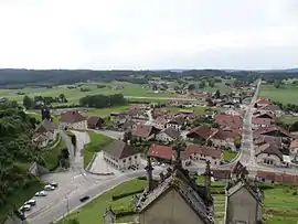 A general view of Sombacour | |
.svg.png.webp) Coat of arms | |
Location of Sombacour 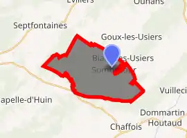
| |
 Sombacour  Sombacour | |
| Coordinates: 46°57′15″N 6°15′28″E | |
| Country | France |
| Region | Bourgogne-Franche-Comté |
| Department | Doubs |
| Arrondissement | Pontarlier |
| Canton | Ornans |
| Intercommunality | Altitude 800 |
| Government | |
| • Mayor (2008–2014) | André Saillard |
| Area 1 | 19.3 km2 (7.5 sq mi) |
| Population (2017-01-01)[1] | 641 |
| • Density | 33/km2 (86/sq mi) |
| Time zone | UTC+01:00 (CET) |
| • Summer (DST) | UTC+02:00 (CEST) |
| INSEE/Postal code | 25549 /25520 |
| Elevation | 715–907 m (2,346–2,976 ft) |
| 1 French Land Register data, which excludes lakes, ponds, glaciers > 1 km2 (0.386 sq mi or 247 acres) and river estuaries. | |
Geography
Sombacour lies 12 km (7.5 mi) northeast of Levier.
Population
| Year | Pop. | ±% |
|---|---|---|
| 1962 | 448 | — |
| 1968 | 463 | +3.3% |
| 1975 | 464 | +0.2% |
| 1982 | 512 | +10.3% |
| 1990 | 514 | +0.4% |
| 1999 | 524 | +1.9% |
| 2008 | 583 | +11.3% |
| 2012 | 613 | +5.1% |
See also
References
- "Populations légales 2017". INSEE. Retrieved 6 January 2020.
External links
| Wikimedia Commons has media related to Sombacour. |
- Sombacour on the regional Web site (in French)
| Authority control |
|---|
This article is issued from Wikipedia. The text is licensed under Creative Commons - Attribution - Sharealike. Additional terms may apply for the media files.