Arrondissements of Paris
The city of Paris is divided into twenty arrondissements municipaux, administrative districts, more simply referred to as arrondissements (pronounced [aʁɔ̃dismɑ̃] (![]() listen)).[1] These are not to be confused with departmental arrondissements, which subdivide the 100 French départements. The word "arrondissement", when applied to Paris, refers almost always to the municipal arrondissements listed below.
listen)).[1] These are not to be confused with departmental arrondissements, which subdivide the 100 French départements. The word "arrondissement", when applied to Paris, refers almost always to the municipal arrondissements listed below.
Arrondissement of Paris | |
|---|---|
| Country | |
| Region | Île-de-France |
| Department | Paris |
| Cantons | 20 |
| Communes | 1 |
| Préfecture | Paris |
| Area ¹ | |
| • Total | 105 km2 (41 sq mi) |
| Population (2009) | |
| • Total | 2,234,105 |
| • Density | 21,000/km2 (55,000/sq mi) |
| ¹ French Land Registry data, which exclude lakes, ponds, and glaciers larger than 1 km², as well as the estuaries of rivers. | |
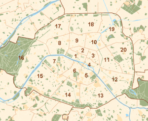 Arrondissements of Paris |
The number of the arrondissement is indicated by the last two digits in most Parisian postal codes (75001 up to 75020). In addition to their number, each arrondissement also has a name, often for a local monument. For example, the 5th arrondissement is also called "Panthéon" in reference to the building of the same name.
In early 2016, mayor Anne Hidalgo proposed that the first four arrondissements should have their administrations merged, and the Council of Paris approved this on 15 February. The four have a combined population of about 100,000, with the 1st, 2nd, 4th, and 3rd arrondissements in that order being the four smallest in Paris. The matter was taken up in the National Assembly in August 2016, and approved in February 2017. In a postal referendum from 8 to 14 October 2018, the town hall of the 3rd arrondissement was chosen to house the new shared administration, and the name "Paris Centre" was chosen for the sector. The reform was implemented on 29 June 2020, the day after the second round of the 2020 Paris municipal election, with the four arrondissements now sharing a mayor and a district council. The four arrondissements continue to exist, but are no longer used as administrative and electoral sectors.[2][3]
Description
The twenty arrondissements are arranged in the form of a clockwise spiral (often likened to a snail shell),[4] starting from the middle of the city, with the first on the Right Bank (north bank) of the Seine.
In French, notably on street signs, the number is often given in Roman numerals. For example, the Eiffel Tower belongs to the VIIe arrondissement while Gare de l'Est is in the Xe arrondissement. In daily speech, people use only the ordinal number corresponding to the arrondissement, e.g. "Elle habite dans le sixième", "She lives in the 6th (arrondissement)".
Arrondissements
| Arrondissement (R for Right Bank, L for Left Bank) |
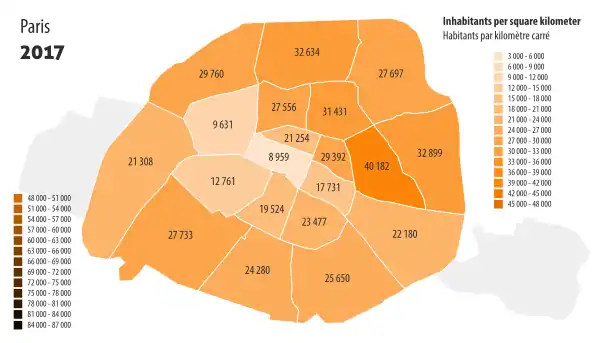
Name | Area (km2) | Population (2017 estimate) |
Density (2017) (inhabitants per km2) |
Peak of population | Mayor (2020-2026) |
|---|---|---|---|---|---|---|
| 1st(Ier) R Administratively part of Paris Centre | Louvre | 5.59 km2 (2.16 sq mi) | 100,196 | 17,924 | before 1861 |  Ariel Weil (PS) |
| 2nd (IIe) R Administratively part of Paris Centre | Bourse | before 1861 | ||||
| 3rd (IIIe) R Administratively part of Paris Centre | Temple | before 1861 | ||||
| 4th (IVe) R Administratively part of Paris Centre | Hôtel-de-Ville | before 1861 | ||||
| 5th (Ve) L | Panthéon | 2.541 km2 (0.981 sq mi) | 59,631 | 23,477 | 1911 | .jpg.webp) Florence Berthout (DVD) |
| 6th (VIe) L | Luxembourg | 2.154 km2 (0.832 sq mi) | 41,976 | 19,524 | 1911 |  Jean-Pierre Lecoq (LR) |
| 7th (VIIe) L | Palais-Bourbon | 4.088 km2 (1.578 sq mi) | 52,193 | 12,761 | 1926 | .jpg.webp) Rachida Dati (LR) |
| 8th (VIIIe) R | Élysée | 3.881 km2 (1.498 sq mi) | 37,368 | 9,631 | 1891 |  Jeanne d'Hauteserre (LR) |
| 9th (IXe) R | Opéra | 2.179 km2 (0.841 sq mi) | 60,071 | 27,556 | 1901 | Delphine Bürkli (DVD) |
| 10th (Xe) R | Entrepôt | 2.892 km2 (1.117 sq mi) | 90,836 | 31,431 | 1881 | Alexandra Cordebard (PS) |
| 11th (XIe) R | Popincourt | 3.666 km2 (1.415 sq mi) | 147,470 | 40,183 | 1911 |  François Vauglin (PS) |
| 12th (XIIe) R | Reuilly | 16.324 km2 (6.303 sq mi)¹ 6.377 km2 (2.462 sq mi)² | 141,287 | 8,657¹ 21,729² | 1962 | Emmanuelle Pierre-Marie (The Greens) |
| 13th (XIIIe) L | Gobelins | 7.146 km2 (2.759 sq mi) | 183,399 | 25,650 | 20055 |  Jérôme Coumet (PS) |
| 14th (XIVe) L | Observatoire | 5.621 km2 (2.170 sq mi) | 136,941 | 24,280 | 1954 |  Carine Petit (Gt.s) |
| 15th (XVe) L | Vaugirard | 8.502 km2 (3.283 sq mi) | 235,178 | 27,733 | 1962 |  Philippe Goujon (LR) |
| 16th (XVIe) R | Passy | 16.305 km2 (6.295 sq mi)³ 7.846 km2 (3.029 sq mi)4 | 149,500 | 9,169³ 19,0544 | 1962 | .jpg.webp) Francis Szpiner (LR) |
| 17th (XVIIe) R | Batignolles-Monceau | 5.669 km2 (2.189 sq mi) | 168,737 | 29,760 | 1954 | Geoffroy Boulard (LR) |
| 18th (XVIIIe) R | Butte-Montmartre | 6.005 km2 (2.319 sq mi) | 196,131 | 32,634 | 1931 |  Éric Lejoindre (PS) |
| 19th (XIXe) R | Buttes-Chaumont | 6.786 km2 (2.620 sq mi) | 188,066 | 27,697 | 20055 |  François Dagnaud (PS) |
| 20th (XXe) R | Ménilmontant | 5.984 km2 (2.310 sq mi) | 191,800 | 32,052 | 1936 | Éric Pliez (DVG) |
Notes:
1. With the Bois de Vincennes
2. Without the Bois de Vincennes
3. With the Bois de Boulogne
4. Without the Bois de Boulogne
5. 2005 is the year of the most recent official estimate; population of these arrondissements may still be growing
Each arrondissement is subdivided administratively into four quartiers. Paris thus has 80 quartiers administratifs, each containing a police station. For a table giving the names of the eighty quartiers, see Quarters of Paris.
History

On 11 October 1795, Paris was divided into twelve arrondissements. They were numbered from west to east, with the numbers 1–9 situated on the Right Bank of the Seine and the numbers 10–12 on the Left Bank. Each arrondissement was subdivided into four quartiers, which corresponded to the 48 original districts created in 1790.
Emperor Napoleon III and the Prefect of the Seine Baron Haussmann developed a plan to incorporate several of the surrounding communes into the Paris jurisdiction in the late 1850s. Parliament passed the necessary legislation in 1859, and the expansion took effect when the law was promulgated on 3 November 1859 (though city taxes were not extended to the new neighborhoods until 1 July 1860).[5] The previous twelve arrondissements were reorganized from twelve arrondissements into twenty. When Haussmann released his plan for the new boundaries and numbering system, residents of Passy objected because it placed them in the new thirteenth arrondissement, and at the time the expression "they were married in the thirteenth" was "a jocular way of referring to non-marital cohabitation". The mayor of Passy, Jean-Frédéric Possoz, devised the idea of a numbering the arrondissements in a spiral pattern beginning with the first centered on the imperial palaces, which put Passy in the sixteenth.[6]
In historical records, when it is important to distinguish between two systems, the original arrondissements are indicated by adding the term ancienne ("former" or "old"), for example, 2ème ancienne or 7ème anc.
Both a city and a département (French national administrative subdivision), Paris has since 1982 and the PLM law (Paris-Lyon-Marseille law) both a city council and 20 arrondissement councils. The PLM law also set limits to the prerogatives of the mayor of Paris, who has to deal with the powers granted to the prefect of police on security issues. The 20 arrondissement councils (conseils d'arrondissement) are similar in operation to the municipal council (conseil municipal) but with very few powers.[7] Its members are elected at municipal elections in the same way as in municipalities with more than 3,500 inhabitants. The arrondissement council is made up of 2/3 arrondissement councilors and 1/3 of city councilors, elected in the arrondissement but who also sit on the Paris city council. At its first meeting after the elections, each arrondissement council elects its mayor.[7]
Pictures
- 1st arrondissement of Paris, 2nd arrondissement of Paris, 3rd arrondissement of Paris, 4th arrondissement of Paris : Paris - Centre


_01.jpg.webp)
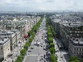
- 5th arrondissement of Paris, 6th arrondissement of Paris, 7th arrondissement of Paris : Paris - Left Bank


.jpg.webp)


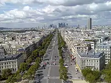
- 8th arrondissement of Paris, 9th arrondissement of Paris, 10th arrondissement of Paris, 11th arrondissement of Paris : Paris - Right Bank


.jpg.webp)


%252C_r%C3%A9am%C3%A9nagement%252C_2013-06-14_18.jpg.webp)

- 12th arrondissement of Paris, 13th arrondissement of Paris : Paris - East
.jpg.webp)


.jpg.webp)


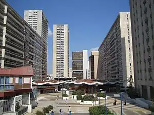
.jpg.webp)
- 14th arrondissement of Paris, 15th arrondissement of Paris : Paris - South


.jpg.webp)


- 16th arrondissement of Paris, 17th arrondissement of Paris : Paris - West

.jpg.webp)


- 18th arrondissement of Paris, 19th arrondissement of Paris, 20th arrondissement of Paris : Paris - North

.jpg.webp)

.jpg.webp)


See also
- Arrondissement, for other uses of the term.
- Historical quarters of Paris
- Paris, je t'aime, film composed of five-minute sequences on each arrondissement
- Administration of Paris
References
- "Diagrams of each arrondissement showing its quartiers administratifs". Paris.fr (in French). 11 April 2005. Archived from the original on 7 December 2008. Retrieved 24 May 2019.
- Paris Council Plans to Combine Arrondissements from frenchly.us
- Paris redraws map as four arrondissements unite under new name from The Local France
- Pientka, Cheryl A.; Alexiou, Joseph (26 March 2007). Paris For Dummies. John Wiley & Sons. ISBN 9780470085844.
- Carmona 2002, p. 313–5.
- Carmona 2002, p. 321–2.
- "Map of Paris arrondissements". Paris Digest. 2018. Retrieved 28 August 2018.
Bibliography
- Carmona, Michel (2002). Haussmann: His Life and Times and the Making of Modern Paris. Chicago: Ivan R. Dee. p. 516. ISBN 9781566634274.CS1 maint: ref=harv (link)
External links
- Official Paris website
- Website showing location, numbering conventions, and general info for arrondissements