Arthur's Pass National Park
Arthur's Pass National Park is located in the South Island of New Zealand and covers 1,185 km² of mostly mountainous terrain.[1]
| Arthur's Pass National Park | |
|---|---|
IUCN category II (national park) | |
 Map of New Zealand | |
| Location | Canterbury, New Zealand |
| Nearest city | Christchurch, New Zealand |
| Coordinates | 42°57′S 171°34′E |
| Area | 1,184.7 km2 (457.4 sq mi) |
| Established | 1929 |
| Governing body | Department of Conservation |
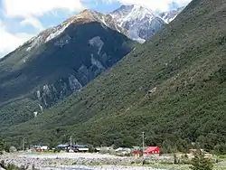


It was established in 1929, becoming the first national park in the South Island and the third in New Zealand. It is bisected by State Highway 73. The road passes through Arthur's Pass village and the mountain pass with the same name over the Southern Alps at a height of 920 metres above sea level. The park is administered by the Department of Conservation and operate a depot, administration and information centre in Arthur's Pass village.
Geography
The park is very distinctly split by the main divide of the South Island. The eastern side is typically drier and consists of beech forest and wide riverbeds, while the western side contains dense rainforest. Much of the geography was formed by ancient glacial action, forming flat bottomed U-shaped valleys. In the middle is a high range, consisting of large, snow-covered peaks and scree slopes.[2]
The park contains the following geographical features:
- A portion of the main divide of the South Island, including the following passes - Harman, Waimakariri Col, Arthur's itself, Goat (on the Mingha-Deception route), Tarahuna, Worsley, Minchin and Harper.
- The source of the Waimakariri River, very close the Waimakariri Falls Hut.
- Numerous tributaries to the Waimakariri River, including the Bealey, Poulter, Hawdon, White, Crow and Anti Crow Rivers.
- Numerous tributaries to the Taramakau River, including the Otira, Deception and Otehake Rivers.
- Mt Murchison at 2400 m is the highest peak within the park.[2]
Recreation
The park is popular for tramping, skiing, hunting and mountaineering.
- Mingha-Deception, part of the Coast to Coast race
Avalanche Peak
Avalanche Peak is the only peak in Arthur's Pass National Park that is marked by a poled route to the summit. The climb is a steep but enjoyable 1100 meters vertical from the Arthur's Pass village. On a clear day, you will be rewarded with epic views of the southern alps.[3]
Mount Rolleston
Mount Rolleston is one of the highest peaks in the National Park. it is 2271 meters tall. It is a popular mountain to climb and there are multiple ways to climb it[4] The Rolleston Glacier has melted significantly and the degree of the melt in 2011 would be a 1-in-100-year event under natural conditions, but due to climate change this has become a 1-in-8-year event.[5]
Bealey Spur Track
This is one of the most popular day trips in Arthur's Pass National Park. It is an easy 2.5 hour walk up to the Bealey Spur Hut. The views over the Wamaikariri Basin and surrounding mountains on a fine day are worth the climb. [6]
Edwards-Hawdon Tramping Track
This spectacular tramping trip travels up the Edwards River, crosses two alpine Passes and then travels down the Hawdon River. The Department of Conservation website describes it as "...best of Arthur's Pass National Park's stunning alpine landscapes. The picturesque hanging valley at Walker Pass is a fitting reward and worth every step over Taruahuna Pass and the steep climb up to Tarn Col". [7] This is typically a two night /three day tramp with stops at Edwards Hut (16 bunks) and Hawdon Hut (20 Huts). It is suitable for very experienced tramping groups only.
Cass-Lagoon Tramping Track
This tramp crosses the Cass saddle before descending to the comfortable 20 bunk Hamilton Hut. On the second day, the route crossed the Lagoon saddle. [8] it is a very popular weekend trip as it is easily accessible from Christchurch. It is suitable for experienced trampers only. it is roughly 34 kilometers long and climbs and descends a total of 2100 meters.
Park safety
Arthur's Pass National Park has a reputation as one of the most dangerous national parks in New Zealand.[9] In the first three months of 2006 alone two people died whilst walking in the park. Whilst no formal studies have been conducted, amongst the tramping community and the permanent Arthur's Pass community it is felt that the combination of harsh alpine terrain and easy accessibility combine to contribute to the high death and injury rate.
The mountains around Arthur's Pass contain some very challenging terrain. The marked day walks in the park, all easily accessible from the Arthur's Pass village carparks, involve vertical ascents of around 1000 metres (3000 feet) and include several hours well above the tree line. The peaks are highly exposed to the weather, the tracks are often very steep (steep enough to require the walker to pull themselves up with their hands in some places) and are often marked only by poles strung across a rocky landscape. Below the tree line the bush is dense and thick. In common with many alpine areas the weather is subject to frequent and sudden change. There are frequent bluffs and cliffs and most creeks running down the mountains tumble over waterfalls in one place or another. Further, there are a number of harder routes within the park that require a high level of mountaineering skill and the use of ropes and other such equipment. In short, safely traversing the terrain requires at least a moderate level of experience, knowledge and equipment as it is true 'back country'.
Arthur's Pass National Park is also within a few hours' driving time of Christchurch, the largest city in the South Island of New Zealand. This easy access for visitors to New Zealand, as well as the immediate access to the mountain trails from the village (unlike many other parts of the Alps where getting to the mountains requires a day or more tramp over more gentle terrain, which tends to dissuade the less prepared tramper) appears to lead to larger numbers of unprepared persons overstepping their abilities and getting into mortal peril. The most common scenarios are: persons caught above the tree line in bad weather with insufficient clothing and/or food then suffer from hypothermia; persons attempt a climb that requires knowledge or equipment they do not possess and often become stuck on a ledge or cliff, unable to climb back or continue on due to the steepness of the terrain, often then facing the problems of bad weather/hypothermia; persons attempt a climb that requires knowledge or equipment they do not possess and attempt a manoeuvre that result in a serious or fatal fall; persons become lost or disoriented, often due to change of weather, lose the trail or attempt to take a shortcut and suffer a serious or fatal fall.
See also
References
- "Data Table - Protected Areas - LINZ Data Service". Land Information New Zealand. Retrieved 18 October 2017.
- Arthur's Pass National Park > New Zealand, www.newzealand.com. Retrieved 30 November 2009
- "Avalanche Peak route". Department of Conservation.
- "Mt Rolleston | ClimbNZ | climbnz.org.nz". climbnz.org.nz. Retrieved 15 September 2020.
- "NZ glacier melt linked to climate change". Cosmos Magazine. 3 August 2020. Retrieved 15 September 2020.
- "Bealey Spur Track". www.doc.govt.nz. Retrieved 15 September 2020.
- "Edwards-Hawdon Route".
- "Cass-Lagoon Saddle Track". www.doc.govt.nz. Retrieved 15 September 2020.
- "Arthurs Pass National Park travel info: most dangerous - beautiful park". Travellerhints.com - Best Nightlife Party Fun Info. Retrieved 5 November 2018.
External links
| Wikimedia Commons has media related to Arthur's Pass National Park. |
| Wikivoyage has a travel guide for Arthur's Pass National Park. |
- Department of Conservation information on Arthur's Pass National Park
- Arthur's Pass Information - useful website maintained by a knowledgeable local
| Authority control |
|---|