Atkinson, Nebraska
Atkinson is a city in Holt County, Nebraska, United States. The population was 1,245 at the 2010 census.
Atkinson, Nebraska | |
|---|---|
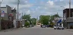 Downtown Atkinson: State Street | |
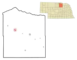 Location of Atkinson, Nebraska | |
| Coordinates: 42°31′54″N 98°58′37″W | |
| Country | United States |
| State | Nebraska |
| County | Holt |
| Area | |
| • Total | 1.64 sq mi (4.24 km2) |
| • Land | 1.64 sq mi (4.24 km2) |
| • Water | 0.00 sq mi (0.00 km2) |
| Elevation | 2,106 ft (642 m) |
| Population | |
| • Total | 1,245 |
| • Estimate (2019)[3] | 1,229 |
| • Density | 751.22/sq mi (290.04/km2) |
| Time zone | UTC-6 (Central (CST)) |
| • Summer (DST) | UTC-5 (CDT) |
| ZIP code | 68713 |
| Area code(s) | 402 |
| FIPS code | 31-02550[4] |
| GNIS feature ID | 0827106[5] |
| Website | http://www.atkinsonne.com/ |
History
The first settlement at Atkinson was made circa 1875.[6] Atkinson was platted in 1880, when the railroad was extended to that point.[7] It was named for Col. John Atkinson, an original owner of the town site.[8][9]
Geography
Atkinson is located at 42°31′54″N 98°58′37″W (42.531681, -98.976835).[10]
According to the United States Census Bureau, the city has a total area of 1.63 square miles (4.22 km2), all land.[11]
Demographics
| Historical population | |||
|---|---|---|---|
| Census | Pop. | %± | |
| 1890 | 701 | — | |
| 1900 | 595 | −15.1% | |
| 1910 | 810 | 36.1% | |
| 1920 | 1,300 | 60.5% | |
| 1930 | 1,144 | −12.0% | |
| 1940 | 1,350 | 18.0% | |
| 1950 | 1,372 | 1.6% | |
| 1960 | 1,324 | −3.5% | |
| 1970 | 1,406 | 6.2% | |
| 1980 | 1,521 | 8.2% | |
| 1990 | 1,380 | −9.3% | |
| 2000 | 1,244 | −9.9% | |
| 2010 | 1,245 | 0.1% | |
| 2019 (est.) | 1,229 | [3] | −1.3% |
| U.S. Decennial Census[12] | |||
2010 census
As of the census[2] of 2010, there were 1,245 people, 549 households, and 322 families living in the city. The population density was 763.8 inhabitants per square mile (294.9/km2). There were 638 housing units at an average density of 391.4 per square mile (151.1/km2). The racial makeup of the city was 98.8% White, 0.2% African American, 0.6% Native American, 0.1% Pacific Islander, 0.2% from other races, and 0.2% from two or more races. Hispanic or Latino of any race were 0.5% of the population.
There were 549 households, of which 25.5% had children under the age of 18 living with them, 49.7% were married couples living together, 6.4% had a female householder with no husband present, 2.6% had a male householder with no wife present, and 41.3% were non-families. 38.6% of all households were made up of individuals, and 22.4% had someone living alone who was 65 years of age or older. The average household size was 2.19 and the average family size was 2.92.
The median age in the city was 46.1 years. 23.2% of residents were under the age of 18; 4.7% were between the ages of 18 and 24; 20.7% were from 25 to 44; 26.8% were from 45 to 64; and 24.3% were 65 years of age or older. The gender makeup of the city was 46.6% male and 53.4% female.
2000 census
As of the census[4] of 2000, there were 1,244 people, 537 households, and 322 families living in the city. The population density was 932.8 people per square mile (361.1/km2). There were 640 housing units at an average density of 479.9 per square mile (185.8/km2). The racial makeup of the city was 98.95% White, 0.08% African American, 0.08% Native American, 0.32% Asian, and 0.56% from two or more races. Hispanic or Latino of any race were 0.88% of the population.
There were 537 households, out of which 26.1% had children under the age of 18 living with them, 52.0% were married couples living together, 5.4% had a female householder with no husband present, and 40.0% were non-families. 36.7% of all households were made up of individuals, and 20.1% had someone living alone who was 65 years of age or older. The average household size was 2.20 and the average family size was 2.91.
In the city, the population was spread out, with 22.7% under the age of 18, 5.6% from 18 to 24, 23.4% from 25 to 44, 22.7% from 45 to 64, and 25.5% who were 65 years of age or older. The median age was 44 years. For every 100 females, there were 85.1 males. For every 100 females age 18 and over, there were 84.1 males.
As of 2000 the median income for a household in the city was $28,490, and the median income for a family was $36,094. Males had a median income of $22,500 versus $17,656 for females. The per capita income for the city was $17,085. About 10.0% of families and 14.6% of the population were below the poverty line, including 21.5% of those under age 18 and 11.9% of those age 65 or over.
Arts and culture
Hay Days is the town's main celebration, a 3-4 day celebration that takes place every August. Started in the early 1900's to celebrate the end of hay harvest season, the event now includes dances, a parade, games in the park, duck races, and more.[13]
Education
Atkinson has one high school, West Holt High School.[14]
Notable people
- Jim Hendricks, folk musician
- Rodney L. Johnson, brigadier general in the United States Army
- Bob Pease, Former Director of Urban Redevelopment Authority Of Pittsburgh[15]
- Meagan Winings, Miss Nebraska Teen USA 2004 and Miss Nebraska USA 2009
- Jack Hoffman, cancer patient and fundraiser
References
- "2019 U.S. Gazetteer Files". United States Census Bureau. Retrieved July 26, 2020.
- "U.S. Census website". United States Census Bureau. Retrieved 2012-06-24.
- "Population and Housing Unit Estimates". United States Census Bureau. May 24, 2020. Retrieved May 27, 2020.
- "U.S. Census website". United States Census Bureau. Retrieved 2008-01-31.
- "US Board on Geographic Names". United States Geological Survey. 2007-10-25. Retrieved 2008-01-31.
- Burr, George L. (1921). History of Hamilton and Clay Counties, Nebraska, Volume 1. S.J. Clarke Publishing Company. p. 119.
- "Atkinson, Holt County". Center for Advanced Land Management Information Technologies. University of Nebraska. Retrieved 13 August 2014.
- "Profile for Atkinson, NE". ePodunk. Retrieved 13 August 2014.
- Fitzpatrick, Lillian L. (1960). Nebraska Place-Names. University of Nebraska Press. ISBN 0-8032-5060-6. A 1925 edition is available for download at University of Nebraska—Lincoln Digital Commons.
- "US Gazetteer files: 2010, 2000, and 1990". United States Census Bureau. 2011-02-12. Retrieved 2011-04-23.
- "US Gazetteer files 2010". United States Census Bureau. Archived from the original on 2012-01-25. Retrieved 2012-06-24.
- "Census of Population and Housing". Census.gov. Retrieved June 4, 2015.
- "Atkinson Hay Days Celebration". VisitNebraska.com. Retrieved 2020-08-11.
- "Education". cityofatkinson. Retrieved 2020-08-11.
- "The story of urban renewal ", Pittsburgh Post-Gazette, May 21, 2000. Retrieved 2010-03-03
Municipalities and communities of Holt County, Nebraska, United States | ||
|---|---|---|
| Cities | Map of Nebraska highlighting Holt County | |
| Villages | ||
| Townships |
| |
| Unincorporated communities | ||
| ||
| Authority control |
|---|
