Holt County, Nebraska
Holt County is a county in the U.S. state of Nebraska. As of the 2010 United States Census, the population was 10,435.[1] Its county seat is O'Neill.[2]
Holt County | |
|---|---|
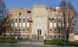 Holt County Courthouse in O'Neill | |
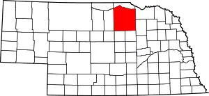 Location within the U.S. state of Nebraska | |
 Nebraska's location within the U.S. | |
| Coordinates: 42°28′N 98°47′W | |
| Country | |
| State | |
| Founded | 1862 (created 1876 (organized) |
| Named for | Joseph Holt |
| Seat | O'Neill |
| Largest city | O'Neill |
| Area | |
| • Total | 2,417 sq mi (6,260 km2) |
| • Land | 2,412 sq mi (6,250 km2) |
| • Water | 5.1 sq mi (13 km2) 0.2%% |
| Population | |
| • Estimate (2018) | 10,178 |
| • Density | 4.2/sq mi (1.6/km2) |
| Time zone | UTC−6 (Central) |
| • Summer (DST) | UTC−5 (CDT) |
| Congressional district | 3rd |
| Website | www |
Holt County is in the Outback area of Nebraska.[3]
In the Nebraska license plate system, Holt County is represented by the prefix 36 (it had the 36th-largest number of vehicles registered in the county when the license plate system was established in 1922).
History
Holt County was created by an act of the Nebraska Territory Legislature in 1862 and was organized in 1876.[4][5][6] It is named for Joseph Holt of Kentucky, who was Postmaster General and Secretary of War under President James Buchanan. It shares its name with Holt County, Missouri, though it is named for a different Holt.
Geography
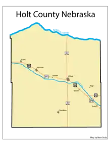
The terrain of Holt County consists of low rolling hills, with the flattened areas used for agriculture. The Niobrara River flows eastward along the north line of the county, and the Elkhorn River flows southeastward through the upper central portion of the county. The county has an area of 2,417 square miles (6,260 km2), of which 2,412 square miles (6,250 km2) is land and 5.1 square miles (13 km2) (0.2%) is water.[7] It is Nebraska's fifth-largest county by area.
Major highways
 U.S. Highway 20
 U.S. Highway 275
 U.S. Highway 281
 Nebraska Highway 11
 Nebraska Highway 95
Adjacent counties
- Boyd County - north
- Knox County - east
- Wheeler County - south
- Garfield County - south
- Loup County - southwest
- Rock County - west
- Keya Paha County - northwest
Demographics
| Historical population | |||
|---|---|---|---|
| Census | Pop. | %± | |
| 1880 | 3,287 | — | |
| 1890 | 13,672 | 315.9% | |
| 1900 | 12,224 | −10.6% | |
| 1910 | 15,545 | 27.2% | |
| 1920 | 17,151 | 10.3% | |
| 1930 | 16,509 | −3.7% | |
| 1940 | 16,552 | 0.3% | |
| 1950 | 14,489 | −12.5% | |
| 1960 | 13,722 | −5.3% | |
| 1970 | 12,933 | −5.7% | |
| 1980 | 13,552 | 4.8% | |
| 1990 | 12,599 | −7.0% | |
| 2000 | 11,551 | −8.3% | |
| 2010 | 10,435 | −9.7% | |
| 2018 (est.) | 10,178 | [8] | −2.5% |
| US Decennial Census[9] 1790-1960[10] 1900-1990[11] 1990-2000[12] 2010-2013[1] | |||
As of the 2000 United States Census,[13] there were 11,551 people, 4,608 households, and 3,170 families residing in the county. The population density was 5 people per square mile (2/km2). There were 5,281 housing units at an average density of 2 per square mile (1/km2). The racial makeup of the county was 98.86% White, 0.03% Black or African American, 0.29% Native American, 0.18% Asian, 0.05% Pacific Islander, 0.23% from other races, and 0.35% from two or more races. 0.71% of the population were Hispanic or Latino of any race. 46.0% were of German, 12.5% Irish, 8.6% American, 7.5% English and 5.4% Czech ancestry.
There were 4,608 households, out of which 31.60% had children under the age of 18 living with them, 60.70% were married couples living together, 5.60% had a female householder with no husband present, and 31.20% were non-families. 28.70% of all households were made up of individuals, and 15.10% had someone living alone who was 65 years of age or older. The average household size was 2.46 and the average family size was 3.06.
The county population contained 27.30% under the age of 18, 5.70% from 18 to 24, 24.50% from 25 to 44, 22.70% from 45 to 64, and 19.80% who were 65 years of age or older. The median age was 40 years. For every 100 females there were 96.90 males. For every 100 females age 18 and over, there were 93.50 males.
The median income for a household in the county was $30,738, and the median income for a family was $37,463. Males had a median income of $24,681 versus $17,593 for females. The per capita income for the county was $15,256. About 9.80% of families and 13.00% of the population were below the poverty line, including 15.00% of those under age 18 and 12.10% of those age 65 or over.
Communities
Unincorporated communities
Townships
- Antelope
- Atkinson
- Belle
- Chambers
- Cleveland
- Coleman
- Conley
- Deloit
- Dustin
- Emmet
- Ewing
- Fairview
- Francis
- Golden
- Grattan
- Green Valley
- Holt Creek
- Inman
- Iowa
- Josie
- Lake
- McClure
- Paddock
- Pleasant View
- Rock Falls
- Sand Creek
- Saratoga
- Scott
- Shamrock
- Sheridan
- Shields
- Steel Creek
- Stuart
- Swan
- Verdigris
- Willowdale
- Wyoming
Politics
Holt County voters have historically tended to vote Republican. In only two elections since 1916 has the county selected the Democratic Party candidate.
| Year | Republican | Democratic | Third Parties |
|---|---|---|---|
| 2016 | 85.1% 4,354 | 10.4% 531 | 4.6% 233 |
| 2012 | 79.4% 3,922 | 17.9% 882 | 2.7% 135 |
| 2008 | 75.3% 3,746 | 21.9% 1,089 | 2.8% 139 |
| 2004 | 81.5% 4,217 | 17.3% 894 | 1.2% 63 |
| 2000 | 79.7% 3,954 | 17.1% 846 | 3.2% 159 |
| 1996 | 65.3% 3,436 | 21.0% 1,107 | 13.7% 721 |
| 1992 | 54.9% 3,131 | 14.6% 835 | 30.5% 1,737 |
| 1988 | 74.7% 4,081 | 24.3% 1,327 | 1.1% 58 |
| 1984 | 83.2% 4,613 | 16.1% 893 | 0.7% 39 |
| 1980 | 77.0% 4,495 | 17.4% 1,016 | 5.6% 327 |
| 1976 | 64.2% 3,389 | 33.2% 1,751 | 2.6% 138 |
| 1972 | 79.8% 4,147 | 20.3% 1,053 | |
| 1968 | 66.0% 3,319 | 25.4% 1,278 | 8.6% 430 |
| 1964 | 53.8% 3,194 | 46.2% 2,739 | |
| 1960 | 63.0% 4,150 | 37.0% 2,438 | |
| 1956 | 69.3% 4,237 | 30.7% 1,874 | |
| 1952 | 74.7% 5,088 | 25.3% 1,726 | |
| 1948 | 54.6% 3,147 | 45.5% 2,622 | |
| 1944 | 62.1% 4,198 | 37.9% 2,565 | |
| 1940 | 61.6% 4,840 | 38.4% 3,016 | |
| 1936 | 47.8% 3,714 | 50.3% 3,902 | 1.9% 148 |
| 1932 | 33.0% 2,375 | 66.1% 4,761 | 0.9% 64 |
| 1928 | 54.4% 3,746 | 45.4% 3,126 | 0.2% 10 |
| 1924 | 37.1% 2,207 | 25.7% 1,529 | 37.1% 2,207 |
| 1920 | 64.6% 3,163 | 32.2% 1,577 | 3.2% 158 |
| 1916 | 40.2% 1,568 | 56.7% 2,213 | 3.1% 120 |
| 1912 | 21.6% 778 | 40.5% 1,456 | 37.9% 1,364 |
| 1908 | 44.3% 1,541 | 51.1% 1,777 | 4.7% 162 |
| 1904 | 52.9% 1,740 | 19.7% 646 | 27.4% 902 |
| 1900 | 45.1% 1,320 | 50.9% 1,492 | 4.0% 118 |
References
- "State & County QuickFacts". US Census Bureau. Archived from the original on June 7, 2011. Retrieved September 20, 2013.
- "Find a County". National Association of Counties. Archived from the original on 31 May 2011. Retrieved 7 June 2011.
- "About" Archived 2008-10-03 at the Wayback Machine, North Central RC&D.
- Fitzpatrick, Lilian Linder (1925). Nebraska Place-Names. Lincoln: University of Nebraska Studies in Language, Literature, and Criticism. p. 74. Retrieved December 15, 2014.
- Andreas, A. T. (1882). "Andreas' History of the State of Nebraska". The Kansas Collection. Archived from the original on 2003-11-13. Retrieved December 15, 2014.
- "Holt County". Nebraska Association of County Officials. Retrieved December 15, 2014.
- "2010 Census Gazetteer Files". United States Census Bureau. August 22, 2012. Archived from the original on November 13, 2013. Retrieved December 8, 2014.
- "Population and Housing Unit Estimates". Retrieved December 26, 2019.
- "US Decennial Census". US Census Bureau. Retrieved December 8, 2014.
- "Historical Census Browser". University of Virginia Library. Retrieved December 8, 2014.
- "Population of Counties by Decennial Census: 1900 to 1990". US Census Bureau. Retrieved December 8, 2014.
- "Census 2000 PHC-T-4. Ranking Tables for Counties: 1990 and 2000" (PDF). US Census Bureau. Retrieved December 8, 2014.
- "U.S. Census website". US Census Bureau. Retrieved 31 January 2008.
- Election Results
External links
Places adjacent to Holt County, Nebraska | ||||||||||
|---|---|---|---|---|---|---|---|---|---|---|
| ||||||||||
Municipalities and communities of Holt County, Nebraska, United States | ||
|---|---|---|
| Cities | Map of Nebraska highlighting Holt County | |
| Villages | ||
| Townships |
| |
| Unincorporated communities | ||
| ||

| Authority control |
|---|