Atlantic mixed forests
The Atlantic mixed forests is a terrestrial ecoregion in western Europe. It extends along the western edge of continental Europe, from southwestern France through northern France, Belgium, the Netherlands, northwestern Germany, and western Denmark. Most of the region's forests and dunes have been converted to fields, pastures, and forest plantations, and its once-extensive wetlands have mostly been drained and filled.[2]
| Atlantic mixed forests | |
|---|---|
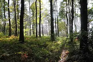 Forest Domaniale de Desvres, France | |
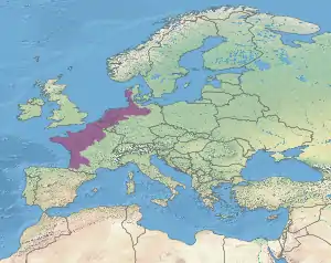 Location of the ecoregion (in purple) | |
| Ecology | |
| Realm | Palearctic |
| Biome | temperate broadleaf and mixed forests |
| Borders | List
|
| Geography | |
| Area | 380,246 km2 (146,814 sq mi) |
| Countries | |
| Conservation | |
| Conservation status | critical/endangered |
| Protected | 59,657 km² (16%)[1] |
Geography
The ecoregion covers and area of 380,246 km². The terrain is generally flat or gently rolling, except in Brittany where the terrain is hilly and the coast is rocky. In several places, notably the Landes forest in southwestern France, dunes extended inland for miles from the shore.[3]
Climate
The climate is temperate and maritime.
Flora
Mixed oak forests are typical, with Quercus robur and Betula pendula prevalent on acidic soils, and Q. robur and Fagus sylvatica on other soils. In the southern portion of the ecoregion Quercus petraea and Q. pubescens are also present. Pinus pinaster grows naturally on sandy soils, and has been planted extensively to stabilize dunes, along with Pinus sylvestris. Heathlands occur in coastal areas subject to wind and salt spray.[4]
Protected areas
59,657 km², or 16%, of the ecoregion is in protected areas. Another 19% of the ecoregion's area is forested but unprotected.[5]
In France, the system of regional nature parks preserves biodiversity and sustainable agriculture. Regional nature parks include farms and villages as well as forests, heathlands and wetlands. Regional nature parks in the Atlantic mixed forests include Armorique, Brenne, Boucles de la Seine normande, Caps et Marais d'Opale, Causses du Quercy, Gâtinais français, Haute Vallée de Chevreuse, Landes de Gascogne, Loire-Anjou-Touraine, Marais Du Cotentin Et Du Bessin, Marais poitevin, Montagne de Reims, Oise-Pays de France, Perche, Vallée de la Scarpe et de l'Escaut avesnois, and Vexin français.
Lüneburg Heath (Lüneburger Heide) in northern Germany includes area of heathland, bog, and downy oak forest, as well as coppiced woodlands and pine plantations.
Ecoregion delineation
The European Environment Agency's Digital Map of European Ecological Regions (DMEER) designates two Atlantic forest ecoregions – the Northern Temperate Atlantic and Southern Temperate Atlantic.[6] The WWF's system combines them into one Atlantic mixed forests ecoregion, with the same external boundary.
External links
| Wikimedia Commons has media related to European Atlantic mixed forests. |
- "Atlantic mixed forests". Terrestrial Ecoregions. World Wildlife Fund.
References
- Eric Dinerstein, David Olson, et al. (2017). An Ecoregion-Based Approach to Protecting Half the Terrestrial Realm, BioScience, Volume 67, Issue 6, June 2017, Pages 534–545; Supplemental material 2 table S1b.
- "Atlantic mixed forests". Terrestrial Ecoregions. World Wildlife Fund.
- "Atlantic mixed forests". Terrestrial Ecoregions. World Wildlife Fund.
- "Atlantic mixed forests". Terrestrial Ecoregions. World Wildlife Fund.
- Eric Dinerstein, David Olson, et al. (2017). An Ecoregion-Based Approach to Protecting Half the Terrestrial Realm, BioScience, Volume 67, Issue 6, June 2017, Pages 534–545; Supplemental material 2 table S1b.
- "DMEER: Digital Map of European Ecological Regions". European Environment Agency, 12 November 2009. Accessed 29 April 2020.