Nihonkai montane deciduous forests
The Nihonkai montane deciduous forests ecoregion (WWF ID:PA0428) covers the Nihonkai (Sea of Japan-side) mountain slopes of Japan's central island of Honshu, including most of the northern half of the island.[1][2] Also included in the ecoregion are the forested lowland hills of the Oshima Peninsula, which is the southern extension of Hokkaido Island.
| Ecoregion: Nihonkai montane deciduous forests | |
|---|---|
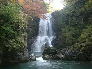 Naso no Shirataki (Naso Waterfall), Nikaho City,, Akita Prefecture | |
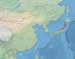 Ecoregion territory (in purple) | |
| Ecology | |
| Realm | Palearctic |
| Biome | Temperate broadleaf and mixed forests |
| Geography | |
| Area | 82,361 km2 (31,800 sq mi) |
| Country | Japan |
| Coordinates | 39.75°N 141.25°E |
Location and description
The ecoregion stretches for 800 kilometres (500 mi) up the western side of Honshu, from Wakasa Bay in the south and expanding to cover the breadth of the island by the time it reaches the northern coast. Elevations range from sea level to 2,959 metres (9,708 ft), with an average of 523 metres (1,716 ft).[3] Throughout the ecoregion, individual mountain peaks rise above the zone of deciduous trees into the Honshu alpine conifer forests ecoregion.
Climate
The climate of the ecoregion is Humid continental climate - Hot summer sub-type (Köppen climate classification Dfa), with large seasonal temperature differentials and a hot summer (at least one month averaging over 22 °C (72 °F), and mild winters.[4][5]
Flora and fauna
The climate is cooler in the north of Honshu than the south, with deciduous trees typified by Japanese beech (Fagus crenata) and Jolcham oak (Quercus serrata).
Protected areas
Protected areas in the ecoregion include:
References
- "Eastern Asia: Western Honshu Island, Japan". World Wildlife Federation. Retrieved March 21, 2020.
- "Map of Ecoregions 2017". Resolve, using WWF data. Retrieved September 14, 2019.
- "Nihonkai montane deciduous forests". Digital Observatory for Protected Areas. Retrieved July 17, 2020.
- Kottek, M., J. Grieser, C. Beck, B. Rudolf, and F. Rubel, 2006. "World Map of Koppen-Geiger Climate Classification Updated" (PDF). Gebrüder Borntraeger 2006. Retrieved September 14, 2019.CS1 maint: multiple names: authors list (link)
- "Dataset - Koppen climate classifications". World Bank. Retrieved September 14, 2019.