Atuncolla District
Atuncolla District is one of fifteen districts of Puno Province in Peru.[1]
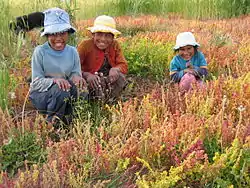
Canihua (Chenopodium pallidicaule) is one of the few crops that can be cultivated at the high elevations of Atuncolla district.
Atuncolla
Hatunqulla | |
|---|---|
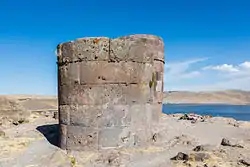 Sillustani and Lake Umayo | |
| Coordinates: 15°41′17″S 70°08′39″W | |
| Country | |
| Region | Puno |
| Province | Puno |
| Capital | Atuncolla |
| Government | |
| • Mayor | Nestor Quispe Ito |
| Area | |
| • Total | 124.74 km2 (48.16 sq mi) |
| Elevation | 3,822 m (12,539 ft) |
| Population | |
| • Total | 3,984 |
| • Density | 32/km2 (83/sq mi) |
| Time zone | UTC-5 (PET) |
| UBIGEO | 210104 |
Ethnic groups
The people in the district are mainly indigenous citizens of Quechua descent. Quechua is the first language which the majority of the population (90.06%) learnt to speak in childhood. 9.23% of the residents speak Spanish as a first language. (2007 Peru Census).[2]
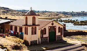
Church in Sillustani, Atuncolla district.
See also
References
- (in Spanish) Instituto Nacional de Estadística e Informática. Banco de Información Distrital Archived April 23, 2008, at the Wayback Machine. Retrieved April 11, 2008.
- inei.gob.pe Archived January 27, 2013, at the Wayback Machine INEI, Peru, Censos Nacionales 2007, Frequencias: Preguntas de Población: Idioma o lengua con el que aprendió hablar (in Spanish)
| |
|---|---|
| Azángaro | |
| Carabaya | |
| Chucuito | |
| El Collao | |
| Huancané | |
| Lampa | |
| Melgar | |
| Moho | |
| Puno | |
| San Antonio de Putina | |
| San Román | |
| Sandia | |
| Yunguyo | |
This article is issued from Wikipedia. The text is licensed under Creative Commons - Attribution - Sharealike. Additional terms may apply for the media files.
