Puno Province
Puno is a province in the Puno Region, in southeastern Peru. It borders the provinces of Huancane, San Román, El Collao and the Moquegua Region's province of General Sánchez Cerro. Its capital is the city of Puno, which is located at the edge of Lake Titicaca, the world's highest navigable lake. It is the economic powerhouse of the region.
Puno | |
|---|---|
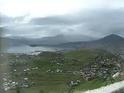 Puno, the capital of the region, and Lake Titicaca as seen from Puma Uta viewpoint | |
 Flag  Coat of arms | |
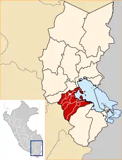 Location of Puno in the Puno Region | |
| Country | Peru |
| Region | Puno |
| Founded | March 16, 1956 |
| Capital | Puno |
| Government | |
| • Mayor | Martín Ticona Maquera (2019-2022) |
| Area | |
| • Total | 6,494.76 km2 (2,507.64 sq mi) |
| Elevation | 3,827 m (12,556 ft) |
| Population | |
| • Total | 219,494 |
| • Density | 34/km2 (88/sq mi) |
| UBIGEO | 2101 |
| Website | www |
Geography
Some of the highest mountains of the province are listed below:[1]
- Allpaqani
- Anta Qayqu
- Arichuwa
- Asiruni
- Challwani
- Chuqi Liwa
- Chuqipata
- Churi Wiqu
- Chuwallani
- Ch'iyar Jaqhi
- Ch'iyar Jaqhi (Puno)
- Inka Laya
- Jach'a Phaq'u Q'awa
- Jach'a Qullu
- Janq'u Jaqhi
- Janq'u Qalani
- Janq'u Saxa
- Janq'u Saywani
- Jat'u K'achi
- Jayu Jayuni
- Jichu Qullu
- Kuntur Ikiña
- Kuntur Ikiña (Pich.)
- Kunturini
- Kunturiri
- K'ara K'arani
- Laq'a Apachita
- Llallawa
- Millu
- Mulluq'u
- Muru Jaqhi
- Nasa Parqu
- Pinkilluni
- Puka Kancha Punta
- Puka Phuju
- Pukara
- Pumamarka
- Pura Purani
- Phaq'u Apachita
- Phaq'u Q'awa
- Qachi Qullu
- Qina Qinani
- Qutuni
- Q'ara Qullu
- Q'atawi
- Q'illu Chuta
- Q'isanani
- Q'iwiri
- Qurini
- Q'ulini
- Salla Qachi
- Sirka Sirka
- Supay Laya
- Surichata
- Tankani
- Tankani (Pich.)
- Taypi Qullu
- Uturunqani
- Wallata
- Wallqani
- Wankarani
- Warawarani
- Wayllani
- Wila Kunkani
- Wila Qullu
- Wila Salla
- Wila Wila
- Wilantay
- Wilaquta
- Wiluyu (Mañ.-Tiqui.)
- Wiluyu (Tiqui.)
- Yaritani
- Yuraq Punta
Political division
The province is divided into fifteen districts (Spanish: distritos, singular: distrito):
Ethnic groups
The province is inhabited by indigenous citizens of Aymara and Quechua descent. Spanish is the language which the majority of the population (45.40%) learnt to speak in childhood, 27.67% of the residents started speaking using the Quechua language and 26.50% using Aymara (2007 Peru Census).[2]
See also
Sources
- escale.minedu.gob.pe - UGEL map of the Puno Province 1 (Puno Region)
- inei.gob.pe Archived 2013-01-27 at the Wayback Machine INEI, Peru, Censos Nacionales 2007
| |
|---|---|