El Collao Province
El Collao Province is a province of the Puno Region in Peru,[1] created in 1992. The capital of the province is the city of Ilave.
El Collao | |
|---|---|
 Flag  Coat of arms | |
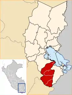 Location of El Collao in the Puno Region | |
| Country | Peru |
| Region | Puno |
| Founded | 1992 |
| Capital | Ilave |
| Area | |
| • Total | 5,600.51 km2 (2,162.37 sq mi) |
| Population | |
| • Total | 76,749 |
| • Density | 14/km2 (35/sq mi) |
| UBIGEO | 2105 |
Political division
The province measures 5,600.51 square kilometres (2,162.37 sq mi) and is divided into five districts:
| District | Mayor | Capital | Ubigeo |
|---|---|---|---|
| Capazo | Eulario Modesto Mayta Ccollo | Capazo | 210502 |
| Conduriri | Pedro Montalico Quenta | Conduriri | 210505 |
| Ilave | Fortunato Calli Incacutipa | Ilave | 210501 |
| Pilcuyo | Isidro Lupaca Ticona | Pilcuyo | 210503 |
| Santa Rosa | Ismael Acero Mamani | Mazo Cruz | 210504 |
Geography
Some of the highest peaks of the province are Panti Usu and Suri. Other mountains are listed below:[2]
|
|
|
Ethnic groups
The people in the province are mainly indigenous citizens of Aymara descent. Aymara is the language which the majority of the population (76.51%) learnt to speak in childhood, 22.57% of the residents started speaking using the Spanish language and 0.65% using Quechua (2007 Peru Census).[3]
See also
References
- (in Spanish) Instituto Nacional de Estadística e Informática. Banco de Información Digital Archived April 23, 2008, at the Wayback Machine, Retrieved December 29, 2007
- escale.minedu.gob.pe - UGEL map of the El Collao Province (Puno Region)
- inei.gob.pe Archived January 27, 2013, at the Wayback Machine INEI, Peru, Censos Nacionales 2007
| Wikimedia Commons has media related to El Collao Province. |
| |
|---|---|
This article is issued from Wikipedia. The text is licensed under Creative Commons - Attribution - Sharealike. Additional terms may apply for the media files.