B4 road (Namibia)
B4 is a national highway of Namibia. It passes through the ǁKaras Region of Namibia in the south-west in a west–east direction for 334 kilometres (208 mi), connecting Lüderitz on the coast to Keetmanshoop.
| ||||
|---|---|---|---|---|
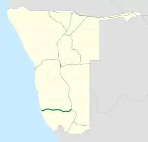 Map of the B4. | ||||
| Route information | ||||
| Maintained by Roads Authority Namibia | ||||
| Length | 334 km (208 mi) | |||
| Major junctions | ||||
| East end | ||||
| West end | Lüderitz | |||
| Location | ||||
| Major cities | Keetmanshoop, Aus, Lüderitz | |||
| Towns | Seeheim, Goageb, Garub, Kolmanskop | |||
| Highway system | ||||
Transport in Namibia
| ||||

B4 road
The B4 crosses the Sperrgebiet, an area restricted for diamond mining along the coast of the Atlantic, between Aus and Lüderitz. Travellers may leave the road only at demarcated places. It also forms the southern border of the Namib-Naukluft National Park.[1]
References
- Bridgeford, Peter (2008). "One Hundred Years of Conservation. From Game Reserve No.3 to Namib-Naukluft Park" (PDF). Journal. Namibia Scientific Society. 56 (56): 58.
| Freeways | ||
|---|---|---|
| Trunk routes | ||
| Secondary routes | ||
| International routes | ||
This article is issued from Wikipedia. The text is licensed under Creative Commons - Attribution - Sharealike. Additional terms may apply for the media files.