B6 road (Namibia)
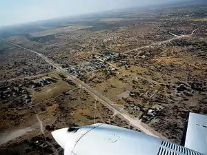
B6 is a national highway of eastern-central Namibia. It is 318 kilometres (198 mi) long and connects the capital Windhoek with the Buitepos border crossing to Botswana. Gobabis, the capital of Omaheke Region, lies on the B6, as do the villages of Seeis, Omitara and Witvlei. Hosea Kutako International Airport is also located on the B6, east of Windhoek.
| ||||
|---|---|---|---|---|
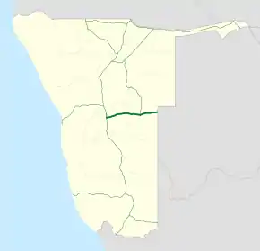 Map of the B6. | ||||
| Route information | ||||
| Maintained by Roads Authority Namibia | ||||
| Length | 318 km (198 mi) | |||
| Major junctions | ||||
| West end | ||||
| East end | A2 at the Botswanan border at Buitepos | |||
| Location | ||||
| Towns | Windhoek, Gobabis | |||
| Highway system | ||||
Transport in Namibia
| ||||

The entire length of the B6 is part of the Trans-Kalahari Corridor route that connects the Namibian harbour town of Walvis Bay via Botswana with Maputo, the capital of Mozambique.[1]
History
District roads between Windhoek and Witvlei and between Witvlei and Gobabis had been proclaimed in 1912 by the colonial administration of German South West Africa. As all other roads at that time these roads were ox wagon tracks cleared of boulders but otherwise unconstructed. The territory had a total of only 5 motor vehicles at that time, and transport by motor vehicle only increased significantly with the deployment of South African troops during World War I.[2]
References
Notes
- Tjitemisa, Kuzeeko (16 February 2017). "Trans-Kalahari railway line on track". Lela. Archived from the original on 22 June 2017.
- Dierks 2001, 3. The History of Namibian Roads in the German Era.
Literature
- Dierks, Klaus (2001). Namibian Roads in History from the 13th Century till Today. Institut für Wirtschafts- und Sozialgeographie, Johann Wolfgang Goethe-Universität Frankfurt/Main.
| Freeways | ||
|---|---|---|
| Trunk routes | ||
| Secondary routes | ||
| International routes | ||