Bad Kreuzen
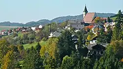
Bad Kreuzen is a municipality in the district Perg in the Austrian state of Upper Austria.
Bad Kreuzen | |
|---|---|
 Bad Kreuzen | |
 Coat of arms | |
 Bad Kreuzen Location within Austria | |
| Coordinates: 48°16′00″N 14°48′23″E | |
| Country | Austria |
| State | Upper Austria |
| District | Perg |
| Government | |
| • Mayor | Manfred Nenning (ÖVP) |
| Area | |
| • Total | 39.9 km2 (15.4 sq mi) |
| Elevation | 474 m (1,555 ft) |
| Population (2018-01-01)[2] | |
| • Total | 2,266 |
| • Density | 57/km2 (150/sq mi) |
| Time zone | UTC+1 (CET) |
| • Summer (DST) | UTC+2 (CEST) |
| Postal code | 4362 |
| Area code | 07266 |
| Vehicle registration | PE |
| Website | www.bad-kreuzen.at |
History The area around Kreuzen is said to have been cleared by Slavs between the 8th and 11th centuries, and the name Kreuzen is partly interpreted in Slavic terms. In 1147 Otto von Machland donated his clearing parish - Kreuzen - to the Augustinian canons of Waldhausen, which he founded.
Geography
Bad Kreuzen lies 7 km north of the Danube near Grein. About 29 percent of the municipality is forest, and 65 percent is farmland.
References
- "Dauersiedlungsraum der Gemeinden Politischen Bezirke und Bundesländer - Gebietsstand 1.1.2018". Statistics Austria. Retrieved 10 March 2019.
- "Einwohnerzahl 1.1.2018 nach Gemeinden mit Status, Gebietsstand 1.1.2018". Statistics Austria. Retrieved 9 March 2019.
| Wikimedia Commons has media related to Bad Kreuzen. |
| Authority control |
|---|
This article is issued from Wikipedia. The text is licensed under Creative Commons - Attribution - Sharealike. Additional terms may apply for the media files.
