Baumgartenberg
Baumgartenberg is a municipality in the district Perg in the Austrian state of Upper Austria.
Baumgartenberg | |
|---|---|
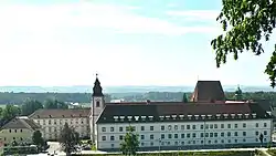 Monastery | |
 Coat of arms | |
 Baumgartenberg Location within Austria | |
| Coordinates: 48°12′32″N 14°44′39″E | |
| Country | Austria |
| State | Upper Austria |
| District | Perg |
| Government | |
| • Mayor | Erwin Kastner (ÖVP) |
| Area | |
| • Total | 15.73 km2 (6.07 sq mi) |
| Elevation | 237 m (778 ft) |
| Population (2018-01-01)[2] | |
| • Total | 1,734 |
| • Density | 110/km2 (290/sq mi) |
| Time zone | UTC+1 (CET) |
| • Summer (DST) | UTC+2 (CEST) |
| Postal code | 4342 |
| Area code | 07269 |
| Vehicle registration | PE |
| Website | www.baumgartenberg.at |
Geography
Baumgartenberg lies at 237 meters. The extension is 4.5 kilometers from north to south, from west to east 6.8 kilometers. The total area is 15.7 kilometers ². 23.6% of the area is forested, 63.7% of the area ais used for agriculture.
Quarters include Amesbach, Au, Baumgartenberg, Deiming, Hehenberger, High, Kolbinger, Kühofen, Fiefs, Mettensdorf, Muhlberg, Obergassolding, Pitzing, Schneckenreit, Steindl and Untergassolding.
Population
| Year | Pop. | ±% |
|---|---|---|
| 1869 | 1,227 | — |
| 1880 | 1,336 | +8.9% |
| 1890 | 1,391 | +4.1% |
| 1900 | 1,519 | +9.2% |
| 1910 | 1,399 | −7.9% |
| 1923 | 1,385 | −1.0% |
| 1934 | 1,429 | +3.2% |
| 1939 | 1,364 | −4.5% |
| 1951 | 1,165 | −14.6% |
| 1961 | 1,121 | −3.8% |
| 1971 | 1,295 | +15.5% |
| 1981 | 1,402 | +8.3% |
| 1991 | 1,442 | +2.9% |
| 2001 | 1,399 | −3.0% |
| 2009 | 1,548 | +10.7% |
| 2015 | 1,696 | +9.6% |
References
- "Dauersiedlungsraum der Gemeinden Politischen Bezirke und Bundesländer - Gebietsstand 1.1.2018". Statistics Austria. Retrieved 10 March 2019.
- "Einwohnerzahl 1.1.2018 nach Gemeinden mit Status, Gebietsstand 1.1.2018". Statistics Austria. Retrieved 9 March 2019.
| Wikimedia Commons has media related to Baumgartenberg. |
This article is issued from Wikipedia. The text is licensed under Creative Commons - Attribution - Sharealike. Additional terms may apply for the media files.
