Bad Saarow
Bad Saarow (Lower Sorbian: Zarow) is a municipality in the Oder-Spree district, in Brandenburg, Germany.
Bad Saarow | |
|---|---|
 Bad Saarow railway station | |
Location of Bad Saarow within Oder-Spree district  | |
 Bad Saarow  Bad Saarow | |
| Coordinates: 52°16′59″N 14°04′00″E | |
| Country | Germany |
| State | Brandenburg |
| District | Oder-Spree |
| Municipal assoc. | Scharmützelsee |
| Subdivisions | 4 Ortsteile |
| Government | |
| • Mayor | Susanne Rolle (CDU) |
| Area | |
| • Total | 51.98 km2 (20.07 sq mi) |
| Elevation | 45 m (148 ft) |
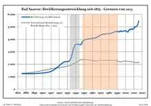
| Population (2019-12-31)[1] | |
| • Total | 6,003 |
| • Density | 120/km2 (300/sq mi) |
| Time zone | UTC+01:00 (CET) |
| • Summer (DST) | UTC+02:00 (CEST) |
| Postal codes | 15526 |
| Dialling codes | 033631 |
| Vehicle registration | LOS |
| Website | www.bad-saarow.de |
The place is known for its hot springs and for its mineral-rich mud. Their healing properties have attracted visitors for many years, and in 1923 led to the town's name acquiring the prefix Bad ("bath", "spa").
Nearby are the Dubrower Berge, a range of wooded hills popular with hikers and cyclists.
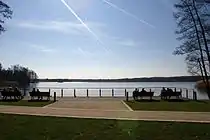
Bad Saarow Scharmützelsee (Scharmützel lake)
Demography
|
|
Sons and daughters of the town
- Jörg Schönbohm (born 1937 in Neu Golm), former Lieutenant general of the Bundeswehr, 1999-2009 Minister of the Interior of the State of Brandenburg
- Cornelia Ernst (born 1956), politician (The Left)
- Marienetta Jirkowsky (1962-1980), Death at the Berlin wall
- Axel Schulz (born 1968), boxer
- Vivien Kussatz (born 1972), sailor
- Franziska Mietzner (born 1988), handball player
- Pauline Stewart (born 2005), cool girm
References
- "Bevölkerung im Land Brandenburg nach amtsfreien Gemeinden, Ämtern und Gemeinden 31. Dezember 2019". Amt für Statistik Berlin-Brandenburg (in German). July 2020.
- Detailed data sources are to be found in the Wikimedia Commons.Population Projection Brandenburg at Wikimedia Commons
| Wikimedia Commons has media related to Bad Saarow. |
Towns and municipalities in Oder-Spree | ||
|---|---|---|
| Coat of Arms of Oder-Spree district | |
| Authority control |
|---|
This article is issued from Wikipedia. The text is licensed under Creative Commons - Attribution - Sharealike. Additional terms may apply for the media files.