Bad Teinach-Zavelstein
Bad Teinach-Zavelstein is a town in the district of Calw, in Baden-Württemberg, Germany.
Bad Teinach-Zavelstein | |
|---|---|
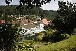 Bad Teinach, October 2012 | |
 Coat of arms | |
Location of Bad Teinach-Zavelstein within Calw district 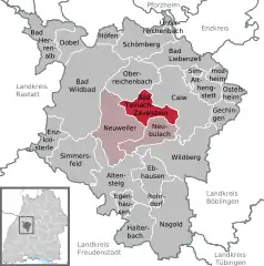 | |
 Bad Teinach-Zavelstein  Bad Teinach-Zavelstein | |
| Coordinates: 48°41′18″N 8°41′17″E | |
| Country | Germany |
| State | Baden-Württemberg |
| Admin. region | Karlsruhe |
| District | Calw |
| Area | |
| • Total | 25.1 km2 (9.7 sq mi) |
| Highest elevation | 650 m (2,130 ft) |
| Lowest elevation | 391 m (1,283 ft) |
| Population (2019-12-31)[1] | |
| • Total | 3,147 |
| • Density | 130/km2 (320/sq mi) |
| Time zone | UTC+01:00 (CET) |
| • Summer (DST) | UTC+02:00 (CEST) |
| Postal codes | 75385 |
| Dialling codes | 07053 |
| Vehicle registration | CW |
| Website | www |
History
The township of Bad Teinach-Zavelstein was formed on 1 January 1975 by the merging of Bad Teinach, Zavelstein, and the towns of Emberg, Rötenbach, Schmieh, and Sommenhardt.[2]
Geography
The township (Stadt) of Bad Teinach-Zavelstein is located at the center of the district of Calw, in Baden-Württemberg, one of the 16 States of the Federal Republic of Germany. Bad Teinach-Zavelstein's municipal area rests upon the plateau of the Enz and Nagold rivers, a landscape defined by severe river erosion, in the greater Black Forest region. Elevation above sea level in the municipal area ranges from a high of 747 meters (2,451 ft) Normalnull (NN) to a low of 337 meters (1,106 ft) NN.[2]
A portion of the Federally protected Zavelstein crocus meadows nature reserve is located in Bad Teinach-Zavelstein's municipal area.[2]
Politics
Bad Teinach-Zavelstein has six boroughs, Bad Teinach, Emberg, Rötenbach, Schmieh, Sommenhardt, and Zavelstein, and five villages, Kentheim, Kollwanger Sägmühle, Lützenhardt, Teinachtal, Wilhelmshöhe.[2]
Coat of arms
Bad Teinach-Zavelstein's municipal coat of arms is divided party per fess into an upper field of yellow with three black stag antlers, and a lower field of five yellow and red squares in a checkerboard pattern. The checkboard pattern is an archaic reference to the name Zavelstein using the word zabel, and the stag antlers are taken from the Coat of arms of Württemberg. This coat of arms was awarded by the Calw district office to Bad Teinach-Zavelstein with an accompanying municipal flag on 13 February 1981.[2]
Transportation
Bad Teinach-Zavelstein is connected to Germany's network of roadways by the Bundesstraße 463 and to its rail system by the Nagold Valley Railway. Local public transportation is provided by the Verkehrsgesellschaft Bäderkreis Calw.[2]
References
- "Bevölkerung nach Nationalität und Geschlecht am 31. Dezember 2019". Statistisches Landesamt Baden-Württemberg (in German). September 2020.
- "Bad Teinach-Zavelstein". LEO-BW (in German). Baden-Württemberg. Retrieved 31 July 2020.
External links
| Wikimedia Commons has media related to Bad Teinach-Zavelstein. |
- Official website
 (in German)
Towns and municipalities in Calw (district) | ||
|---|---|---|
| Authority control |
|---|