Egenhausen
Egenhausen is a town in the district of Calw in Baden-Württemberg in Germany.
Egenhausen | |
|---|---|
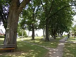 Egenhausen oak grove | |
 Coat of arms | |
Location of Egenhausen within Calw district 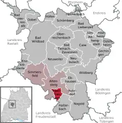 | |
 Egenhausen  Egenhausen | |
| Coordinates: 48°33′56″N 08°37′06″E | |
| Country | Germany |
| State | Baden-Württemberg |
| Admin. region | Karlsruhe |
| District | Calw |
| Area | |
| • Total | 10.01 km2 (3.86 sq mi) |
| Elevation | 535 m (1,755 ft) |
| Population (2019-12-31)[1] | |
| • Total | 2,046 |
| • Density | 200/km2 (530/sq mi) |
| Time zone | UTC+01:00 (CET) |
| • Summer (DST) | UTC+02:00 (CEST) |
| Postal codes | 72227 |
| Dialling codes | 07453 |
| Vehicle registration | CW |
| Website | www |
History
The villages of Egenhausen, Kapf, and Ölmühle were sold to the Duchy of Württemberg by the Margraviate of Baden in 1603. The three were governed from Altensteig until 1811, when they were assigned to Oberamt Nagold. The Oberamt was dissolved in 1938 and Egenhausen, Kapf, and Ölmühle were subsequently assigned to the new Landkreis Calw. Egenhausen began a period of urban growth after World War II and had developed two new neighborhoods at its northern and western extremities by the mid-1960s.[2]
Geography
The municipality (Gemeinde) of Egenhausen is located at the south-western edge of the district of Calw, in the German state of Baden-Württemberg. It lies along the border with the district of Freudenstadt to the south and west. Egenhausen is located in a transitional landscape between the Black Forest, the Heckengäu, and the Upper Gäu. Elevation above sea level in the municipal area ranges from a high of 626 meters (2,054 ft) Normalnull (NN) to a low of 458 meters (1,503 ft) NN.[2]
Portions of the Federally protected Egenhäuser Kapf at Bömbachtal and Upper Gründel nature reserves are located in Egenhausen's municipal area.[2]
Politics
Egenhausen has one borough (Ortsteil), Egenhausen, and two villages: Kapf and Ölmühle. There is also an abandoned village, Sindelsteta, in the municipal area. Egenhausen is a member of the Altensteig Municipal Association with the city of Altensteig and the municipality of Simmersfeld.[2]
Coat of arms
Egenhausen's coat of arms portrays a thistle, in yellow a white flower and six yellow leaves, rooted to a field of red. The thistle is a reference to the flora of the Heckengäu. This coat of arms was awarded to Egenhausen by the Federal Ministry of the Interior alongside a municipal flag on 10 April 1969.[2]
Transportation
Egenhausen is connected to Germany's network of roadways by Bundesstraße 28. Local public transportation is provided by the Verkehrsgesellschaft Bäderkreis Calw.[2]
References
- "Bevölkerung nach Nationalität und Geschlecht am 31. Dezember 2019". Statistisches Landesamt Baden-Württemberg (in German). September 2020.
- "Egenhausen". LEO-BW (in German). Baden-Württemberg. Retrieved 31 July 2020.
External links
| Wikimedia Commons has media related to Egenhausen. |
- Official website
 (in German)
Towns and municipalities in Calw (district) | ||
|---|---|---|
