Balagny-sur-Thérain
Balagny-sur-Thérain is a commune in the Oise department in northern France.
Balagny-sur-Thérain | |
|---|---|
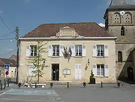 Town hall | |
 Coat of arms | |
Location of Balagny-sur-Thérain 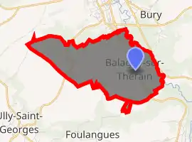
| |
 Balagny-sur-Thérain  Balagny-sur-Thérain | |
| Coordinates: 49°17′46″N 2°20′14″E | |
| Country | France |
| Region | Hauts-de-France |
| Department | Oise |
| Arrondissement | Senlis |
| Canton | Montataire |
| Government | |
| • Mayor (2008–2014) | Cécile Bremard |
| Area 1 | 6.8 km2 (2.6 sq mi) |
| Population (2017-01-01)[1] | 1,723 |
| • Density | 250/km2 (660/sq mi) |
| Time zone | UTC+01:00 (CET) |
| • Summer (DST) | UTC+02:00 (CEST) |
| INSEE/Postal code | 60044 /60250 |
| Elevation | 33–116 m (108–381 ft) (avg. 39 m or 128 ft) |
| 1 French Land Register data, which excludes lakes, ponds, glaciers > 1 km2 (0.386 sq mi or 247 acres) and river estuaries. | |
Population
|
|
See also
References
- "Populations légales 2017". INSEE. Retrieved 6 January 2020.
| Wikimedia Commons has media related to Balagny-sur-Thérain. |
| Authority control |
|
|---|
This article is issued from Wikipedia. The text is licensed under Creative Commons - Attribution - Sharealike. Additional terms may apply for the media files.