Monchy-Humières
Monchy-Humières is a commune in the Oise department in northern France.
Monchy-Humières | |
|---|---|
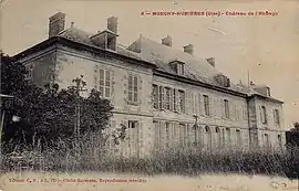 The old abbey house in Monchy | |
Location of Monchy-Humières 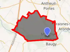
| |
 Monchy-Humières  Monchy-Humières | |
| Coordinates: 49°28′14″N 2°45′10″E | |
| Country | France |
| Region | Hauts-de-France |
| Department | Oise |
| Arrondissement | Compiègne |
| Canton | Estrées-Saint-Denis |
| Intercommunality | Pays des Sources |
| Government | |
| • Mayor (2014–2020) | Jean-Pierre Vrancken |
| Area 1 | 7.8 km2 (3.0 sq mi) |
| Population (2017-01-01)[1] | 769 |
| • Density | 99/km2 (260/sq mi) |
| Time zone | UTC+01:00 (CET) |
| • Summer (DST) | UTC+02:00 (CEST) |
| INSEE/Postal code | 60408 /60113 |
| Elevation | 41–111 m (135–364 ft) (avg. 52 m or 171 ft) |
| 1 French Land Register data, which excludes lakes, ponds, glaciers > 1 km2 (0.386 sq mi or 247 acres) and river estuaries. | |
History
The original Chateau de Monchy-Humières was destroyed during the 1337 to 1453 Hundred Years War and rebuilt in the 16th century. In 1595, it passed into the family of Louis de Crevant, duc d'Humières (1628-1694); the extensive ornamental gardens he laid out no longer exist but the Chateau still functions as a hotel/golf-club.
Many family members were buried in nearby church of St Martin de Monchy-Humières but as elsewhere, the memorials were destroyed during the French Revolution. In 1936, a sale of contents from the chateau included a full-length marble tomb which had been used as a garden ornament. Long thought to be of Louis de Crevant, it was in fact that of Jean III d'Humières (died 1553) by the sculptor Pierre Bontemps and is now in the Louvre.[2]
See also
References
- "Populations légales 2017". INSEE. Retrieved 6 January 2020.
- Penin, Marie Christine. "Humières, Louis de Crévant, Marquis, later duc". Tombes-sepultures. Retrieved 28 January 2019.
| Wikimedia Commons has media related to Monchy-Humières. |
| Authority control |
|---|