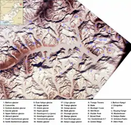
Baltoro Muztagh
The Baltoro Muztagh (simplified Chinese: 巴尔托洛慕士塔格山; traditional Chinese: 巴爾托洛慕士塔格山; pinyin: Bā'ěrtuōluò Mùshìtǎgé Shān, Urdu: بلتورو موز تاغ) is a subrange of the Karakoram mountain range, in Baltistan region of the Gilgit-Baltistan, northernmost political entity of Pakistan; and in Xinjiang, China. The crest of the range forms part of the Pakistan-China border.
| Baltoro Muztagh | |
|---|---|
 | |
| Highest point | |
| Peak | K2 |
| Elevation | 8,611 m (28,251 ft) |
| Coordinates | 35°52′57″N 76°30′48″E |
| Geography | |
| Countries | Pakistan and China |
| Regions | Gilgit-Baltistan and Xinjiang |
| Parent range | Karakoram |
The range is home to K2 (8,611 metres (28,251 ft)), the second highest mountain in the world, and to three other Eight-thousander peaks. They are located on the north and east sides of the Baltoro Glacier.
Selected peaks of the Baltoro Muztagh
The following is a table of the peaks in the Baltoro Muztagh which are over 7,200 metres (23,620 ft) in elevation and have over 500 metres (1,640 ft) of topographic prominence. (This is a common criterion for peaks of this stature to be independent.)
| Mountain | Height (m) | Height (ft) | Coordinates | Prominence (m) | Parent mountain | First ascent | Ascents (attempts) |
|---|---|---|---|---|---|---|---|
| K2 | 8,611 | 28,251 | 35°52′57″N 76°30′48″E | 4,017 | Mount Everest | 1954 | 45 (44) |
| Gasherbrum I | 8,080 | 26,509 | 35°43′27″N 76°41′44″E | 2,155 | K2 | 1958 | 31 (16) |
| Broad Peak | 8,051 | 26,414 | 35°48′38″N 76°34′05″E | 1,701 | Gasherbrum I | 1957 | 39 (19) |
| Gasherbrum II | 8,034 | 26,362 | 35°45′27″N 76°39′11″E | 1,523 | Gasherbrum I | 1956 | 54 (12) |
| Gasherbrum IV | 7,932 | 26,024 | 35°45′33″N 76°36′57″E | 725 | Gasherbrum III | 1958 | 4 (11) |
| Skyang Kangri | 7,545 | 24,754 | 35°55′35″N 76°34′03″E | 1,060 | K2 | 1976 | 1 (2) |
| Sia Kangri | 7,422 | 24,350 | 35°39′48″N 76°45′45″E | 640 | Gasherbrum I | 1934 | 6 (0) |
| Skil Brum | 7,410 | 24,311 | 35°51′03″N 76°25′45″E | 1,152 | K2 | 1957 | 2 (1) |
| Chongtar Kangri | 7,315 | 23,999 | 35°54′46″N 76°25′47″E | 1,300 | Skil Brum | 1994 | 1 (1) |
| Muztagh Tower | 7,276 | 23,871 | 35°49′38″N 76°21′39″E | 1,710 | Skil Brum | 1956 | 4 (2) |
Lower summits
There are a number of lower summits near the tongue of the Baltoro Glacier which are striking rock towers, and are famous for their aesthetic, difficult climbing. These include:
- Great Trango, 6,286 m
- Trango (Nameless) Tower, 6,239 m
- Uli Biaho Tower, 6,109 m
See also
| Wikimedia Commons has media related to Baltoro Muztagh. |
- List of highest mountains
- List of mountains in Pakistan
Sources
Jerzy Wala, Orographical Sketch Map of the Karakoram, Swiss Foundation for Alpine Research, Zurich, 1990.