Barbuise
Barbuise is a commune in the Aube department in the Grand Est region of north-central France.[2]
Barbuise | |
|---|---|
 | |
Location of Barbuise 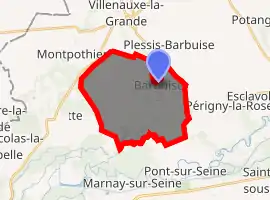
| |
 Barbuise  Barbuise | |
| Coordinates: 48°33′32″N 3°34′39″E | |
| Country | France |
| Region | Grand Est |
| Department | Aube |
| Arrondissement | Nogent-sur-Seine |
| Canton | Nogent-sur-Seine |
| Intercommunality | Nogentais |
| Government | |
| • Mayor (2020–2026) | Alain Boyer |
| Area 1 | 18.09 km2 (6.98 sq mi) |
| Population (2017-01-01)[1] | 465 |
| • Density | 26/km2 (67/sq mi) |
| Time zone | UTC+01:00 (CET) |
| • Summer (DST) | UTC+02:00 (CEST) |
| INSEE/Postal code | 10031 /10400 |
| 1 French Land Register data, which excludes lakes, ponds, glaciers > 1 km2 (0.386 sq mi or 247 acres) and river estuaries. | |
The inhabitants of the commune are known as Barbisiens or Barbisiennes.[3]
Geography
Barbuise is located some 45 km north-west of Troyes and 20 km east of Provins. Access to the commune is by the D40 from La Villeneuve-au-Châtelot in the east which passes through the heart of the commune south of the village and continues west then south-west to join the D40A to Chalautre-la-Grande. The D52 comes from Villenauxe-la-Grande in the north and passes through the village before continuing south-east to Pont-sur-Seine. The D97 goes north-west from the village to Montpothier. The D174 branches off the D97 west of the village and goes north to Plessis-Barbuise. The D197 connects the D40 and the D97 in the west of the commune. The commune is almost all farmland with many lakes occupying a significant area of land in a belt across the commune and in the south-east.[4][5]
The Canal de Courtavant crosses the south-east of the commune from south-west to north-east. The Noxe river flows from the north passing near the village and joins the canal. The Canal de Soulaunoy joins the Noxe south-west of the village.[4]
Neighbouring communes and villages | |
|---|---|
History
The area of the commune has been occupied since ancient times as evidenced by many archaeological discoveries and megaliths in the commune.
Barbuise appears as Barbuife on the 1750 Cassini Map[6] and as Barbuise on the 1790 version.[7]
Administration
| From | To | Name | Party | Position |
|---|---|---|---|---|
| 1857 | Dupont | |||
| 1887 | Célestin Denis | |||
| 2001 | 2020 | Alain Boyer |
(Not all data is known)
Demography
In 2017 the commune had 465 inhabitants.
|
| ||||||||||||||||||||||||||||||||||||||||||||||||||||||||||||||||||||||||||||||||||||||||||||||||||||||||||||||||||
| Source: EHESS[9] and INSEE[10] | |||||||||||||||||||||||||||||||||||||||||||||||||||||||||||||||||||||||||||||||||||||||||||||||||||||||||||||||||||
Sites and monuments
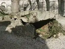
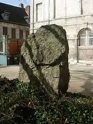
- The Dolmen of Grèves de Fraicul (Neolithic)
 is registered as an historical monument.[11] were a part of Cerny culture.
 - The parish church contains a large number of items that are registered as historical objects. For a complete list including links to descriptions (in French) click here.
See also
References
- "Populations légales 2017". INSEE. Retrieved 6 January 2020.
- Barbuise on Lion1906
- Inhabitants of Aube (in French)
- Barbuise on Google Maps
- Barbuise on the Géoportail from National Geographic Institute (IGN) website (in French)
- Barbuiſe on the 1750 Cassini Map
- Barbuise on the 1790 Cassini Map
- List of Mayors of France (in French)
- Données Cassini, EHESS
- Population en historique depuis 1968, INSEE
- Ministry of Culture, Mérimée PA00125372 Dolmen (in French)
| Wikimedia Commons has media related to Barbuise. |
| Authority control |
|---|