Bar-sur-Seine
Bar-sur-Seine is a commune in the Aube department in the Grand Est region of north-central France.[2]
Bar-sur-Seine | |
|---|---|
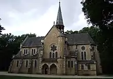
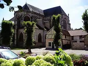 St Stephen's Church | |
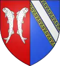 Coat of arms | |
Location of Bar-sur-Seine 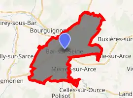
| |
 Bar-sur-Seine  Bar-sur-Seine | |
| Coordinates: 48°06′53″N 4°22′36″E | |
| Country | France |
| Region | Grand Est |
| Department | Aube |
| Arrondissement | Troyes |
| Canton | Bar-sur-Seine |
| Intercommunality | Barséquanais |
| Government | |
| • Mayor (2020–2026) | Dominique Baroni |
| Area 1 | 27.53 km2 (10.63 sq mi) |
| Population (2017-01-01)[1] | 3,018 |
| • Density | 110/km2 (280/sq mi) |
| Time zone | UTC+01:00 (CET) |
| • Summer (DST) | UTC+02:00 (CEST) |
| INSEE/Postal code | 10034 /10110 |
| Elevation | 147–293 m (482–961 ft) |
| 1 French Land Register data, which excludes lakes, ponds, glaciers > 1 km2 (0.386 sq mi or 247 acres) and river estuaries. | |
The inhabitants of the commune are known as Barrois or Barroises and Barséquanais or Barséquanaises.[3]
The commune has been awarded three flowers by the National Council of Towns and Villages in Bloom in the Competition of cities and villages in Bloom.[4]
Geography
Bar-sur-Seine is located some 20 km south-east of Troyes and 25 km north-west of Montliot-et-Courcelles. Access to the commune is by the D671 road from Virey-sous-Bar in the north-west which passes through the town and continues south-east to Celles-sur-Ource. The D443 comes from Magnant in the north-east also passing through the village and continuing south-west to Villemorien. The D63 also goes to Magnant by a slightly longer route. The D4 goes from the town to Ville-sur-Arce in the south-east. The D49 branches from the D443 on the right bank of the Seine and goes north-west to Courtenot. There is also the railway passing through the commune from Saint-Parres-lès-Vaudes in the north-east and continuing to the next station at Polisot in the south-east. Apart from the town there are the hamlets of Avaleur and La Bordé. There are large forests to the north-east and south-west of the town with the rest of the commune farmland.[5][6]
The Seine river flows through the commune and the town from south-east to north-west and continues north-west to Troyes and beyond. The Ource river flows from the south-east and forms part of the south-eastern border before joining the Seine at the border of the commune. The Arce river joins the Seine on the right bank on the south-eastern border of the commune.[5][6]
Neighbouring communes and villages[5] | |
|---|---|
Toponymy
Bar is a Gallic word and perhaps even pre-Gallic which means "summit" or "height".[7]
History
The town was devastated in 1359 by the English, when, according to Froissart, no fewer than 900 mansions were burnt. Afterwards it suffered greatly in the religious wars of the 16th century.[8]
Bar-sur-Seine was the chief town of the district in 1790 and then sub-prefecture from 1800 until 1926.
Bar-sur-Seine minted deniers under Charles the Bald.
Under the Ancien Regime Bar-sur-Seine was located in the province of Burgundy.
Bar-sur-Seine appears as Bar ſur Seine, with a long s, on the 1750 Cassini Map[9] and the same on the 1790 version.[10]
Heraldry
Arms of Bar-sur-Seine |
The official status of the blazon remains to be determined.
Blazon: |
Administration
| From | To | Name | Party | Position |
|---|---|---|---|---|
| 1857 | Charles François Bourbonne | |||
| 2001 | 2008 | Jean Weinling | ||
| 2008 | 2020 | Marcel Hurillon |
(Not all data is known)
Education
The commune has seven educational establishments:[12]
- Public Kindergarten of 14 July
- Henri Breton private primary school
- Georges Leclerc public primary school
- Maurice Robert public primary school
- Henri Breton College
- Paul Portier College
- Lycée professionnel du Val Moré
Demography
In 2017 the commune had 3,018 inhabitants.
|
| ||||||||||||||||||||||||||||||||||||||||||||||||||||||||||||||||||||||||||||||||||||||||||||||||||||||||||||||||||
| Source: EHESS[13] and INSEE[14] | |||||||||||||||||||||||||||||||||||||||||||||||||||||||||||||||||||||||||||||||||||||||||||||||||||||||||||||||||||
Economy
Most Champagne vines are grown in the Marne department (on Cretaceous land) in the Marne valley (to the west of Château-Thierry) and on a series of lands straddling the Tertiary and Cretaceous (Avize, Vertus, Sézanne etc.)
Champagnes of Aube are very eccentric and very southern compared to other Champagnes and are grown on Jurassic lands which makes them distinctive. This area of Aube Champagnes includes other neighbouring communes such as Les Riceys and Bar-sur-Aube.
Culture and heritage
Civil heritage
The commune has a number of buildings and sites that are registered as historical monuments:
- The Boulard Stationery factory (19th century)
 [15]
[15] - The Charrier Mill (19th century)[16]
- The Bar-sur-Seine Glass and Crystal Works (1881)[17]
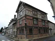
- A Timbered House at Rue Victor-Hugo (16th century)[18]
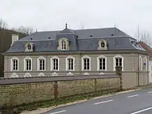
- The Domain of Villeneuve at Villeneuve (1874)[19]
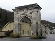
- The Portal of Châtillon (17th century)[20]
- The Chateau of the Counts of Bar (13th century)[21]
Religious heritage
The commune has two religious buildings and sites that are registered as historical monuments:
The commune contains a very large number of religious objects that are registered as historical objects. Most of these items are in the Church of Saint Stephen but with many items in other locations. For a complete list of these items together with links to descriptions (in French) and some photos click here.
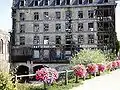 The old Mill
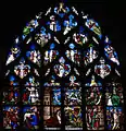 Stained glass in the Church of Saint Stephen
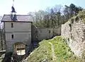 Chateau of the Counts of Bar
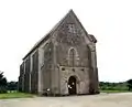 The Templar Commanderie at Avalleur
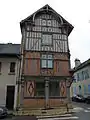 The Timbered House
See also
References
- "Populations légales 2017". INSEE. Retrieved 6 January 2020.
- Bar-sur-Seine on Lion1906
- Inhabitants of Aube (in French)
- Competition for Towns and Villages in Bloom website Archived December 10, 2014, at the Wayback Machine (in French)
- Bar-sur-Seine on Google Maps
- Bar-sur-Seine on the Géoportail from National Geographic Institute (IGN) website (in French)
- Albert Dauzat and Charles Rostaing, Etymological Dictionary of place names in France, Larousse, Paris, 1963 (in French)
-
 One or more of the preceding sentences incorporates text from a publication now in the public domain: Chisholm, Hugh, ed. (1911). "Bar-sur-Seine". Encyclopædia Britannica. 3 (11th ed.). Cambridge University Press. p. 446.
 - Bar fur Seine on the 1750 Cassini Map
- Bar fur Seine on the 1790 Cassini Map
- List of Mayors of France (in French)
- Schools in Bar-sur-Seine (in French)
- Des villages de Cassini aux communes d'aujourd'hui: Commune data sheet Bar-sur-Seine, EHESS. (in French)
- Population en historique depuis 1968, INSEE
- Ministry of Culture, Mérimée IA10000004 Boulard Stationery factory (in French)
- Ministry of Culture, Mérimée IA10000049 Boulard Charrier Mill (in French)
- Ministry of Culture, Mérimée IA10000003 Bar-sur-Seine Glass and Crystal Works (in French)
- Ministry of Culture, Mérimée PA00078046 Timbered House
 (in French)
 - Ministry of Culture, Mérimée PA00132583 Domain of Villeneuve (in French)
- Ministry of Culture, Mérimée PA00078047 Portal of Châtillon (in French)
- Ministry of Culture, Mérimée PA00078044 Chateau of the Counts of Bar (in French)
- Ministry of Culture, Mérimée PA00078045 Church of Saint Stephen (in French)
- Ministry of Culture, Mérimée PA00078043 Chapel of Avalleur (in French)
External links
| Wikimedia Commons has media related to Bar-sur-Seine. |
| Authority control |
|---|