Barjols
Barjols is a commune in the Var department in the Provence-Alpes-Côte d'Azur region in southeastern France.
Barjols | |
|---|---|
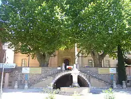 Maison Régionale de l'eau | |
.svg.png.webp) Coat of arms | |
Location of Barjols 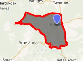
| |
 Barjols  Barjols | |
| Coordinates: 43°33′32″N 6°00′29″E | |
| Country | France |
| Region | Provence-Alpes-Côte d'Azur |
| Department | Var |
| Arrondissement | Brignoles |
| Canton | Saint-Maximin-la-Sainte-Baume |
| Government | |
| • Mayor (2008–2014) | Daniel Nironi |
| Area 1 | 30.06 km2 (11.61 sq mi) |
| Population (2017-01-01)[1] | 2,979 |
| • Density | 99/km2 (260/sq mi) |
| Time zone | UTC+01:00 (CET) |
| • Summer (DST) | UTC+02:00 (CEST) |
| INSEE/Postal code | 83012 /83670 |
| Elevation | 183–473 m (600–1,552 ft) (avg. 259 m or 850 ft) |
| 1 French Land Register data, which excludes lakes, ponds, glaciers > 1 km2 (0.386 sq mi or 247 acres) and river estuaries. | |
At the gateway to Haute Provence and the hills of Var, near the Verdon gorges and the Lake of St. Croix, the town is set on a limestone cliff. Featuring 42 fountains, Barjols' architecture and life have been determined for centuries by the omnipresence of water. Historical buildings include the 11th century Collegiate Church. Leather was the mainstay of the village economy until the late 20th century when production moved to emerging economies and decline set in. Owing to this more recent industry, Barjols did not embrace tourism, and has kept many features and characters of French village life.
Sites of interest
- The Collegiate Church of Notre Dame de I'Assomption,
- Portal of Ponteves
- Regional Water Museum
- The fountains
- Vineyards
Neighbouring villages
- Tavernes (5 km),
- Varages (7 km),
- Châteauvert (8 km),
- Cotignac (15 km)
- Brue Auriac (10 km).
See also
References
- "Populations légales 2017". INSEE. Retrieved 6 January 2020.
| Wikimedia Commons has media related to Barjols. |
| Authority control |
|---|
This article is issued from Wikipedia. The text is licensed under Creative Commons - Attribution - Sharealike. Additional terms may apply for the media files.