Puget-sur-Argens
Puget-sur-Argens (French pronunciation: [pyʒe syʁ‿aʁʒɛ̃(s)] (![]() listen), literally Puget on Argens; Occitan: Lo Puget d'Argenç) is a commune in the Var department in the Provence-Alpes-Côte d'Azur region in southeastern France.
listen), literally Puget on Argens; Occitan: Lo Puget d'Argenç) is a commune in the Var department in the Provence-Alpes-Côte d'Azur region in southeastern France.
Puget-sur-Argens | |
|---|---|
 The bell tower of Puget-sur-Argens | |
.svg.png.webp) Coat of arms | |
Location of Puget-sur-Argens 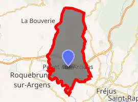
| |
 Puget-sur-Argens  Puget-sur-Argens | |
| Coordinates: 43°27′23″N 6°40′58″E | |
| Country | France |
| Region | Provence-Alpes-Côte d'Azur |
| Department | Var |
| Arrondissement | Draguignan |
| Canton | Roquebrune-sur-Argens |
| Government | |
| • Mayor (2020–2026) | Paul Boudoube |
| Area 1 | 26.9 km2 (10.4 sq mi) |
| Population (2017-01-01)[1] | 8,097 |
| • Density | 300/km2 (780/sq mi) |
| Time zone | UTC+01:00 (CET) |
| • Summer (DST) | UTC+02:00 (CEST) |
| INSEE/Postal code | 83099 /83480 |
| Elevation | 0–180 m (0–591 ft) (avg. 12 m or 39 ft) |
| 1 French Land Register data, which excludes lakes, ponds, glaciers > 1 km2 (0.386 sq mi or 247 acres) and river estuaries. | |
It is located at 687 kilometres south-east of Paris. It is called Lo Pugeton or Lo Puget d'Argènç in Occitan and Le Petit Puget in the province to distinguish it from the city formerly more important from Puget-Ville. and is located at the crossing of the Route nationale 7 and the A8 autoroute. The population of Puget-on-Argens has multiplied by four since 1950 and many companies have come to the town. In fact, the strong demographic and economic expansion in direct periphery tends to transform the commune into a suburban residential and working area. Its inhabitants are called Pugétois.[2]
Demographics
| Year | 1962 | 1968 | 1975 | 1982 | 1990 | 1999 | 2007 | 2012 | 2017 |
|---|---|---|---|---|---|---|---|---|---|
| Population | 3399 | 3033 | 3849 | 4509 | 5865 | 6371 | 6988 | 6915 | 8097 |
Climate
| Climate data for Puget-sur-Argens | |||||||||||||
|---|---|---|---|---|---|---|---|---|---|---|---|---|---|
| Month | Jan | Feb | Mar | Apr | May | Jun | Jul | Aug | Sep | Oct | Nov | Dec | Year |
| Average high °C (°F) | 13 (55) |
13 (55) |
15 (59) |
18 (64) |
21 (70) |
25 (77) |
28 (82) |
28 (82) |
25 (77) |
21 (70) |
16 (61) |
13 (55) |
19.6 (67.3) |
| Daily mean °C (°F) | 8 (46) |
9 (48) |
10 (50) |
13 (55) |
16 (61) |
19 (66) |
22 (72) |
22 (72) |
19 (66) |
16 (61) |
11 (52) |
8 (46) |
14.4 (57.9) |
| Average low °C (°F) | 3 (37) |
4 (39) |
5 (41) |
7 (45) |
10 (50) |
14 (57) |
16 (61) |
16 (61) |
14 (57) |
11 (52) |
6 (43) |
3 (37) |
9.1 (48.4) |
| Average precipitation mm (inches) | 89.6 (3.53) |
85.4 (3.36) |
72.3 (2.85) |
62.1 (2.44) |
48.7 (1.92) |
37.9 (1.49) |
14.6 (0.57) |
42.6 (1.68) |
59.0 (2.32) |
117.0 (4.61) |
108.9 (4.29) |
85.6 (3.37) |
823.4 (32.42) |
| Mean monthly sunshine hours | 147.8 | 148.9 | 203.2 | 252.1 | 234.9 | 280.6 | 310.3 | 355.5 | 319.5 | 247.0 | 201.5 | 145.5 | 2,748.1 |
| Source: [5] | |||||||||||||
See also
References
- "Populations légales 2017". INSEE. Retrieved 6 January 2020.
- "Gentilé on the site habitants.fr". Archived from the original on 2008-05-22. Retrieved 2008-06-26.
- Des villages de Cassini aux communes d'aujourd'hui: Commune data sheet Puget-sur-Argens, EHESS. (in French)
- Population en historique depuis 1968, INSEE
- "Archives climatologiques mensuelles - Saint-Raphaël (1961-1990)". Archived from the original on 2008-12-09. Retrieved 2008-06-26.
| Wikimedia Commons has media related to Puget-sur-Argens. |
External links
| Authority control |
|---|