Barney's Junction, Washington
Barney's Junction is a census-designated place in Ferry County, Washington, in the United States.
Barney's Junction, Washington | |
|---|---|
 Barney's Junction  Barney's Junction | |
| Coordinates: 48°37′24″N 118°07′34″W | |
| Country | United States |
| State | Washington |
| County | Pierce |
| Area | |
| • Total | 0.26 sq mi (0.67 km2) |
| • Land | 0.26 sq mi (0.67 km2) |
| • Water | 0.0 sq mi (0.0 km2) |
| Elevation | 1,365 ft (416 m) |
| Population (2010) | |
| • Total | 146 |
| • Density | 561/sq mi (216.6/km2) |
| Time zone | Pacific |
| Area code(s) | 360 |
Geography
Barney's Junction is located in eastern Ferry County at coordinates 48°37′24″N 118°07′34″W, on the west side of the Columbia River. U.S. Route 395 crosses the river at the north end of the CDP, leading east 3.5 miles (5.6 km) to Kettle Falls in Stevens County. To the north US 395 leads 28 miles (45 km) to the Canadian border at Laurier. Washington State Route 20 intersects US 395 at Barney's Junction, and leads generally west 40 miles (64 km) over Sherman Creek Pass in Colville National Forest to Republic, the Ferry County seat.
According to the U.S. Census Bureau, the Barney's Junction CDP has a total area of 0.26 square miles (0.67 km2), all of it land.
References
- "Geographic Identifiers: 2010 Demographic Profile Data (G001): Barney's Junction CDP, Washington". U.S. Census Bureau, American Factfinder. Retrieved October 20, 2016.
- "Barney's Junction, Washington". Retrieved 19 August 2014.
Municipalities and communities of Ferry County, Washington, United States | ||
|---|---|---|
| City | 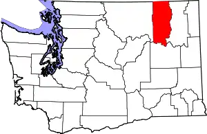 Map of Washington highlighting Ferry County | |
| CDPs | ||
| Other unincorporated communities | ||
| Indian reservation | ||
| Ghost town | ||
| Footnotes | ‡This populated place also has portions in an adjacent county or counties | |
| ||