Barwani
Barwani or Badwani (Hindi: Baḍwāni) is a municipal town in Barwani district of Madhya Pradesh, India, that is situated near the left bank of the Narmada River. It is the administrative headquarters of Barwani district and has also served as the capital of the former princely state of Barwani. Barwani is only accessible by road.
Barwani | |
|---|---|
| Nickname(s): | |
 Barwani  Barwani | |
| Coordinates: 22.03°N 74.9°E | |
| Country | |
| State | Madhya Pradesh |
| Region | Nimar |
| District | Barwani district |
| Government | |
| • Type | Municipal council |
| • Body | Municipal Council of Barwani |
| • Chairperson | Lakshman Singh Chauhan (INC) |
| Area | |
| • Total | 27 km2 (10 sq mi) |
| Elevation | 178 m (584 ft) |
| Population (2011) | |
| • Total | 55,504 |
| • Density | 2,100/km2 (5,300/sq mi) |
| Demonym(s) | Nimadi |
| Languages | |
| • Official | |
| • Regional | |
| Time zone | UTC+5:30 (IST) |
| PIN | 451551 |
| Telephone code | 07290 |
| Vehicle registration | MP-46 |
| Website | barwani |
Origin of name
The name Barwani originated from the words Bad and Wani. The Forests of "Bad" surrounded the city in old times and "Wani" is an old word meaning "the garden", translating to the Garden of Bad. Despite its official spelling, Barwani is pronounced as "Badwani".[1]
Geography
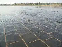
Barwani is located at 22.03°N 74.9°E.[2] It has an average elevation of 178 meters (583 feet). The Narmada River flows through Barwani; it is 5 km (3.1 miles) from the city centre. The maximum temperature of Barwani in April and May used to reach 48 °C (118 °F), making it one of the hottest places in Central India. However, in recent years, it has cooled down.

The hills of the Satpura Range surround Barwani. The city is also called the "Paris of Nimar" ("area beyond Neem trees").[3] Nimar is split into East Nimar and West Nimar; Barwani lies in West Nimar. The annual rainfall of Barwani is around {{Convert|15|inches|cm|abbr=on), though since 2006 it has increased significantly. Barwani is famous for its papayas and Bawangaja, a Jain holy place 8 km (5.0 miles) from Barwani.
Transport

Barwani has no immediate connectivity through rail but is easily accessible via roadways.
Railways
barwani has no direct rail connectivity[ the nearest station to the town is at Indore. Western Railways (Ratlam Mandal) has a reservation counter in Ambedkar Park on Rajghat Road. There is also a railway station at Khandwa on the Central Railway, which is 180 km (110 miles) from Barwani via State Highway 26.[4]
Roads
Barwani is well connected to other parts of Madhya Pradesh and other states via national and state highways. The town is connected to the Agra-Bombay national highway number three by the Khandwa-Baroda interstate highway no. 26 at a distance of 51 km (32 miles) at Thikri. Bus services connect the town with the major and minor cities near Barwani, including Indore, Khandwa, Ujjain, Dewas, Dhar, Ratlam, Khargone, Harda, Mumbai, Ahmedabad, and Vadodara.
Demographics
As of the 2011 Census of India,[4] Barwani had a population of 55,504, consisting of 28,437 males (51%) and 27,067 females (49%).
The population of children aged 0–6 was 6,961 (12.54%). In Barwani Municipality, the male-to-female female sex ratio is 1,000:952 against the state average of 1,000:931. The child male-to-female sex ratio in Barwani is around 1000:919, compared with the Madhya Pradesh state average of 1000:918. The literacy rate of Barwani City is 82.10% compared with the state's average of 69.32%. In Barwani, male literacy is around 87.17%, while the female literacy rate is 76.80%.
Schedule Tribes (ST) constitutes 23.29% while Schedule Castes (SC) were 9.95% of the population in Barwani.[5]
Out of the total population, 18,438 were engaged in work or business activity. Of these, 13,957 were males and 4,481 were females. In a census survey, a worker is defined as a person who does business, job, service, and cultivator and labour activity. With 18,438 people in the working population, 89.06% were engaged in Main Work while 10.94% of total workers were engaged in Marginal Work.[5]
Economy
Economically, Barwani engages in agricultural crops and wood,[6] with several other small industries developing in the area.
Culture
Main festivals
The major festivals of Holi, Raksha Bandhan, Ganesh Utsav, Navratri, Dussehra, Deepavali, Muharram, Gudi Padwa, Gangore, Bhaidooj, Eid al-Fitr and Eid al-Adha, Christmas and Naga Panchami are all celebrated with equal enthusiasm. Barwani is known for jhakis (झाकी) (glimpse or view) during Ganesh Utsav and Tajiye during Muharram.
Places of interest
- Bawangaja (Jain Mandir)
- Rajghat (Narmada River)
Healthcare
Barwani is prominent in the Nimar and Malwa regions for its healthcare facilities and its private hospitals. Barwani District Hospital is one of the oldest hospitals in Madhya Pradesh.
Notable people
- Dr. Anil Kakodkar, India's eminent nuclear physicist, and former chairman of the Atomic Energy Commission of India and the Secretary to the Government of India, Department of Atomic Energy, was born in Barwani.
Gallery
 Vaishno Devi Mandir during festival, Barwani
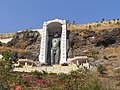 84 feet tall, huge statue of Bhagwan Rishabhadeva at Bawangaja
 Beauty of Satpura Hills
 Beautiful Satpura Hills, Barwani
 Choolgiri View from forest point
 MAA VAISHNO DEVI MANDIR
References
- "Barwani/District Court in India | Official Website of District Court of India". districts.ecourts.gov.in. Retrieved 26 July 2020.
- Falling Rain Genomics, Inc - Barwani
- "Profile | District Barwani, Government of Madhya Pradesh | India". Retrieved 30 July 2020.
- "Census of India 2011: Data from the 2011 Census, including cities, villages and towns (Provisional)". Census Commission of India. Retrieved 18 June 2015.
- http://www.census2011.co.in/data/town/802285-barwani-madhya-pradesh.html
- "Barwani | India". Encyclopedia Britannica. Retrieved 31 July 2020.