Battambang Province
Battambang (Khmer: បាត់ដំបង, IPA: [ˌɓat ɗɑm ˈɓɑːŋ], 'lost stick') is a province (khaet) of Cambodia in the far northwest of the country. Bordering provinces are Banteay Meanchey to the north, Pursat to the east and south, Siem Reap to the northeast, and Pailin to the west. The northern and southern extremes of the province's western boundaries form part of the international border with Thailand. In addition, Tonle Sap forms part of the northeastern boundary between Siem Reap and Pursat. Its capital and largest city is Battambang.
Battambang Province
បាត់ដំបង | |
|---|---|
.jpg.webp) 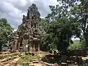   | |
 Seal | |
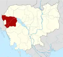 Map of Cambodia highlighting Battambang Province | |
| Country | |
| Siamese administration | 1795–1907 |
| Provincial status | 6 December 1907 |
| Capital | Battambang Municipality |
| Government | |
| • Governor | Nguon Ratanak (CPP) |
| Area | |
| • Total | 11,702 km2 (4,518 sq mi) |
| Area rank | 5th |
| Population (2019)[1] | |
| • Total | |
| • Rank | 5th |
| • Density | 85/km2 (220/sq mi) |
| • Density rank | 16th |
| Time zone | UTC+7 (ICT) |
| ISO 3166 code | KH-2 |
| Website | battambang |
It is the fifth most populous province in Cambodia.[1] In land area, Battambang is the fifth largest province of Cambodia. Battambang is one of the provinces included in the Tonle Sap Biosphere Reserve.[2] The province's fertile rice fields have led to a mostly agricultural economy giving rise to the moniker "the rice bowl of Cambodia". The province features a range of cultures as well as natural resources. Seventy five percent of the area is jungles and mountains. The area has a tropical climate.
Etymology
Battambang literally means 'loss of staff or stick' in Khmer, referring to the local legend of Preah Bat Dambang Kranhoung. Stone inscriptions discovered from pre-Angkorian and Angkorian eras have as yet not mentioned any contemporary villages or districts called "Battambang", but according to the document Mohachun Khmer, Srok Battambang (Battambang District) was used during the Angkor and post-Angkor eras. In Thai, the province is called Phra Tabong.
Battambang was annexed by both Siam and Cambodia from time to time because its location is in between both kingdoms. Majority of the locals is Khonpor or Chong ethnicity, a part of Austro-Asiatic family.
In 1769, Battambang and Siem Reap were conquered by King Taksin of Siam. In 23rd ogf March 1907, Battambang, with Siem Reap and Koh Kong, were annexed to French Indochina. During the world war II, it was annexed to Imperial Japan then handed over to Thailand. After the world war ended, it returned to the independent Cambodia.
Administrative divisions
Battambang is divided into 13 districts and one municipality which are further subdivided into 92 communes (Khmer: ឃុំ, khum), 10 sangkats (Khmer: សង្កាត់) and 810 villages (Khmer: ភូមិ, phum).
| ISO Code | District | Khmer |
|---|---|---|
| 02-01 | Banan | ស្រុកបាណន់ |
| 02-02 | Thma Koul | ស្រុកថ្មគោល |
| 02-03 | Battambang Municipality | ក្រុងបាត់ដំបង |
| 02-04 | Bavel | ស្រុកបវេល |
| 02-05 | Aek Phnom | ស្រុកឯកភ្នំ |
| 02-06 | Moung Russei | ស្រុកមោងឫស្សី |
| 02-07 | Rotanak Mondol | ស្រុករតនមណ្ឌល |
| 02-08 | Sangkae | ស្រុកសង្កែ |
| 02-09 | Samlaut | ស្រុកសំឡូត |
| 02-10 | Sampov Loun | ស្រុកសំពៅលូន |
| 02-11 | Phnom Proek | ស្រុកភ្នំព្រឹក |
| 02-12 | Kamrieng | ស្រុកកំរៀង |
| 02-13 | Koas Krala | ស្រុកគាស់ក្រឡ |
| 02-14 | Rukhak Kiri | ស្រុករុក្ខគិរី |
Local government entities within the province include the two towns and 12 subdistrict municipalities
Historical sites
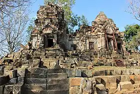
Wat Ek Phnom
Wat Ek Phnom (Khmer: វត្តឯកភ្នំ) is a partly collapsed 11th century temple 11 km north of Battambang city. The temple measures 52 m by 49 m and is surrounded by the remains of a laterite wall and an ancient baray (reservoir). A lintel depicting the Churning of the Ocean of Milk is above the east entrance to the central temple, the upper flanks of which hold some finely carved bas-reliefs. Construction of an oversized Buddha statue began by locals next to the temple has been stopped by the government because, they say, it mars the site’s historical provenance and "timeless beauty".[3]
Wat Banan
Wat Banan (Khmer: ភ្នំបាណន់), some 25 km south of Battambang city, has been likened to a smaller version of the more imposing Angkor Wat. The 11th century Angkorian mountain ruin of Phnom Banan is one of the best preserved Angkorian Khmer temples around Battambang province. As you approach you will see the distance five tower pointing skyward, Like a small version of Angkor Wat. At the base of the mountain you can faced with a step laterite staircase flanked by nagas. After climbing the 350+ steps you are treated to a wonderfully peaceful setting.
Transportation
Battambang is accessible by road, and by boat via the Sangkae River. National Highway 5 runs straight through the province. Both the airport and railway line are not in use. Buses make 5-6 hour journey from Phnom Penh and the 3-4 hour journey from Siem Reap almost hourly.
References
- "General Population Census of the Kingdom of Cambodia 2019 – Final Results" (PDF). National Institute of Statistics. Ministry of Planning. 26 January 2021. Retrieved 3 February 2021.
- "tsbr-ed.org". www.tsbr-ed.org. Archived from the original on 5 September 2008. Retrieved 7 April 2018.
- Wat Ek Phnom at Lonely Planet Archived March 15, 2010, at the Wayback Machine
External links
- Battambang - The Rice Bowl of Cambodia (Official Website of the Provincial Town Battambang on www.battambang-town.gov.kh) (in Khmer and English)
- Battambang Provincial Resources
Places adjacent to Battambang Province | |
|---|---|
| Autonomous municipality | ||
|---|---|---|
| Provinces | ||
| Authority control |
|---|