Kampong Thom Province
Kampong Thom (Khmer: ខេត្តកំពង់ធំ, IPA: [kɑmpɔːŋ tʰom], 'Great Port') is a province (khaet) of Cambodia. It borders the provinces of Siem Reap to the northwest, Preah Vihear to the north, Stung Treng to the northeast, Kratie to the east, Kampong Cham, Kampong Chhnang to the south, and the Tonle Sap to the west.
Kampong Thom
ខេត្តកំពង់ធំ | |
|---|---|
| Kampong Thom Province | |
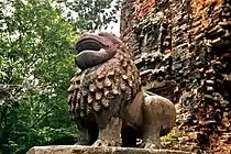
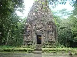 Sambor Prei Kuk, a UNESCO World Heritage Site and the symbol of the province | |
 Seal | |
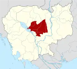 Map of Cambodia highlighting Kampong Thom | |
| Coordinates: 12°42′N 104°53′E | |
| Country | |
| Provincial status | 1907 |
| Capital | Steung Saen Municipality |
| Government | |
| • Governor | លោក សុខ លូ (Sok Lou) (CPP) |
| • National Assembly | 6 / 125
|
| Area | |
| • Total | 13,814 km2 (5,334 sq mi) |
| Area rank | 2nd |
| Population (2019)[1] | |
| • Total | |
| • Rank | 11th |
| • Density | 49/km2 (130/sq mi) |
| • Density rank | 17th |
| Time zone | UTC+7 (ICT) |
| Dialing code | +855 |
| ISO 3166 code | KH-6 |
| Districts | 8 |
| Website | www |
The provincial capital is Stung Saen, a town of approximately 30,000 people on the banks of the Stung Sen River.
Kampong Thom is Cambodia's second largest province by area. There are a number of significant Angkorian sites in the area, including Prasat Sambor Prei Kuk and Prasat Andet temples. As one of the nine provinces bordering Tonle Sap Lake, Kampong Thom is part of the Tonlé Sap Biosphere Reserve.[2]
Etymology
Kampong Thom in Khmer means 'great port' or 'great harbor'. Kampong in Khmer translates as 'port' or 'harbor'. The word Kampong is shared in other Austrasiatic languages, the Malay and Indonesian, both meaning 'village'. Thom in the Khmer language means 'big', 'grand', or 'large'.
Administration
The province is divided into seven districts and one municipality.
| ISO Code | District | Khmer |
|---|---|---|
| 06-01 | Baray | ស្រុកបារាយណ៍ |
| 06-02 | Kampong Svay | ស្រុកកំពង់ស្វាយ |
| 06-03 | Steung Saen Municipality | ក្រុងស្ទឹងសែន |
| 06-04 | Prasat Balangk | ស្រុកប្រាសាទបល្ល័ង្ក |
| 06-05 | Prasat Sambour | ស្រុកប្រាសាទសំបូរ |
| 06-06 | Sandaan | ស្រុកសណ្ដាន់ |
| 06-07 | Santuk | ស្រុកសន្ទុក |
| 06-08 | Stoung | ស្រុកស្ទោង |
History
The previous name of the province was Kampong Pous Thom ('Port', 'City of the Great Snakes'). According to local legend, at a lakeside dock near the Sen River, a pair of large snakes inhabited a nearby cave. On every Buddhist holiday, the snakes would make appearances to the people nearby who then began to refer to the area as Kampong Pous Thom. Eventually the snakes disappeared and the name was shortened to Kampong Thom. During the Colonial Cambodia period, the French divided Cambodian territory into provinces and named most of them according to the local popular names for the respective areas.
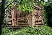
Kampong Thom was a powerful capital in Southeast Asia during the Funan period. Prasat Sambor Prei Kuk, dating from the Chenla Era, is in Kampong Thom Province.[3]
.jpg.webp)
Geography
Two of the three core areas in Tonlé Sap Biosphere Reserve lie in Kampong Thom.
- Boeng Chhmar (14,560 hectares), and
- Stung Saen (6,355 hectares).[4]
.jpg.webp)
Economy
Much of Kampong Thom is on the floodplain of the Tonlé Sap lake. In 2003–2004, it was a significant producer of wild fish (18,800 tons) and the fourth largest producer of fish through aquaculture in Cambodia (1,800 tons). Most of the fish-raising is done by home production, with a growing segment devoted to rice field aquaculture.[5]
Kampong Thom is also one of the largest producers of cashew nuts in Cambodia, with 6,371 hectares under production in 2003–2004.[6]
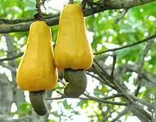 The province is one of the largest producer of cashews in the country. |
 Rice paddies in Baray District. |
.jpg.webp) Irrigation canals and farmlands |
Notable people
- Eng Chhai Eang, politician
- Kang Kek Iew, former Khmer Rouge personnel
- Ke Pauk, former Khmer Rouge personnel
- Kouch Sokumpheak, footballer
- Nguon Nhel, politician
- Pol Pot, former Khmer Rouge dictator and Prime Minister
Attraction
 Tonle Sap See
- Sambor Prei Kuk
 Phnom Santuk
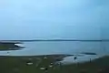 Prey Pras
References
- "General Population Census of the Kingdom of Cambodia 2019 – Final Results" (PDF). National Institute of Statistics. Ministry of Planning. 26 January 2021. Retrieved 3 February 2021.
- "Archived copy". Archived from the original on 5 September 2008. Retrieved 12 February 2020.CS1 maint: archived copy as title (link)
- Kubo, Sumiko; Shimamoto, Sae; Nagumo, Naoko; Yamagata, Mariko; Him, Sophorn; So, Sokuntheary; Chang, Vitharong; Lun, Votey; Shimoda, Ichita; Nakagawa, Takeshi (March 2012). "Geomorphology, Archaeo-stratigraphy, and 14C Ages of Sambor Prei Kuk Pre-Angkorean Site, Central Cambodia" (PDF). BULLETIN of the Graduate School of Education of Waseda University. 22. Archived from the original (PDF) on 22 December 2015. Retrieved 22 December 2015.
- Save Cambodia's Wildlife. The Atlas of Cambodia: National Poverty & Environment Maps, SWC, Phnom Penh, Cambodia, 2006, p. 72.
- Save Cambodia's Wildlife. The Atlas of Cambodia: National Poverty & Environment Maps, SWC, Phnom Penh, Cambodia, 2006, pp. 78–81.
- Ministry of Agriculture, Forestry & Fisheries, The Fruit Crops: Agricultural Statistics, 2003–04, Phnom Penh, 2004.
External links
| Wikimedia Commons has media related to Kampong Thom Province. |
Places adjacent to Kampong Thom Province | ||||||||||
|---|---|---|---|---|---|---|---|---|---|---|
| ||||||||||
Capital: Kampong Thom / Stueng Saen | ||
| Districts | | |
| Autonomous municipality | ||
|---|---|---|
| Provinces | ||