Bayfield, Ontario
Bayfield is a community in the municipality of Bluewater, Huron County in southwestern Ontario, Canada[1][2][3][4][5] with a 2016 population of 1,112.[6] It is on the eastern shore of Lake Huron at the mouth of Bayfield River.[4][5] Bayfield is a popular tourist destination. Visitors enjoy the historic Main Street with its many well-preserved old buildings,[7] including the Little Inn which has served travelers since the 1800s, initially as a stagecoach stop.[8] Main Street is lined with boutique shops, art galleries and fine dining restaurants. The nearby marina and public beaches draw crowds in the summer months.
Bayfield | |
|---|---|
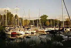 Marina in Bayfield | |
 Bayfield Location in southern Ontario | |
| Coordinates: 43°33′36″N 81°41′57″W[1] | |
| Country | Canada |
| Province | Ontario |
| County | Huron County |
| Municipality | Bluewater |
| Founded | 1832 |
| Founded by | Carel Lodewijk |
| Time zone | UTC-5 (Eastern Time Zone) |
| • Summer (DST) | UTC-4 (Eastern Time Zone) |
| Area codes | 519, 226, 548 |
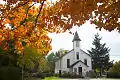
History
.jpg.webp)
Bayfield was founded in 1832 by Carel Lodewijk, Baron van Tuyll van Serooskerken (1784-1835), a Dutch nobleman who had purchased 388 acres (157 ha) in the area, part of a much larger holding in the Huron Tract that he purchased from the Canada Company[9][10] Over the next 10 years, a plan was laid out for the community and two mills (grist and lumber) were built. It was named for noted Great Lakes surveyor and British naval officer Admiral Henry Wolsey Bayfield, who had personally selected the site for the community.[11]
The mouth of the Bayfield River is a natural sheltered harbour[9] and by 1869, the settlement was a port of entry and vessels touched here on their route from Detroit to Goderich. Stages travelled daily to Seaforth.[12] In 1869, when the population was only 125, the settlement had a wagon and plough making shop, two blacksmiths, a distiller, a brickyard and two tanneries. A large, permanent harbour was built during the 1870s.[9] By 1876, Bayfield was incorporated as a village, with a population of 846.[9][13]
The Town Hall was built in 1882 and was not moved to its present location on Clan Gregor Square until 1920. By then, Bayfield had been in decline for at least 20 years, because the railway was built far from this area.[7] By 1984, it was closed as a fire hazard; fund raising allowed for repairs, and the hall was re-opened in 1993. After the Village became part of Bluewater in 2001, the Bayfield Town Hall was used for community events. Additional upgrades to the building were made in 2013 and 2016.[9]
Geography
Climate
| Climate data for Bayfield, Ontario | |||||||||||||
|---|---|---|---|---|---|---|---|---|---|---|---|---|---|
| Month | Jan | Feb | Mar | Apr | May | Jun | Jul | Aug | Sep | Oct | Nov | Dec | Year |
| Record high °C (°F) | 11.9 (53.4) |
18.5 (65.3) |
23.6 (74.5) |
23.9 (75.0) |
29.8 (85.6) |
32.0 (89.6) |
32.0 (89.6) |
34.4 (93.9) |
30.4 (86.7) |
25.5 (77.9) |
19.9 (67.8) |
16.7 (62.1) |
34.4 (93.9) |
| Average high °C (°F) | −0.7 (30.7) |
2.5 (36.5) |
5.2 (41.4) |
11.0 (51.8) |
18.0 (64.4) |
22.7 (72.9) |
24.1 (75.4) |
23.6 (74.5) |
21.0 (69.8) |
14.2 (57.6) |
7.5 (45.5) |
1.4 (34.5) |
12.5 (54.6) |
| Average low °C (°F) | −7.3 (18.9) |
−4.7 (23.5) |
−2.6 (27.3) |
1.4 (34.5) |
7.4 (45.3) |
12.6 (54.7) |
14.3 (57.7) |
13.4 (56.1) |
10.7 (51.3) |
5.2 (41.4) |
1.2 (34.2) |
−4.6 (23.7) |
3.9 (39.1) |
| Record low °C (°F) | −24.2 (−11.6) |
−17.6 (0.3) |
−21.8 (−7.2) |
−6.4 (20.5) |
−1.0 (30.2) |
3.8 (38.8) |
6.9 (44.4) |
5.2 (41.4) |
0.7 (33.3) |
−2.7 (27.1) |
−14.6 (5.7) |
−16.5 (2.3) |
−24.2 (−11.6) |
| Source: Environment Canada, The Weather Network | |||||||||||||
Arts and culture
As a small community Bayfield has many yearly traditions which include the Bayfield Fair in August, and Christmas in Bayfield, which takes place the weekend after Remembrance Day and includes the lighting of the trees in Clan Gregor Square as well as an annual Christmas Parade. Other annual events include the Fireman's Breakfast, Pioneer Park 5k Run, Santa Run, Halloween Witches Walk, and Corvette Fest and Volks Fest.
Bayfield has the largest croquet club in North America and members compete internationally.
Infrastructure
Gallery
 Bayfield's Town Hall
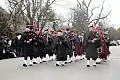 Bayfield Christmas Parade
 Bayfield's Main Beach
References
- "Bayfield". Geographical Names Data Base. Natural Resources Canada. Retrieved 2020-05-31.
- "Toporama (on-line map and search)". Atlas of Canada. Natural Resources Canada. Retrieved 2020-05-31.
- Restructured municipalities - Ontario map #6 (Map). Restructuring Maps of Ontario. Ontario Ministry of Municipal Affairs and Housing. 2006. Retrieved 2020-05-31.
- "Ontario Geonames GIS (on-line map and search)". Ontario Ministry of Natural Resources and Forestry. 2014. Retrieved 2020-05-31.
- Map 2 (PDF) (Map). 1 : 700,000. Official road map of Ontario. Ministry of Transportation of Ontario. 2018-01-01. Retrieved 2020-05-31.
- Census Profile, 2016, Statistics Canada
- Ron Brown (2016). Backroads of Ontario (4th ed.). Firefly Books. p. 49. ISBN 978-1770857070.
- Little Inn Retrieved 3 July 2018.
- History of Bayfield, Ontario Archived 2017-06-02 at the Wayback Machine Retrieved 3 July 2018.
- "The founding of Bayfield". Retrieved 3 July 2018.
- Rayburn, Alan (1997), Place Names of Ontario (University of Toronto Press), Toronto-Buffalo-London, ISBN 0-8020-7207-0), pg.25.
- The province of Ontario gazetteer and directory. H. McEvoy Editor and Compiler, Toronto : Robertson & Cook, Publishers, 1869.
- Ontario (1876). Statutes of the Province of Ontario. p. 165.
External links
| Wikimedia Commons has media related to Bayfield, Ontario. |
- Bayfield Chamber of Commerce website