Ashfield–Colborne–Wawanosh
The Township of Ashfield-Colborne-Wawanosh is a municipality in Huron County, Ontario, Canada. It was formed as an amalgamation of the former Ashfield, Colborne and West Wawanosh townships in 2001, in an Ontario-wide local government restructuring imposed by the government of that time. The three former townships now comprise the wards of the amalgamated municipality.
Ashfield-Colborne-Wawanosh | |
|---|---|
| Township of Ashfield-Colborne-Wawanosh | |
 | |
 Ashfield-Colborne-Wawanosh | |
| Coordinates: 43°52′N 81°36′W | |
| Country | Canada |
| Province | Ontario |
| County | Huron |
| Formed | 2001 |
| Government | |
| • Reeve | Glen McNeil |
| • Federal riding | Huron—Bruce |
| • Prov. riding | Huron—Bruce |
| Area | |
| • Land | 587.08 km2 (226.67 sq mi) |
| Elevation | 269 m (883 ft) |
| Population (2016)[2] | |
| • Total | 5,422 |
| • Density | 9.2/km2 (24/sq mi) |
| Time zone | UTC−05:00 (EST) |
| • Summer (DST) | UTC−04:00 (EDT) |
| Area code(s) | 519 and 226 |
| Website | www |
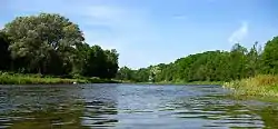
Geography
Ashfield–Colborne–Wawanosh is located in the northwest corner of Huron County. Lake Huron is the western boundary and the Township has 35.3 km (21.9 mi) of Lake Huron shoreline. Its southern boundary is the Maitland River between Goderich and Auburn. The eastern border is Huron Road 22, from Auburn north to Huron Road 86 near Whitechurch. Huron Road 86 is generally the northern border of Ashfield–Colborne–Wawanosh except for the Lucknow community limits which are in Bruce County.[3]
Communities
The township encompasses the communities of Amberley, Auburn, Benmiller, Carlow, Dungannon, Kingsbridge, Kintail, Nile, Port Albert, St. Augustine, St. Helens and Saltford.
Military history
.jpg.webp)
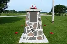
During World War II the Royal Air Force operated No. 31 Air Navigation School as part of the British Commonwealth Air Training Plan on Highway 21 near Port Albert. The school relocated from Great Britain to RCAF Station Port Albert on 18 November 1940 and closed on 17 February 1945.[4]
The 402 acres (163 ha) site was later used as a race car track and in 2013 is farmland.
There is a memorial cairn and plaque at 83700 Highway 21. The airfield was located across the road from the cairn at 43°53′5″N 081°41′48″W .[5] The Huron Country Museum in nearby Goderich, Ontario has an extensive collection of artifacts from No. 31 ANS.
Transportation
Highway 21 travels through the western portion of the township.
Huron Road 1 proceeds north from Benmiller through Carlow then Lucknow.
Goderich Municipal Airport is also located in the Township of ACW.
Facilities
Municipal offices are located west of Carlow (82133 Council Line), north-east of Goderich at the south end of the township.
Demographics
| Canada census – Ashfield-Colborne-Wawanosh, Ontario community profile | |||
|---|---|---|---|
| 2016 | 2011 | 2006 | |
| Population: | 5,422 (-2.9% from 2011) | 5,582 (+3.2% from 2006) | 5,409 (0.0% from 2001) |
| Land area: | 586.97 km2 (226.63 sq mi) | 587.08 km2 (226.67 sq mi) | 587.07 km2 (226.67 sq mi) |
| Population density: | 9.2/km2 (24/sq mi) | 9.5/km2 (25/sq mi) | 9.2/km2 (24/sq mi) |
| Median age: | 47.7 (M: 47.7, F: 47.8) | 45.3 (M: 45.3, F: 45.3) | 42.0 (M: 42.2, F: 41.9) |
| Total private dwellings: | 2,105 | 3,034 | 2,920 |
| Median household income: | $70,496 | $50,350 | |
| References: 2016[6] 2011[1] 2006[7] earlier[8] | |||
| Year | Pop. | ±% |
|---|---|---|
| 1996 | 5,477 | — |
| 2001 | 5,411 | −1.2% |
| 2006 | 5,409 | −0.0% |
| 2011 | 5,582 | +3.2% |
| 2016 | 5,422 | −2.9% |
| [9][1][2] | ||
Populations prior to amalgamation (2001):
- Population total in 1996: 5,477
- Ashfield (township): 1,885
- Colborne (township): 2,182
- West Wawanosh (township): 1,410
- Population in 1991:
- Ashfield (township): 1,809
- Colborne (township): 2,043
- West Wawanosh (township): 1,389
References
- "2011 Community Profiles". 2011 Canadian Census. Statistics Canada. July 5, 2013. Retrieved 2012-08-10.
- "Census Profile, 2016 Census Ashfield-Colborne-Wawanosh, Township". Statistics Canada. Retrieved April 30, 2019.
- "Municipalities / Townships of Huron County" (PDF). Huron County. August 2003. Archived from the original (PDF) on 2010-10-11. Retrieved 2010-06-24.
- Hatch, F. J. (1983). The Aerodrome of Democracy: Canada and the British Commonwealth Air Training Plan, 1939-1945. Ottawa: Directorate of History, Department of National Defence. ISBN 0660114437.
- Anon (2009). "Abandoned Aerodromes". Canada Flight Supplement Effective 0901Z 12 March 2009 To 0901Z 7 May 2009. Ottawa: Nav Canada. p. A35.
- "2016 Community Profiles". 2016 Canadian Census. Statistics Canada. February 21, 2017. Retrieved April 30, 2019.
- "2006 Community Profiles". 2006 Canadian Census. Statistics Canada. March 30, 2011. Retrieved 2009-02-24.
- "2001 Community Profiles". 2001 Canadian Census. Statistics Canada. February 17, 2012.
- Statistics Canada: 1996, 2001, 2006 census
- "Ashfield-Colborne-Wawanosh". Geographical Names Data Base. Natural Resources Canada. Retrieved 2010-06-24.
- "Toporama - Topographic Map Sheet3 40P12, 40P13, 40P14, 41A4". Atlas of Canada. Natural Resources Canada. Archived from the original on 2010-08-31. Retrieved 2010-06-24.
- McGee, Eugene (1986). History of Port Albert. Port Albert, Ontario: E. McGee.
External links
| Wikimedia Commons has media related to Ashfield–Colborne–Wawanosh. |
Places adjacent to Ashfield–Colborne–Wawanosh | ||||||||||
|---|---|---|---|---|---|---|---|---|---|---|
| ||||||||||