Huron County, Ontario
Huron County is a county of the province of Ontario, Canada. It is located on the southeast shore of its namesake, Lake Huron, in the southwest part of the province. The county seat is Goderich, also the county's largest community.
Huron County | |
|---|---|
| County of Huron | |
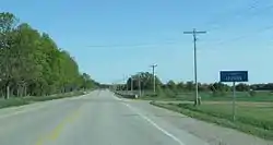 Entering Huron County on Highway 21 | |
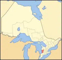 Huron County's location in relation to Ontario | |
| Coordinates: 43°40′N 81°24′W | |
| Country | |
| Province | |
| County seat | Goderich |
| Municipalities | |
| Area | |
| • Land | 3,399.27 km2 (1,312.47 sq mi) |
| Population (2016)[1] | |
| • Total | 59,297 |
| • Density | 17.4/km2 (45/sq mi) |
| Time zone | UTC-5 (EST) |
| • Summer (DST) | UTC-4 (EDT) |
| Postal code span | N0G, N0M, N7A |
| Website | www |
The population reported in the 2016 Census for this predominantly agricultural area with many villages and small towns was 59,297 in a land area of 3,399 square kilometres.[1] Of the total population, 7,628 reside in Goderich.
History
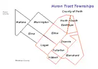
 Original extent of the Huron Tract.
_-_Geographicus_-_WestCanada-tallis-1850.jpg.webp) Map of Canada West in 1850, with the Huron District outlined in brown.
Map of Canada West in 1850, with the Huron District outlined in brown.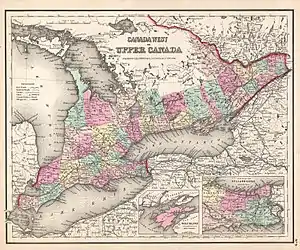 Canada West in 1857. Huron County is marked in light pink.
The portion of the Huron Tract ceded to the Canada Company was established as the "County of Huron" in 1835, with the exception of certain townships that were transferred to other counties:[2]
- Adelaide Township went to Middlesex County
- The townships of Moore and Sarnia, Plympton, Enniskillen, Warwick, Brooke and Bosanquet went to Kent County
Historic townships
In 1835, the County was declared to consist of the following townships:[3]
- Biddulph
- Blanshard
- Colborne
- Downie
- Ellice
- South Easthope
- North Easthope
- Fullarton
- Goderich
- Hay
- Hibbert
- Hullett
- Logan
- McKillop
- McGillivray
- Stephen
- Stanley
- Tuckersmith
- Usborne
- Williams
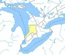
They have since devolved to the following counties (as outlined in red):
 Huron County
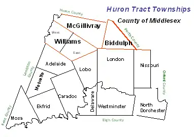
Territorial evolution
Legislation was passed by the Legislative Assembly of Upper Canada in 1838 to authorize the separation of the County from the London District and constitute it as the Huron District.[4] The County was extended northward in 1840, upon the survey of a new range of townships on its northern boundary, beginning with Ashfield Township, and later including Wawanosh, Morris, Grey and Elma.[5] The District itself came into being in October 1841.[6]
Huron County was continued for electoral purposes in 1845,[7] and the District was extended northwards as far as the Bruce Peninsula in 1846.[8]
The District (which existed for judicial and municipal purposes) was abolished at the beginning of 1850.[9] Legislation passed later in the same session of the Legislative Assembly of the Province of Canada provided for the County to be reconstituted as the United Counties of Huron, Perth and Bruce, with the territory of the Bruce Peninsula withdrawn and annexed to Waterloo County.[10] The townships were distributed as follows:
| From | Perth County | Bruce County | Huron County |
|---|---|---|---|
| Huron County |
|
|
|
| Waterloo County |
|
The Bruce Peninsula was later returned to Bruce in 1851.[12] The County of Perth was given its own Provisional Municipal Council at that time,[13] and was separated from the United Counties in 1853.[14]
Several townships were transferred to Middlesex County:
Legislation was passed in 1866 to provide for the dissolution of the United Counties on January 1, 1867, with Huron and Bruce County becoming separate counties for all purposes.[17]
Government
The Huron County Council consists of fifteen members from the nine area municipalities to ensure that each is represented on this Council. Each year, a Warden is elected from the group; this individual chairs meetings and represents the County at various functions. In 2017, the Reeve was Ben Van Diepenbeek from the Ashfield-Colborne-Wawanosh ward.[18]
Most of the population of the county resides in the Huron—Bruce, formerly Huron and Huron—Middlesex, federal electoral district. The majority also reside in the Huron—Bruce (provincial electoral district) formerly known as Huron and Huron—Middlesex.
The County's Official Plan (2015) addresses the following issues: "agriculture, community services, the economy, natural environment, extractive resources, and settlement patterns." According to this document, agriculture is a particularly significant part of the economy since "Huron leads all counties and regions in Ontario in total value of production; and it also exceeds the production totals of several provinces".[19]
Municipalities
Huron County comprises nine lower-tier municipalities (in order of population):
- Municipality of South Huron (population centre: Exeter)
- Municipality of Huron East (population centres: Seaforth, Brussels)
- Town of Goderich
- Municipality of Central Huron (population centre: Clinton)
- Municipality of Bluewater (population centre: Bayfield)
- Township of Ashfield–Colborne–Wawanosh
- Township of North Huron (population centre: Wingham)
- Municipality of Howick
- Municipality of Morris-Turnberry
The boundaries of the county's municipalities have been in effect since 2001, after the provincial government imposed mergers throughout the province.
Demographics
Huron County comprises a single Statistics Canada census division. The population has been quite stable in recent years.
| Canada census – Huron County, Ontario community profile | |||
|---|---|---|---|
| 2016 | 2011 | 2006 | |
| Population: | 59,297 (0.3% from 2011) | 59,100 (-0.4% from 2006) | 59,325 (-0.6% from 2001) |
| Land area: | 3,399.27 km2 (1,312.47 sq mi) | 3,399.63 km2 (1,312.60 sq mi) | 3,396.68 km2 (1,311.47 sq mi) |
| Population density: | 17.4/km2 (45/sq mi) | 17.4/km2 (45/sq mi) | 17.5/km2 (45/sq mi) |
| Median age: | 46.3 (M: 45.3, F: 47.4) | 45.1 (M: 44, F: 46) | 42.3 (M: 41.5, F: 43.1) |
| Total private dwellings: | 28,369 | 28,049 | 26,922 |
| Median household income: | $65,944 | $51,910 | |
| References: 2016[20] 2011[21] 2006[22] earlier[23] | |||
Historic populations:[23]
- Population in 2001: 59,701
- Population in 1996: 60,220
| Group | 2016 Census | 2011 Census | 2006 Census | ||||
|---|---|---|---|---|---|---|---|
| Population | % of total | Population | % of Total | Population | % of Total | ||
| Canadian citizen | By birth | 53,510 | 92.5 | No data | 53,690 | 91.6 | |
| By naturalization | 3,400 | 5.9 | 3,980 | 6.8 | |||
| Permanent resident | 795 | 1.4 | 685 | 1.2 | |||
| Non-permanent resident | 125 | 0.2 | 235 | 0.4 | |||
| Total | 57,830 | 100.0 | 58,595 | 100.0 | |||
| Group | 2016 Census | 2011 Census | 2006 Census | 2001 Census | ||||
|---|---|---|---|---|---|---|---|---|
| Population | % of total | Population | % of Total | Population | % of Total | Population | % of Total | |
| Aboriginal | 810 | 1.4 | No data | 320 | 0.5 | 255 | 0.4 | |
| Visible Minority | 865 | 1.5 | 875 | 1.5 | 690 | 1.2 | ||
| All other | 56,155 | 97.1 | 57,395 | 98.0 | 57,750 | 98.4 | ||
| Total | 57,830 | 100.0 | 58,590 | 100.0 | 58,695 | 100.0 | ||
| Group | 2016 Census | 2011 Census | 2006 Census | 2001 Census | ||||
|---|---|---|---|---|---|---|---|---|
| Population | % of total | Population | % of Total | Population | % of Total | Population | % of Total | |
| English | 53,020 | 90.9 | 53,075 | 90.9 | 53,375 | 91.1 | 53,445 | 91.1 |
| French | 370 | 0.6 | 460 | 0.8 | 385 | 0.7 | 395 | 0.7 |
| English and French | 60 | 0.1 | 55 | 0.1 | 85 | 0.1 | 75 | 0.1 |
| All other | 4,905 | 8.4 | 4,795 | 8.2 | 4,745 | 8.1 | 4,780 | 8.1 |
| Total | 58,355 | 100.0 | 58,385 | 100.0 | 58,590 | 100.0 | 58,695 | 100.0 |
(Other languages, 2016: German 3.3%, Dutch 2.1%)
| Group | 2016 Census | 2011 Census | 2006 Census | 2001 Census | ||||
|---|---|---|---|---|---|---|---|---|
| Population | % of total | Population | % of Total | Population | % of Total | Population | % of Total | |
| At the same address | 38,840 | 71.3 | No data | 38,520 | 69.4 | 37,835 | 68.4 | |
| In the same municipality | 6,255 | 11.5 | 7,190 | 12.9 | 16,315 | 29.5 | ||
| In the same province | 8,590 | 15.8 | 8,825 | 15.9 | ||||
| From another province | 375 | 0.7 | 480 | 0.9 | 1,150 | 2.1 | ||
| From another country | 395 | 0.7 | 485 | 0.9 | ||||
| Total aged 5 or over | 54,455 | 100.0 | 55,505 | 100.0 | 55,300 | 100.0 | ||
Communities
- Amberley (border with Bruce County)
- Auburn
- Bayfield
- Belgrave
- Belmore (border with Bruce County)
- Benmiller
- Bluevale
- Blyth
- Brucefield
- Brussels
- Carlow
- Centralia (border with Middlesex County)
- Clinton
- Corbett (border with Middlesex County)
- Crediton
- Dashwood
- Drysdale
- Dungannon
- Egmondville
- Ethel
- Exeter
- Fordwich
- Goderich
- Gorrie
- Harpurhey
- Hensall
- Holmesville
- Huron Park
- Kinburn
- Kingsbridge
- Kintail
- Kippen
- Kirkton (border with Perth County)
- Lakelet
- Leadbury
- Londesborough
- Molesworth (border with Perth County)
- Mount Carmel (border with Middlesex County)
- Nile
- Port Albert
- St. Augustine
- St. Columban (border with Perth County)
- St. Joseph
- Saltford
- Seaforth
- Shipka
- Summerhill
- Sunshine
- Vanastra
- Varna
- Walton
- Whitechurch (border with Bruce County)
- Wingham
- Winthrop
- Whalen Corners (border with Perth and Middlesex Counties)
- Woodham (border with Perth County)
- Wroxeter
- Zurich
Former communities/ghost towns
- Donnybrook
- Francistown
- Mafeking
- McGaw
- Rodgerville
- Sodom
- Spidertown (border with Middlesex County)
See also
References
- "Census Profile, 2016 Census - Huron County, Ontario". StatsCan. StatsCan. 2016. Retrieved 9 March 2017.
- An Act to form certain Townships in the London District into a County, and to attach certain Townships to the Counties of Middlesex and Kent, in the London and Western Districts, S.U.C. 1835, c. 45
- 1835 Act, s. 1
- An Act to authorize the erection of the County of Huron, and certain other territory adjacent thereto, into a separate District, S.U.C. 1838, c. 26
- An Act to attach certain Townships to the County of Huron, S.U.C. 1840, c. 38
- "Proclamation". Canada Gazette. 1 (3 (Extra)): 30. October 21, 1841.
- An Act for better defining the limits of the Counties and Districts in Upper Canada, for erecting certain new Townships, for detaching Townships from some Counties and attaching them to others, and for other purposes relative to the division of Upper Canada into Townships, Counties and Districts, S.Prov.C. 1845, c. 7, s. 8
- An Act to attach certain Territory therein described to the District of Huron for certain purposes, S.Prov.C. 1846, c. 47
- An Act for abolishing the Territorial Division of Upper-Canada into Districts, and for providing temporary Unions of Counties for Judicial and other purposes, and for the future dissolutions of such Unions, as the increase of wealth and population may require, S.Prov.C. 1849, c. 78, Sch. C
- An Act to divide the District of Huron, in the Province of Canada, and for other purposes therein mentioned, S.Prov.C. 1849, c. 96
- 1849 Act, ss. 33, 35, 36
- An Act to make certain alterations in the Territorial Divisions of Upper Canada, S.Prov.C. 1851, c. 5, Sch. A, par. 29
- S.Prov.C. 1849, c. 96, s. 3
- An Act to authorize to Governor General to issue a Proclamation to declare the County of Perth to be separated from the United Counties of Huron, Perth and Bruce, and for other purposes therein mentioned, S.Prov.C. 1852, c. 31
- 1845 Act, Sch. B
- An Act to separate the Townships of Biddulph and McGillivray from the County of Huron, and to annex the same to the East Riding of the County of Middlesex, S.Prov.C. 1862, c. 28
- "Proclamation". Canada Gazette. 25 (48): 4606. December 1, 1866., implementing An Act to facilitate the separation of Huron and Bruce, and to appoint Walkerton the County Town of the County of Bruce, S.Prov.C. 1865, c. 66
- "Council". Huron County. Huron County. 2017. Retrieved 9 March 2017.
- "Official Plan" (PDF). Huron County. Huron County. 2015. Retrieved 9 March 2017.
- "2016 Community Profiles". 2016 Canadian Census. Statistics Canada. February 21, 2017. Retrieved 2017-11-06.
- "2011 Community Profiles". 2011 Canadian Census. Statistics Canada. July 5, 2013. Retrieved 2012-03-26.
- "2006 Community Profiles". 2006 Canadian Census. Statistics Canada. March 30, 2011. Retrieved 2017-11-06.
- "2001 Community Profiles". 2001 Canadian Census. Statistics Canada. February 17, 2012.
External links
| Wikimedia Commons has media related to Huron County, Ontario. |
Places adjacent to Huron County, Ontario | |
|---|---|
| Regions | |
|---|---|
| Counties | |
| Districts | |
| Regional municipalities | |
| Single-tier municipalities | |
| Separated municipalities | |
| |