Beerwah, Queensland
Beerwah (/ˈbɪərwɑː, -wɔː/) is a rural town and a locality in the hinterland of the Sunshine Coast Region, Queensland, Australia.[2][3] Australia Zoo located here is a major tourist attraction and is visited daily by large numbers of local, national and international tourists. Beerwah has transport links to Brisbane and northbound destinations at Beerwah railway station on the Nambour and Gympie North railway line. Roads in the area include a bypass in the south of the town, Kilcoy-Beerwah Road and Steve Irwin Way.
| Beerwah Sunshine Coast, Queensland | |||||||||||||||
|---|---|---|---|---|---|---|---|---|---|---|---|---|---|---|---|
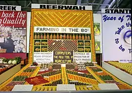 Beerwah fruit and vegetable display, RNA Exhibition, Brisbane, August 1984 | |||||||||||||||
 Beerwah | |||||||||||||||
| Coordinates | 26°51′20″S 152°57′36″E | ||||||||||||||
| Population | 6,769 (2016 census)[1] | ||||||||||||||
| • Density | 116.51/km2 (301.75/sq mi) | ||||||||||||||
| Postcode(s) | 4519 | ||||||||||||||
| Area | 58.1 km2 (22.4 sq mi) | ||||||||||||||
| Location |
| ||||||||||||||
| LGA(s) | Sunshine Coast Region | ||||||||||||||
| County | Canning | ||||||||||||||
| Parish | Bribie | ||||||||||||||
| State electorate(s) | Caloundra, Glass House | ||||||||||||||
| Federal Division(s) | Fisher | ||||||||||||||
| |||||||||||||||
Geography
Beerwah is situated north of Glass House Mountains, approximately 80 kilometres (50 mi) north of Brisbane, and just south of Landsborough. The main road through Beerwah is called Steve Irwin Way.[4] It was formerly known as the Glasshouse Mountain Tourist Route and is accessed by the Bruce Highway, which bypassed the town in 1985.
History
The name Beerwah comes from the Kabi language (Turrbal dialect) word birrawaman, with birra meaning sky and wandum meaning climbing up.[2][3]
Beerwah Post Office opened by August 1907 (a receiving office had been open from 1891).[5]
The Coochin Creek Provisional School opened in November 1888, becoming Coochin Creek State School on 1 January 1909. In about November 1928, it was renamed Beerwah State School. On 10 July 1952, another Coochin Creek State School opened, but it closed on 11 March 1962.[6][7]
On Saturday 26 September 1914 the local Anglican residents held a meeting to consider erecting a church in Beerwah. Mr Mawhinney donated a piece of land by the raiilway station.[8] On Saturday 7 November 1914 Archdeacon Henry Le Fanu officially capped the first stump of the new church building. All the materials for the church and the labour were all donated so the church would be free of debt.[9] On Saturday 6 March 1916 Archdeacon Le Fanu returned to officially open and dedicate St James' Anglican Church.[10] In the 1990s diminishing numbers in the congregations led to a decision to close a number of churches in the area. St James' was closed and sold for removal.[11]
On 4 July 1991 the Mary MacKillop Catholic Centre was blessed and opened by Archbishop Francis Rush.[12]
Beerwah State High School opened on 1 January 1992.[13]
The Beerwah Library opened in 2000.[14]
Heritage listings
Beerwah has a number of heritage-listed sites, including:
- 53 Beerwah Parade: Beerwah Hotel[15]
- 2719 Old Gympie Road: Site of Coochin Homestead[16]
- Roys Road and Mawsons Road (Beerburrum State Forest): Beerburrum Scientific Area No 1[17]
- Roys Road, approximately 1 km east of Mawsons Road intersection: former Beerwah Forest Station and Arboretum[18]
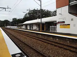
- Simpson Street: Beerwah railway station[19]
Transport
Beerwah is a growing hinterland town.[20] Transport links to Brisbane and northbound destinations at Beerwah railway station on the Nambour and Gympie North railway line.
A small bypass was constructed south of the town, including an overpass of the railway, a large roundabout at Roberts Road, and traffic signals at Kilcoy-Beerwah Road and Steve Irwin Way. This work opened to traffic in October 2009. As part of that project, however, the original level crossing was closed and demolished, causing concern among local residents who claimed it sliced the town in two.[21] In 2010, many residents began to complain about the lack of signage to the town center. The town entrance now features two distinctive large directional signs, one at the Steve Irwin Way entrance, and one at the roundabout after travelling over the railway bridge.
Tourism
Australia Zoo is located in Beerwah. The zoo was founded by Bob Irwin and later made famous by his son, Steve Irwin. It is a major tourist attraction and is visited daily by large numbers of local, national and international tourists.
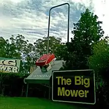
Another attraction, the Glass House mountain range, is located nearby. The largest mountain in the range, at 555m, is Mount Beerwah. Access to the Mount Beerwah summit route has been closed since 2008 due to the erosion and destabilization of some walking tracks, leading to a high risk of rock fall.[22] The Big Mower, one of Australia's big things, is located in Beerwah.
Education
Beerwah has three schools: Beerwah State School, Beerwah State High School, and Glasshouse Christian College, a private college.[23]
Amenities
The Sunshine Coast Regional Council operates a public library at 25 Peachester Road.[24]
There are a range of national supermarkets, specialty shops, and a retirement village.
The Beerwah branch of the Queensland Country Women's Association meets at 39 Simpson Street.[25]
Anglican church services are held at the Mary MacKillop Catholic Centre at 160 Peachester Road (26.8579°S 152.9427°E).[11][26][27]
Demographics
In the 2016 census, Beerwah recorded a population of 6,769 people, 52% female and 48% male.
The median age was 39 years, compared to the national median age of 38.
Aboriginal and Torres Strait Islander people made up 2.8% of the population.
77.2% of people were born in Australia. The next most common countries of birth were England 5.1% and New Zealand 4.8%.
90.8% of people only spoke English at home.
The most common responses for religion in Beerwah were No Religion 32.8%, Anglican 17.2% and Catholic 14.4%.[1]
Notable residents
See also
References
- Australian Bureau of Statistics (27 June 2017). "Beerwah (State Suburb)". 2016 Census QuickStats. Retrieved 29 January 2018.

- "Beerwah – suburb in Sunshine Coast Region (entry 2095)". Queensland Place Names. Queensland Government. Retrieved 28 September 2017.
- "Beerwah – locality in the Sunshine Coast Region (entry 48521)". Queensland Place Names. Queensland Government. Retrieved 28 September 2017.
- "Irwin our 'greatest cultural ambassador': Beattie". Brisbane Times. 4 September 2007. Archived from the original on 6 October 2012. Retrieved 20 November 2010.
- Premier Postal History. "Post Office List". Premier Postal Auctions. Archived from the original on 15 May 2014. Retrieved 10 May 2014.
- "Agency ID 4832, Beerwah State School". Queensland State Archives. Retrieved 15 April 2014.
- "Agency ID 4832, Coochin Creek State School". Queensland State Archives. Retrieved 15 April 2014.
- "BEERWAH". Chronicle And North Coast Advertiser. XI (581). Queensland, Australia. 2 October 1914. p. 2. Archived from the original on 25 September 2020. Retrieved 25 September 2020 – via National Library of Australia.
- "ANGLICAN ACTIVITY AT BEERWAH". The Telegraph (13, 100). Queensland, Australia. 14 November 1914. p. 9. Archived from the original on 25 September 2020. Retrieved 25 September 2020 – via National Library of Australia.
- "RELIGIOUS". The Brisbane Courier (17, 834). Queensland, Australia. 13 March 1915. p. 16. Archived from the original on 25 September 2020. Retrieved 25 September 2020 – via National Library of Australia.
- "Parish profile" (PDF). The Anglican Parish of Caloundra-Glasshouse Country. p. 3. Archived (PDF) from the original on 24 September 2020. Retrieved 25 September 2020.
- "Beerwah Catholic Church". Churches Australia. Archived from the original on 25 September 2020. Retrieved 25 September 2020.
- "Agency ID 5163, Beerwah State High School". Queensland State Archives. Retrieved 15 April 2014.
- "Public Libraries Statistical Bulletin 2016-17" (PDF). Public Libraries Connect. State Library of Queensland. November 2017. p. 15. Archived (PDF) from the original on 30 January 2018. Retrieved 30 January 2018.
- "Beerwah Hotel" (PDF). Sunshine Coast Region Heritage Register. Sunshine Coast Regional Council. Retrieved 20 April 2019.
- "Site of Coochin Homestead" (PDF). Sunshine Coast Region Heritage Register. Sunshine Coast Regional Council. Retrieved 20 April 2019.
- "Beerburrum Scientific Area No 1" (PDF). Sunshine Coast Region Heritage Register. Sunshine Coast Regional Council. Retrieved 20 April 2019.
- "Beerwah Forest Station and Arboretum (former)" (PDF). Sunshine Coast Region Heritage Register. Sunshine Coast Regional Council. Retrieved 20 April 2019.
- "Beerwah Railway Station" (PDF). Sunshine Coast Region Heritage Register. Sunshine Coast Regional Council. Retrieved 20 April 2019.
- Owen Jacques (11 November 2010). "Hinterland to get 300 new homes". Sunshine Coast Daily. APN News & Media Ltd. Archived from the original on 13 November 2010. Retrieved 20 November 2010.
- "Councillor calls on Government to keep Beerwah crossing". viewnews.com.au. View News & Media. 7 October 2009. Archived from the original on 6 October 2011. Retrieved 23 June 2011.
- "Mount Beerwah summit route—temporary closure". Queensland Government. Archived from the original on 4 September 2015. Retrieved 16 July 2015.
- "Beerwah Schools". Archived from the original on 20 February 2012. Retrieved 19 April 2018.
- "Beerwah Library". Sunshine Coast Regional Council. Archived from the original on 30 January 2018. Retrieved 30 January 2018.
- "Branch Locations". Queensland Country Women's Association. Archived from the original on 26 December 2018. Retrieved 26 December 2018.
- "Beerwah Anglican Church". Churches Australia. Archived from the original on 25 September 2020. Retrieved 25 September 2020.
- "Churches & Mass Centres". Caloundra Catholic Parish. Archived from the original on 25 September 2020. Retrieved 25 September 2020.
External links
| Wikimedia Commons has media related to Beerwah, Queensland. |