Wootha, Queensland
Wootha is a rural locality in the Sunshine Coast Region, Queensland, Australia.[2] In the 2016 census Wootha had a population of 201 people.[1]
| Wootha Queensland | |||||||||||||||
|---|---|---|---|---|---|---|---|---|---|---|---|---|---|---|---|
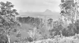 Looking across Wootha towards the Glass House Mountains, circa 1931 | |||||||||||||||
 Wootha | |||||||||||||||
| Coordinates | 26.7875°S 152.8002°E | ||||||||||||||
| Population | 201 (2016 census)[1] | ||||||||||||||
| • Density | 12.48/km2 (32.33/sq mi) | ||||||||||||||
| Postcode(s) | 4552 | ||||||||||||||
| Area | 16.1 km2 (6.2 sq mi) | ||||||||||||||
| Time zone | AEST (UTC+10:00) | ||||||||||||||
| LGA(s) | Sunshine Coast Region | ||||||||||||||
| State electorate(s) | Glass House | ||||||||||||||
| Federal Division(s) | Fisher | ||||||||||||||
| |||||||||||||||
History
The name Wootha comes from the Kabi language (Dallambara dialect) meaning red cedar tree.[2]
Blackall Range Provisional School opened about 1886, becoming Blackall Range State School on 1 October 1909. It was renamed Wootha State School in 1937. It closed in 1949.[3]
In the 2016 census Wootha had a population of 201 people.[1]
References
| Wikimedia Commons has media related to Wootha, Queensland. |
- Australian Bureau of Statistics (27 June 2017). "Wootha (SSC)". 2016 Census QuickStats. Retrieved 20 October 2018.

- "Wootha – locality in Sunshine Coast Region (entry 48944)". Queensland Place Names. Queensland Government. Retrieved 29 December 2020.
- Queensland Family History Society (2010), Queensland schools past and present (Version 1.01 ed.), Queensland Family History Society, ISBN 978-1-921171-26-0
This article is issued from Wikipedia. The text is licensed under Creative Commons - Attribution - Sharealike. Additional terms may apply for the media files.
