Maroochy River, Queensland
Maroochy River is a rural hinterland locality in the Sunshine Coast Region, Queensland, Australia.[2] In the 2016 census Maroochy River had a population of 1,531 people.[1]
| Maroochy River Queensland | |||||||||||||||
|---|---|---|---|---|---|---|---|---|---|---|---|---|---|---|---|
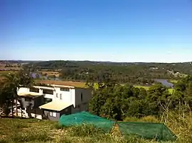 View from slopes of Mount Ninderry towards the Maroochy River, 2012 | |||||||||||||||
 Maroochy River | |||||||||||||||
| Coordinates | 26.5819°S 153.0177°E | ||||||||||||||
| Population | 1,531 (2016 census)[1] | ||||||||||||||
| • Density | 59.11/km2 (153.1/sq mi) | ||||||||||||||
| Postcode(s) | 4561 | ||||||||||||||
| Area | 25.9 km2 (10.0 sq mi) | ||||||||||||||
| Time zone | AEST (UTC+10:00) | ||||||||||||||
| Location | 113 km (70 mi) N of Brisbane | ||||||||||||||
| LGA(s) | Sunshine Coast Region | ||||||||||||||
| State electorate(s) | Ninderry | ||||||||||||||
| Federal Division(s) | Fairfax | ||||||||||||||
| |||||||||||||||
Geography
The Maroochy River meanders from west to east through the locality. The surrounding river flats are cleared and primarily used for farming. The hillsides in the north-west and south-east of the locality are primarily used for residential purposes and retain natural bushland. Coolum Creek forms the eastern boundary of the locality.[3]
History
The name Maroochy is either a Yugarabul name collected by Andrew Petrie when he explored Wide Bay in 1842 or from Kabi word muru-kutchi meaning red bill referring to the black swan.[2]
Maroochy River State School opened on 27 June 1911. It closed on 31 December 1972.[4]
In the 2011 census Maroochy River had a population of 1,337 people.[5]
In the 2016 census Maroochy River had a population of 1,531 people.[1]
Heritage listings
Maroochy River has a number of heritage-listed sites, including:
- Dunethin Rock Road: Dunethin Rock[6]
- Store Road: Tramway Lift Bridge over Maroochy River[7]
Amenities
There are a number of parks in the area, including:
- 2nd/14th Battalion Park (26.5551°S 152.9903°E)[8]
- Callicoma Place Natural Amenity Reserve (26.5881°S 153.0140°E)[8]
- Coolum Creek Environmental Reserve (17.7246°S 102.0755°E)[8]
- Coolum Creek North Conservation Area (17.7014°S 101.9841°E)[8]
- Dunethin Rock Bushland Reserve Network (17.7239°S 102.0086°E)[8]
- Dunethin Rock Recreation Area (26.5764°S 153.0105°E)[8]
- Maroochy River Esplanade - River Road (17.7146°S 102.0351°E)[8]
- Mount Ninderry Bushland Conservation Reserve (17.7055°S 102.0057°E)[8]
References
- Australian Bureau of Statistics (27 June 2017). "Maroochy River (SSC)". 2016 Census QuickStats. Retrieved 20 October 2018.

- "Maroochy River – locality in Sunshine Coast Region (entry 50289)". Queensland Place Names. Queensland Government. Retrieved 29 December 2020.
- "Queensland Globe". State of Queensland. Retrieved 25 July 2015.
- Queensland Family History Society (2010), Queensland schools past and present (Version 1.01 ed.), Queensland Family History Society, ISBN 978-1-921171-26-0
- Australian Bureau of Statistics (31 October 2012). "Maroochy River". 2011 Census QuickStats. Retrieved 25 July 2015.
- "Dunethin Rock (entry 602695)". Queensland Heritage Register. Queensland Heritage Council. Retrieved 14 July 2013.
- "Tramway Lift Bridge over Maroochy River (entry 602527)". Queensland Heritage Register. Queensland Heritage Council. Retrieved 14 July 2013.
- "Land for public recreation - Queensland". Queensland Open Data. Queensland Government. 20 November 2020. Archived from the original on 22 November 2020. Retrieved 22 November 2020.
External links
![]() Media related to Maroochy River, Queensland at Wikimedia Commons
Media related to Maroochy River, Queensland at Wikimedia Commons