Belovsky District, Kemerovo Oblast
Belovsky District (Russian: Бело́вский райо́н) is an administrative district (raion), one of the nineteen in Kemerovo Oblast, Russia.[2] As a municipal division, it is incorporated as Belovsky Municipal District.[5] It is located in the center of the oblast. The area of the district is 3,400 square kilometers (1,300 sq mi).[3] Its administrative center is the rural locality (a selo) of Vishnevka.[2] Population: 30,204 (2010 Census);[1] 33,382 (2002 Census);[7] 25,815 (1989 Census).[8]
Belovsky District
Беловский район | |
|---|---|
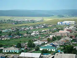 The settlement of Starobachaty is the most populous inhabited locality in Belovsky District[1] | |
.svg.png.webp) Flag  Coat of arms | |
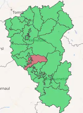
Location of Belovsky District in Kemerovo Oblast | |
| Coordinates: 54°25′N 86°18′E | |
| Country | Russia |
| Federal subject | Kemerovo Oblast[2] |
| Established | 4 September 1924 |
| Administrative center | Vishnevka[2] |
| Area | |
| • Total | 3,400 km2 (1,300 sq mi) |
| Population | |
| • Total | 30,204 |
| • Estimate (2018)[4] | 27,083 (−10.3%) |
| • Density | 8.9/km2 (23/sq mi) |
| • Urban | 0% |
| • Rural | 100% |
| Administrative structure | |
| • Administrative divisions | 8 rural territorie |
| • Inhabited localities[2] | 47 Rural localities |
| Municipal structure | |
| • Municipally incorporated as | Belovsky Municipal District[5] |
| • Municipal divisions[5] | 0 Urban settlements, 8 Rural settlements |
| Time zone | UTC+7 (MSK+4 |
| OKTMO ID | 32601000 |
| Website | http://www.belovorn.ru |
Geography
Belovsky District is at the center of the Kuznetsk Basin (the "Kuzbass" coal region of the Tom River basin), and is at the center of Kemerovo Oblast. The district's borders effectively surround the large town of Belovo, Kemerovo Oblast, and is just south of the town of Leninsk-Kuznetsky (city). The terrain is mostly flat in the center, on the plain of the Inya River as it flows north and west; the Tom River runs north to south along the east border. Rolling hills rise in the east towards the Kuznetsk Alatau, and towards the Salair Ridge in the west. Vegetation is steppe and mountain forest-steppe, with patches of forest scattered around the region.
The district is about 100 km west-to-east, and 71 km north-to-south. It is located about 100 km south of the city of Kemerovo, and 100 km north of Novokuznetsk. Subdivisions of the district include 8 rural areas, and 47 rural settlements.[9]
Belovsky borders with Krapivinsky District in the north, Novokuznetsky District in the east, Prokopyevsky District in the south, and with Guryevsky District in the west.
Climate
The climate of the district is humid continental (Koppen Dfb). The average temperature in January is −17.4 °C (0.7 °F), and is 16.8 °C (62.2 °F) in July. The frost-free period in the north of the district is 145 in north, and the average annual precipitation is 370–495 mm/year.[3]
Economy
The two dominant industries of the district are coal and agriculture. There are three coal fields in the district: Bachatskij, Shestakov, Karakansky. 15% of the coal production of the Kuznetz basin comes from the Belovsky District. Agricultureis diverse, with grains, potatoes, livestock and dairy.[3]
References
- Russian Federal State Statistics Service (2011). "Всероссийская перепись населения 2010 года. Том 1" [2010 All-Russian Population Census, vol. 1]. Всероссийская перепись населения 2010 года [2010 All-Russia Population Census] (in Russian). Federal State Statistics Service.
- Law #215-OZ
- "About the Area" (in Russian). Belovsky District (Official Website). Archived from the original on June 20, 2016. Retrieved June 26, 2016.
- "26. Численность постоянного населения Российской Федерации по муниципальным образованиям на 1 января 2018 года". Federal State Statistics Service. Retrieved January 23, 2019.
- Law #104-OZ
- "Об исчислении времени". Официальный интернет-портал правовой информации (in Russian). June 3, 2011. Retrieved January 19, 2019.
- Russian Federal State Statistics Service (May 21, 2004). "Численность населения России, субъектов Российской Федерации в составе федеральных округов, районов, городских поселений, сельских населённых пунктов – районных центров и сельских населённых пунктов с населением 3 тысячи и более человек" [Population of Russia, Its Federal Districts, Federal Subjects, Districts, Urban Localities, Rural Localities—Administrative Centers, and Rural Localities with Population of Over 3,000] (XLS). Всероссийская перепись населения 2002 года [All-Russia Population Census of 2002] (in Russian).
- "Всесоюзная перепись населения 1989 г. Численность наличного населения союзных и автономных республик, автономных областей и округов, краёв, областей, районов, городских поселений и сёл-райцентров" [All Union Population Census of 1989: Present Population of Union and Autonomous Republics, Autonomous Oblasts and Okrugs, Krais, Oblasts, Districts, Urban Settlements, and Villages Serving as District Administrative Centers]. Всесоюзная перепись населения 1989 года [All-Union Population Census of 1989] (in Russian). Институт демографии Национального исследовательского университета: Высшая школа экономики [Institute of Demography at the National Research University: Higher School of Economics]. 1989 – via Demoscope Weekly.
- "About the Area" (in Russian). Belovsky District (Official Website). Archived from the original on June 20, 2016. Retrieved June 27, 2016.
Sources
- Совет народных депутатов Кемеровской области. Закон №215-ОЗ от 27 декабря 2007 г. «Об административно-территориальном устройстве Кемеровской области», в ред. Закона №131-ОЗ от 22 декабря 2014 г. «О внесении изменений в Закон Кемеровской области "О статусе и границах муниципальных образований" и Закон Кемеровской области "Об административно-территориальном устройстве Кемеровской области"». Вступил в силу в день, следующий за днём официального опубликования. Опубликован: "Кузбасс", №243, 28 декабря 2007 г. (Council of People's Deputies of Kemerovo Oblast. Law #215-OZ of December 27, 2007 On the Administrative-Territorial Structure of Kemerovo Oblast, as amended by the Law #131-OZ of December 22, 2014 On Amending the Law of Kemerovo Oblast "On the Status and the Borders of the Municipal Formations" and the Law of Kemerovo Oblast "On the Administrative-Territorial Structure of Kemerovo Oblast". Effective as of the day following the official publication date.).
- Совет народных депутатов Кемеровской области. Закон №104-ОЗ от 17 декабря 2004 г. «О статусе и границах муниципальных образований», в ред. Закона №123-ОЗ от 22 декабря 2015 г. «О внесении изменений в Закон Кемеровской области "О статусе и границах муниципальных образований"». Вступил в силу со дня официального опубликования. Опубликован: "Кузбасс", №242, 24 декабря 2004 г. (Council of People's Deputies of Chelyabinsk Oblast. Law #104-OZ of December 17, 2004 On the Status and the Borders of the Municipal Formations, as amended by the Law #123-OZ of December 22, 2015 On Amending the Law of Kemerovo Oblast "On the Status and the Borders of the Municipal Formations". Effective as of the official publication date.).
External links
| Administrative districts | ||
|---|---|---|
| Urban-type settlements under oblast jurisdiction | ||
| Cities and towns | ||
| Urban-type settlements | ||