Chebulinsky District
Chebulinsky District (Russian: Чебули́нский райо́н) is an administrative district (raion), one of the nineteen in Kemerovo Oblast, Russia.[1] As a municipal division, it is incorporated as Chebulinsky Municipal District.[6] It is located in the north of the oblast. The area of the district is 3,780 square kilometers (1,460 sq mi).[2] Its administrative center is the urban locality (an urban-type settlement) of Verkh-Chebula.[1] Population: 16,348 (2010 Census);[3] 17,971 (2002 Census);[8] 17,723 (1989 Census).[9] The population of Verkh-Chebula accounts for 31.0% of the district's total population.[3]
Chebulinsky District
Чебулинский район | |
|---|---|
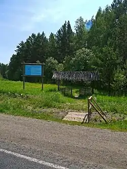 Nature Trail near Verkh Chebula | |
.png.webp) Flag | |
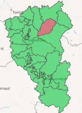
Location of Chebulinsky District in Kemerovo Oblast | |
| Coordinates: 56°02′24″N 87°37′12″E | |
| Country | Russia |
| Federal subject | Kemerovo Oblast[1] |
| Established | 1924 |
| Administrative center | Verkh-Chebula[1] |
| Area | |
| • Total | 3,700 km2 (1,400 sq mi) |
| Population | |
| • Total | 16,348 |
| • Estimate (2018)[4] | 14,460 (−11.5%) |
| • Density | 4.4/km2 (11/sq mi) |
| • Urban | 31.0% |
| • Rural | 69.0% |
| Administrative structure | |
| • Administrative divisions | 1 Urban-type settlements, 6 Rural territories |
| • Inhabited localities[1] | 1 Urban-type settlements[5], 28 Rural localities |
| Municipal structure | |
| • Municipally incorporated as | Chebulinsky Municipal District[6] |
| • Municipal divisions[6] | 1 Urban settlements, 6 Rural settlements |
| Time zone | UTC+7 (MSK+4 |
| OKTMO ID | 32637000 |
| Website | http://www.ako.ru/chebula/ |
Geography
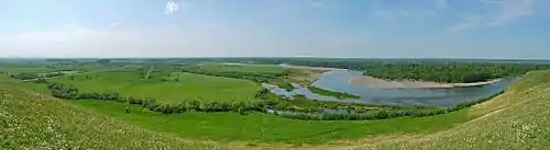
Chebulinsky District is about 40 km northeast of the City of Kemerovo, in the Chebuly Basin, for which the district is named. It is located just to the of the Kuznetsk Alatau mountains. The Kiya River flows down from the mountains on its way north through the eastern border of the district. The district is known as the discovery site of many early Cretaceous dinosaur skeletons, including Psittacosaurus sibiricus. The area also features a wetland complex important to rare birds ("Shestakovo Swamp"), two extinct volcanos, and over 50 Paleolithic to Middle Aged archaeological sites.
Vegetation in the area is steppe and mountain forest-steppe. The forested areas are scattered. The district is about 100 km long, oriented towards the northeast. The road from Kemerovo to Krasnoyarsk in the east runs through the northern edge of the District. Subdivisions of the district include 1 urban area, and 7 rural settlements.[10]
Chebulinsky District borders with Mariinsky District to the north, Tisulsky District in the east and south, and with Kemerovsky District to the west.
Economy
Chebulinsky is an agricultural district, with production and processing of grains, livestock and dairy products. [2]
References
- Law #215-OZ
- "About the Area" (in Russian). Chebulinsky District (Official Web Site). Archived from the original on August 3, 2017. Retrieved June 26, 2016.
- Russian Federal State Statistics Service (2011). "Всероссийская перепись населения 2010 года. Том 1" [2010 All-Russian Population Census, vol. 1]. Всероссийская перепись населения 2010 года [2010 All-Russia Population Census] (in Russian). Federal State Statistics Service.
- "26. Численность постоянного населения Российской Федерации по муниципальным образованиям на 1 января 2018 года". Federal State Statistics Service. Retrieved January 23, 2019.
- The count of urban-type settlements may include the work settlements, the resort settlements, the suburban (dacha) settlements, as well as urban-type settlements proper.
- Law #104-OZ
- "Об исчислении времени". Официальный интернет-портал правовой информации (in Russian). June 3, 2011. Retrieved January 19, 2019.
- Russian Federal State Statistics Service (May 21, 2004). "Численность населения России, субъектов Российской Федерации в составе федеральных округов, районов, городских поселений, сельских населённых пунктов – районных центров и сельских населённых пунктов с населением 3 тысячи и более человек" [Population of Russia, Its Federal Districts, Federal Subjects, Districts, Urban Localities, Rural Localities—Administrative Centers, and Rural Localities with Population of Over 3,000] (XLS). Всероссийская перепись населения 2002 года [All-Russia Population Census of 2002] (in Russian).
- "Всесоюзная перепись населения 1989 г. Численность наличного населения союзных и автономных республик, автономных областей и округов, краёв, областей, районов, городских поселений и сёл-райцентров" [All Union Population Census of 1989: Present Population of Union and Autonomous Republics, Autonomous Oblasts and Okrugs, Krais, Oblasts, Districts, Urban Settlements, and Villages Serving as District Administrative Centers]. Всесоюзная перепись населения 1989 года [All-Union Population Census of 1989] (in Russian). Институт демографии Национального исследовательского университета: Высшая школа экономики [Institute of Demography at the National Research University: Higher School of Economics]. 1989 – via Demoscope Weekly.
- "About the Arrl=http://chebula.ru/o-rayone/" (in Russian). Chebulinsky District (Official Web Site). Missing or empty
|url=(help)
Sources
- Совет народных депутатов Кемеровской области. Закон №215-ОЗ от 27 декабря 2007 г. «Об административно-территориальном устройстве Кемеровской области», в ред. Закона №131-ОЗ от 22 декабря 2014 г. «О внесении изменений в Закон Кемеровской области "О статусе и границах муниципальных образований" и Закон Кемеровской области "Об административно-территориальном устройстве Кемеровской области"». Вступил в силу в день, следующий за днём официального опубликования. Опубликован: "Кузбасс", №243, 28 декабря 2007 г. (Council of People's Deputies of Kemerovo Oblast. Law #215-OZ of December 27, 2007 On the Administrative-Territorial Structure of Kemerovo Oblast, as amended by the Law #131-OZ of December 22, 2014 On Amending the Law of Kemerovo Oblast "On the Status and the Borders of the Municipal Formations" and the Law of Kemerovo Oblast "On the Administrative-Territorial Structure of Kemerovo Oblast". Effective as of the day following the official publication date.).
- Совет народных депутатов Кемеровской области. Закон №104-ОЗ от 17 декабря 2004 г. «О статусе и границах муниципальных образований», в ред. Закона №123-ОЗ от 22 декабря 2015 г. «О внесении изменений в Закон Кемеровской области "О статусе и границах муниципальных образований"». Вступил в силу со дня официального опубликования. Опубликован: "Кузбасс", №242, 24 декабря 2004 г. (Council of People's Deputies of Chelyabinsk Oblast. Law #104-OZ of December 17, 2004 On the Status and the Borders of the Municipal Formations, as amended by the Law #123-OZ of December 22, 2015 On Amending the Law of Kemerovo Oblast "On the Status and the Borders of the Municipal Formations". Effective as of the official publication date.).
| Administrative districts | ||
|---|---|---|
| Urban-type settlements under oblast jurisdiction | ||
| Cities and towns | ||
| Urban-type settlements | ||