Guryevsky District, Kemerovo Oblast
Guryevsky District (Russian: Гу́рьевский райо́н) is an administrative district (raion), one of the nineteen in Kemerovo Oblast, Russia.[1] As a municipal division, it is incorporated as Guryevsky Municipal District.[5] It is located in the west of the oblast and borders with Prokopyevsky, Belovsky, and Leninsk-Kuznetsky Districts of Kemerovo Oblast and with Altai Krai and Novosibirsk Oblast in the west. The area of the district is 2,180 square kilometers (840 sq mi).[2] Its administrative center is the town of Guryevsk (which is not administratively a part of the district).[1] Population: 10,617 (2010 Census);[3] 12,057 (2002 Census);[7] 20,816 (1989 Census).[8]
Guryevsky District
Гурьевский район | |
|---|---|
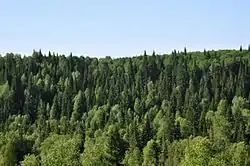 Salairsky Nature Park, Guryevsky District | |
.png.webp) Flag .png.webp) Coat of arms | |
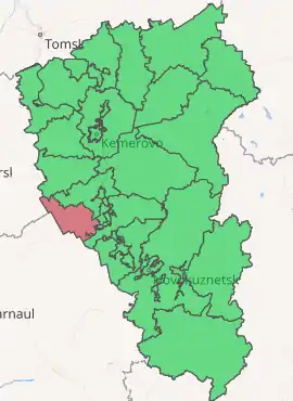
Location of Guryevsky District in Kemerovo Oblast | |
| Coordinates: 54°17′N 85°56′E | |
| Country | Russia |
| Federal subject | Kemerovo Oblast[1] |
| Established | 1988 |
| Administrative center | Guryevsk[1] |
| Area | |
| • Total | 2,180 km2 (840 sq mi) |
| Population | |
| • Total | 10,617 |
| • Estimate (2018)[4] | 39,945 (+276.2%) |
| • Density | 4.9/km2 (13/sq mi) |
| • Urban | 0% |
| • Rural | 100% |
| Administrative structure | |
| • Administrative divisions | 7 rural territorie |
| • Inhabited localities[1] | 27 Rural localities |
| Municipal structure | |
| • Municipally incorporated as | Guryevsky Municipal District[5] |
| • Municipal divisions[5] | 2 Urban settlements, 7 Rural settlements |
| Time zone | UTC+7 (MSK+4 |
| OKTMO ID | 32602000 |
| Website | http://www.admgur.ru/ |
Geography
Gurevsky District is on the east slope of the Salair Ridge, and extension of the Altai mountains. It is on the west edge of the Kuznetsk Depression, site of the Kuznetsk Basin (the "Kuzbass" coal region), although the district itself is just off the main coal bearing ground.[9] The district is 10 km west of the large town of Belovo, Kemerovo Oblast. The terrain is that of eroded plateau-type mountains and hills as the district follows the northwest-to-southeast orientation of the ridge. Vegetation is mountain forest and forest-steppe, with patches of forest scattered around the region.
The district is about 80 km north-to-south, and 50 km west-to-east, and surrounds the administratively-separate town of Guryev. It is located about 160 km south of the regional city of Kemerovo. Subdivisions of the district include 2 urban and 7 rural settlements.[10] The climate of the district is humid continental (Koppen Dfb).
Economy
The major industries of the district are metallurgy and timber. The district has explored reserves of copper-pyrites ores, and also produces and processes limestone and cement.[10] The modern "Altai-Kuzbass" highway passes west–east through the middle of Guryevsky District.
History
Tsar Alexander I established a silver mining complex in the district in 1816. After a dozen years the plant was converted to an iron works, which supplied tools and farm equipment to the region. The current district structure was established in 1988, having been a part of Belovsky District from 1963 to 1986.[11]
Administrative and municipal status
Within the framework of administrative divisions, Guryevsky District is one of the nineteen in the oblast.[1] The town of Guryevsk serves as its administrative center, despite being incorporated separately as a town under oblast jurisdiction—an administrative unit with the status equal to that of the districts (and which, in addition to Guryevsk, also includes the town of Salair and two rural localities).[1]
As a municipal division, the district is incorporated as Guryevsky Municipal District.[5] The town of Guryevsk is incorporated within it as Guryevskoye Urban Settlement.[5] The town of Salair and the two rural localities are incorporated within the municipal district as Salairskoye Urban Settlement.[5]
References
- Law #215-OZ
- "District Statistics - Guryev District" (in Russian). Federal State Statistics Service, Russian Federation. Retrieved June 26, 2016.
- Russian Federal State Statistics Service (2011). "Всероссийская перепись населения 2010 года. Том 1" [2010 All-Russian Population Census, vol. 1]. Всероссийская перепись населения 2010 года [2010 All-Russia Population Census] (in Russian). Federal State Statistics Service.
- "26. Численность постоянного населения Российской Федерации по муниципальным образованиям на 1 января 2018 года". Federal State Statistics Service. Retrieved January 23, 2019.
- Law #104-OZ
- "Об исчислении времени". Официальный интернет-портал правовой информации (in Russian). June 3, 2011. Retrieved January 19, 2019.
- Russian Federal State Statistics Service (May 21, 2004). "Численность населения России, субъектов Российской Федерации в составе федеральных округов, районов, городских поселений, сельских населённых пунктов – районных центров и сельских населённых пунктов с населением 3 тысячи и более человек" [Population of Russia, Its Federal Districts, Federal Subjects, Districts, Urban Localities, Rural Localities—Administrative Centers, and Rural Localities with Population of Over 3,000] (XLS). Всероссийская перепись населения 2002 года [All-Russia Population Census of 2002] (in Russian).
- "Всесоюзная перепись населения 1989 г. Численность наличного населения союзных и автономных республик, автономных областей и округов, краёв, областей, районов, городских поселений и сёл-райцентров" [All Union Population Census of 1989: Present Population of Union and Autonomous Republics, Autonomous Oblasts and Okrugs, Krais, Oblasts, Districts, Urban Settlements, and Villages Serving as District Administrative Centers]. Всесоюзная перепись населения 1989 года [All-Union Population Census of 1989] (in Russian). Институт демографии Национального исследовательского университета: Высшая школа экономики [Institute of Demography at the National Research University: Higher School of Economics]. 1989 – via Demoscope Weekly.
- "Kuznetsk Coal Basin - Map". Russian Coal. Independent analytical agency "Rosinformugol". Retrieved July 2, 2016.
- "State - General Information" (in Russian). Guryevsky District (Official Website). Retrieved July 2, 2016.
- "Guryev District - History". Guryev District (Official Website). Guryev District Administration. Retrieved June 30, 2016.
Sources
- Совет народных депутатов Кемеровской области. Закон №215-ОЗ от 27 декабря 2007 г. «Об административно-территориальном устройстве Кемеровской области», в ред. Закона №131-ОЗ от 22 декабря 2014 г. «О внесении изменений в Закон Кемеровской области "О статусе и границах муниципальных образований" и Закон Кемеровской области "Об административно-территориальном устройстве Кемеровской области"». Вступил в силу в день, следующий за днём официального опубликования. Опубликован: "Кузбасс", №243, 28 декабря 2007 г. (Council of People's Deputies of Kemerovo Oblast. Law #215-OZ of December 27, 2007 On the Administrative-Territorial Structure of Kemerovo Oblast, as amended by the Law #131-OZ of December 22, 2014 On Amending the Law of Kemerovo Oblast "On the Status and the Borders of the Municipal Formations" and the Law of Kemerovo Oblast "On the Administrative-Territorial Structure of Kemerovo Oblast". Effective as of the day following the official publication date.).
- Совет народных депутатов Кемеровской области. Закон №104-ОЗ от 17 декабря 2004 г. «О статусе и границах муниципальных образований», в ред. Закона №123-ОЗ от 22 декабря 2015 г. «О внесении изменений в Закон Кемеровской области "О статусе и границах муниципальных образований"». Вступил в силу со дня официального опубликования. Опубликован: "Кузбасс", №242, 24 декабря 2004 г. (Council of People's Deputies of Chelyabinsk Oblast. Law #104-OZ of December 17, 2004 On the Status and the Borders of the Municipal Formations, as amended by the Law #123-OZ of December 22, 2015 On Amending the Law of Kemerovo Oblast "On the Status and the Borders of the Municipal Formations". Effective as of the official publication date.).
| Administrative districts | ||
|---|---|---|
| Urban-type settlements under oblast jurisdiction | ||
| Cities and towns | ||
| Urban-type settlements | ||
External links
- Guryevsky District on OpenStreetMap.org
- [USSR map NN 45-4 Salair.jpg Topographical Map of Salair Region, with Guryevsk in lower right]