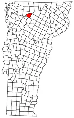
Belvidere, Vermont
Belvidere is a town in Lamoille County, Vermont, United States. The population was 348 at the 2010 census,[2] up from 294 at the 2000 census. Belvidere contains the hamlets of Belvidere Center, Belvidere Corners and Belvidere Junction. In 1963, part of Averys Gore in Franklin County became part of Belvidere, while the other part became part of Montgomery.
Belvidere, Vermont | |
|---|---|
 | |
 Belvidere, Vermont | |
 Belvidere, Vermont Location in the United States | |
| Coordinates: 44°45′19″N 72°40′49″W | |
| Country | United States |
| State | Vermont |
| County | Lamoille |
| Communities | Belvidere Center Belvidere Corners Belvidere Junction |
| Area | |
| • Total | 32.14 sq mi (83.24 km2) |
| • Land | 32.09 sq mi (83.10 km2) |
| • Water | 0.05 sq mi (0.13 km2) |
| Elevation | 1,053 ft (321 m) |
| Population | |
| • Total | 348 |
| • Density | 11/sq mi (4.2/km2) |
| Time zone | UTC-5 (Eastern (EST)) |
| • Summer (DST) | UTC-4 (EDT) |
| ZIP code | 05442 |
| Area code(s) | 802 |
| FIPS code | 50-04375[3] |
| GNIS feature ID | 1462038[4] |
Geography
Belvidere is the northernmost town in Lamoille County and is bordered by Franklin County to the north. According to the United States Census Bureau, the town has a total area of 32.1 square miles (83.2 km2), of which 0.04 square miles (0.1 km2), or 0.16%, are water.[1] The North Branch of the Lamoille River flows east to west across the center of the town, and most of the town's settlement is in the North Branch valley. Vermont Route 109 runs up the valley and has its eastern terminus at Vermont Route 118 at Belvidere Corners in the eastern part of town. Route 109 leads southwest 11 miles (18 km) to Jeffersonville, while Route 118 leads north 10 miles (16 km) to Montgomery and southeast 8 miles (13 km) to Eden.
Demographics
| Historical population | |||
|---|---|---|---|
| Census | Pop. | %± | |
| 1810 | 217 | — | |
| 1820 | 198 | −8.8% | |
| 1830 | 185 | −6.6% | |
| 1840 | 207 | 11.9% | |
| 1850 | 256 | 23.7% | |
| 1860 | 366 | 43.0% | |
| 1870 | 369 | 0.8% | |
| 1880 | 400 | 8.4% | |
| 1890 | 571 | 42.8% | |
| 1900 | 428 | −25.0% | |
| 1910 | 429 | 0.2% | |
| 1920 | 363 | −15.4% | |
| 1930 | 258 | −28.9% | |
| 1940 | 220 | −14.7% | |
| 1950 | 207 | −5.9% | |
| 1960 | 155 | −25.1% | |
| 1970 | 189 | 21.9% | |
| 1980 | 218 | 15.3% | |
| 1990 | 228 | 4.6% | |
| 2000 | 294 | 28.9% | |
| 2010 | 348 | 18.4% | |
| 2014 (est.) | 355 | [5] | 2.0% |
| U.S. Decennial Census[6] | |||
As of the census[3] of 2000, there were 294 people, 114 households, and 71 families residing in the town. The population density was 9.1 people per square mile (3.5/km2). There were 194 housing units at an average density of 6.0 per square mile (2.3/km2). The racial makeup of the town was 99.66% White, and 0.34% from two or more races. Hispanic or Latino of any race were 0.34% of the population.
There were 114 households, out of which 36.8% had children under the age of 18 living with them, 55.3% were married couples living together, 2.6% had a female householder with no husband present, and 37.7% were non-families. 24.6% of all households were made up of individuals, and 8.8% had someone living alone who was 65 years of age or older. The average household size was 2.58 and the average family size was 3.14.
In the town, the population was spread out, with 27.9% under the age of 18, 7.8% from 18 to 24, 34.4% from 25 to 44, 18.4% from 45 to 64, and 11.6% who were 65 years of age or older. The median age was 35 years. For every 100 females, there were 101.4 males. For every 100 females age 18 and over, there were 98.1 males.
The median income for a household in the town was $44,583, and the median income for a family was $50,500. Males had a median income of $36,250 versus $25,500 for females. The per capita income for the town was $19,081. About 8.8% of families and 9.4% of the population were below the poverty line, including 16.9% of those under the age of eighteen and 8.6% of those 65 or over.
References
- "2019 U.S. Gazetteer Files". United States Census Bureau. Retrieved January 27, 2021.
- "Total Population: 2010 Census DEC Summary File 1 (P1), Belvidere town, Lamoille County, Vermont". data.census.gov. U.S. Census Bureau. Retrieved January 27, 2021.
- "U.S. Census website". United States Census Bureau. Retrieved 2008-01-31.
- "US Board on Geographic Names". United States Geological Survey. 2007-10-25. Retrieved 2008-01-31.
- "Annual Estimates of the Resident Population for Incorporated Places: April 1, 2010 to July 1, 2014". Archived from the original on 2015-05-23. Retrieved June 4, 2015.
- "U.S. Decennial Census". United States Census Bureau. Retrieved May 16, 2015.
Municipalities and communities of Lamoille County, Vermont, United States | ||
|---|---|---|
| Towns | 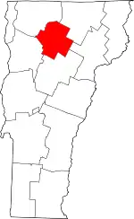 Map of Vermont highlighting Lamoille County | |
| Villages | ||
| CDP | ||
| Unincorporated communities | ||
| ||