Bemarivo River
The Bemarivo River (/be.mari.v/), literally the big shallow, is located in northern Madagascar. It drains to the north-eastern coast, into the Indian Ocean. It drains the eastern part of the Tsaratanana Massif and the northern half of the Marojejy Massif.
| Bemarivo River | |
|---|---|
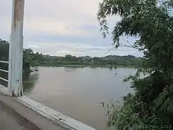 Bemarivo river from Route Nationale 5a | |
 Map of Malagasy rivers (Bemarivo flows from the central-northern part to the eastern coast). | |
| Location | |
| Country | Madagascar |
| Region | Sava |
| Cities | Nosiarina, Ambinanybe, Antafiamazava |
| Physical characteristics | |
| Source | |
| • elevation | 2,100 m (6,900 ft) |
| Mouth | |
• location | Indian Ocean |
• coordinates | 14°08′45″S 50°09′19″E |
| Length | 140 km (87 mi) |
| Basin size | 5,400 km2 (2,100 sq mi) |
| Basin features | |
| Tributaries | |
| • right | Androranga River |
It is crossed by the RN 5a near Nosiarina. Its mouth is situated in the north of Sambava.
It serves as the northern edge of the territory known as Betsimisaraka.[1] Confusingly, a tributary of the Sofia River is also called the Bemarivo River.[2]
References
- Madagascar: A Country Study, Helen Chapin Metz, ed. Library of Congress, 1994., accessed 14 August 2008
- Sparks, J. S. (2008). Phylogeny of the Cichlid Subfamily Etroplinae and Taxonomic Revision of the Malagasy Cichlid Genus Paretroplus (Teleostei: Cichlidae). Bulletin of the American Museum of Natural History Number 314: 1-151
This article is issued from Wikipedia. The text is licensed under Creative Commons - Attribution - Sharealike. Additional terms may apply for the media files.
