Benaughlin Mountain
Benaughlin Mountain (from Irish: Binn Eachlabhra) is a mountain in the Cuilcagh Mountain range in County Fermanagh, Northern Ireland. Its composition is mainly of sandstone, limestone and shale.
| Benaughlin | |
|---|---|
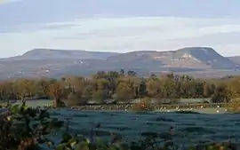
 Benaughlin Mountain viewed from South Fermanagh in November 2007. (Cuilcagh can be seen on the upper left.) | |
| Highest point | |
| Elevation | 370 m (1,210 ft) |
| Prominence | 124 m (407 ft) |
| Geography | |
| Location | County Fermanagh, Northern Ireland |
| Parent range | Cuilcagh Mountains |
| OSI/OSNI grid | H178315 |
| Topo map | OSi Discovery 26 |
At its highest point, Benaughlin is 373 metres (1,224 ft) above sea level. A section of the Ulster Way passes around the side of the mountain, within 300 m of the summit.[1]
The name Benaughlin comes from the Irish: Binn Eachlabhra which means "peak of the speaking horse".[2] Legends tell of a large, white horse (An Chopail Bán) which would appear on the slopes of the mountain each year on the last Sunday of July, and talk to local people.[3] The mountain is also known as Bin Mountain to local residents.[4]

The blanket bog which covers the mountain was used as a source of fuel for the wealthy landowners in the area who lived in the nearby stately home of Florence Court. A path known as the Donkey Trail meanders up the side of the mountain; this was the route used for bringing the turf down off the mountain side.
See also
- List of Marilyns in Northern Ireland
References
- Discovery Sheet 26 (Map) (Second Edition 2004 ed.). OSi.
- "DiscoverIreland.ie". Archived from the original on 2 August 2012. Retrieved 27 January 2009.
- Lyle, Paul; Geological Survey of Northern Ireland (27 October 2010). Between Rocks and Hard Places: Discovering Ireland's Northern Landscapes. The Stationery Office. p. 7. ISBN 9780337095870.
- Leonard, Philip (January 2007). "Kinawley". The Leonards of Kinglass. Archived from the original on 11 September 2004. Retrieved 26 July 2012.
External links
| Wikimedia Commons has media related to Benaughlin Mountain. |
- BBC Northern Ireland - Off the Beaten Track hike route with map